East Renton Highlands, Washington
| East Renton Highlands, Washington | |
|---|---|
| CDP | |
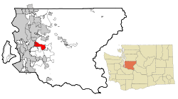 Location of East Renton Highlands, Washington | |
| Coordinates: 47°28′52″N 122°7′7″W / 47.48111°N 122.11861°WCoordinates: 47°28′52″N 122°7′7″W / 47.48111°N 122.11861°W | |
| Country | United States |
| State | Washington |
| County | King |
| Area | |
| • Total | 12.7 sq mi (32.8 km2) |
| • Land | 12.6 sq mi (32.6 km2) |
| • Water | 0.1 sq mi (0.2 km2) |
| Elevation | 525 ft (160 m) |
| Population (2010) | |
| • Total | 11,140 |
| • Density | 1,055.1/sq mi (407.4/km2) |
| Time zone | Pacific (PST) (UTC-8) |
| • Summer (DST) | PDT (UTC-7) |
| FIPS code | 53-19857[1] |
| GNIS feature ID | 1867606[2] |
East Renton Highlands is a census-designated place (CDP) in King County, Washington, United States, located between Issaquah and Renton. The population was 11,140 at the 2010 census.
East Renton Highlands is part of the potential annexation area (PAA) of Renton, but in February 2007 voters defeated a 1,475-acre (5.97 km2) annexation proposal 3 to 1. In January 2008, the Renton City Council accepted a petition, using the 60% Direct Method, for the proposed Liberty Annexation; 193 acres (0.78 km2) located in the vicinity of 156th Ave. SE, SE 144th St., and SE 134th St.[3]
Geography
East Renton Highlands is located at 47°28′52″N 122°7′7″W / 47.48111°N 122.11861°W (47.481022, -122.118605).[4]
According to the United States Census Bureau, the CDP has a total area of 12.7 square miles (32.8 km²), of which, 12.6 square miles (32.6 km²) of it is land and 0.1 square miles (0.2 km²) of it (0.71%) is water.
Demographics
| Historical population | |||
|---|---|---|---|
| Census | Pop. | %± | |
| 1980 | 12,033 | — | |
| 1990 | 13,218 | 9.8% | |
| 2000 | 13,264 | 0.3% | |
| 2010 | 11,140 | −16.0% | |
| source:[5] | |||
As of the census[1] of 2000, there were 13,264 people, 4,668 households, and 3,743 families residing in the CDP. The population density was 1,055.1 people per square mile (407.4/km²). There were 4,760 housing units at an average density of 378.6/sq mi (146.2/km²). The racial makeup of the CDP was 90.76% White, 1.46% African American, 0.86% Native American, 3.10% Asian, 0.11% Pacific Islander, 1.01% from other races, and 2.71% from two or more races. Hispanic or Latino of any race were 3.43% of the population.
There were 4,668 households out of which 37.9% had children under the age of 18 living with them, 68.3% were married couples living together, 8.1% had a female householder with no husband present, and 19.8% were non-families. 14.4% of all households were made up of individuals and 3.7% had someone living alone who was 65 years of age or older. The average household size was 2.83 and the average family size was 3.12.
In the CDP the population was spread out with 26.7% under the age of 18, 6.5% from 18 to 24, 30.6% from 25 to 44, 28.4% from 45 to 64, and 7.8% who were 65 years of age or older. The median age was 38 years. For every 100 females there were 104.0 males. For every 100 females age 18 and over, there were 101.5 males.
The median income for a household in the CDP was $65,268, and the median income for a family was $65,855. Males had a median income of $50,149 versus $33,917 for females. The per capita income for the CDP was $27,089. About 3.2% of families and 4.5% of the population were below the poverty line, including 3.1% of those under age 18 and 6.1% of those age 65 or over.
References
- 1 2 "American FactFinder". United States Census Bureau. Retrieved 2008-01-31.
- ↑ "East Renton Highlands". Geographic Names Information System. United States Geological Survey.
- ↑ City of Renton. Accessed 2010-07-31.
- ↑ "US Gazetteer files: 2010, 2000, and 1990". United States Census Bureau. 2011-02-12. Retrieved 2011-04-23.
- ↑ "CENSUS OF POPULATION AND HOUSING (1790-2000)". U.S. Census Bureau. Retrieved 2010-07-31.
Municipalities and communities of King County, Washington, United States | ||
|---|---|---|
| Cities |
|  |
| Towns | ||
| CDPs |
| |
| Unincorporated communities | ||
| Indian reservation | ||
| Ghost towns | ||
| Footnotes | ‡This populated place also has portions in an adjacent county or counties | |