Eastern Washington
| Eastern Washington | |
| Inland Empire | |
| Region | |
| Country | United States |
|---|---|
| State | Washington |
| Part of | Pacific Northwest |
| Borders on | British Columbia, Eastern Oregon, Idaho Panhandle, Cascade Range/Western Washington |
| Parts | Central Washington |
| Rivers | Columbia River, Snake River, Yakima River |
| Coordinates | 47°30′N 119°0′W / 47.500°N 119.000°WCoordinates: 47°30′N 119°0′W / 47.500°N 119.000°W |
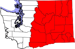 | |
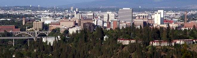
Eastern Washington is the portion of the US state of Washington east of the Cascade Range. The region contains the city of Spokane (the second largest city in the state), the Tri-Cities, the Columbia River and the Grand Coulee Dam, the Hanford Nuclear Reservation and the fertile farmlands of the Yakima Valley and the Palouse. Unlike in Western Washington, the climate is dry, including some nearly desert environments.
Statehood
There have been sporadic movements to create a 51st state out of Eastern Washington by splitting the current state down the Cascades, but proposals have rarely progressed out of the state legislature's committees. Recent proposals were made in 1996, 1999, and 2005. Proposed names for the new state have included Lincoln, and Columbia, or simply Eastern Washington. Many of these proposals were to include the Idaho Panhandle. See: State of Lincoln for more information.
Eastern Washington tends to vote Republican, whereas Western Washington usually supports the Democrats.
Climate

A significant difference between Eastern Washington and the western half of the state is its climate. While the west half of the state is located in a rainy oceanic climate, the eastern half receives little rainfall due to the rainshadow created by the Cascade Mountains. Also, due to being farther from the sea, the east side has both hotter summers and colder winters than the west. Most communities in Eastern Washington, for example, have significant yearly snowfall, while in the west snowfall is minimal and not seen every year. The east and west do still have some climatic traits in common, though: more rainfall in winter than summer, a lack of severe storms, and milder temperature ranges than more inland locations.
There is some variation in both rainfall throughout Eastern Washington. Generally, lower elevations are both hotter and drier than higher elevations. This is easily seen in the comparison between low-elevation Richland with higher elevation Spokane.
| Climate data for Richland, Washington | |||||||||||||
|---|---|---|---|---|---|---|---|---|---|---|---|---|---|
| Month | Jan | Feb | Mar | Apr | May | Jun | Jul | Aug | Sep | Oct | Nov | Dec | Year |
| Record high °F (°C) | 71 (22) |
73 (23) |
82 (28) |
92 (33) |
105 (41) |
110 (43) |
110 (43) |
113 (45) |
106 (41) |
89 (32) |
77 (25) |
66 (19) |
113 (45) |
| Average high °F (°C) | 40.7 (4.8) |
48.6 (9.2) |
57.9 (14.4) |
66.4 (19.1) |
75.3 (24.1) |
82.2 (27.9) |
90.5 (32.5) |
89.3 (31.8) |
80.6 (27) |
66.7 (19.3) |
50.7 (10.4) |
41.5 (5.3) |
65.87 (18.82) |
| Average low °F (°C) | 26.4 (−3.1) |
30.2 (−1) |
35.1 (1.7) |
40.8 (4.9) |
48.1 (8.9) |
54.7 (12.6) |
59.7 (15.4) |
58.7 (14.8) |
50.8 (10.4) |
41.2 (5.1) |
33.7 (0.9) |
28.2 (−2.1) |
42.3 (5.71) |
| Record low °F (°C) | −21 (−29) |
−22 (−30) |
11 (−12) |
23 (−5) |
30 (−1) |
38 (3) |
41 (5) |
39 (4) |
31 (−1) |
13 (−11) |
−6 (−21) |
−10 (−23) |
−22 (−30) |
| Average precipitation inches (mm) | 0.99 (25.1) |
0.70 (17.8) |
0.61 (15.5) |
0.49 (12.4) |
0.59 (15) |
0.54 (13.7) |
0.20 (5.1) |
0.23 (5.8) |
0.28 (7.1) |
0.54 (13.7) |
0.98 (24.9) |
1.05 (26.7) |
7.1 (180) |
| Average snowfall inches (cm) | 2.6 (6.6) |
1.5 (3.8) |
0.3 (0.8) |
0.0 (0) |
0.0 (0) |
0.0 (0) |
0.0 (0) |
0.0 (0) |
0.0 (0) |
trace | 0.6 (1.5) |
2.2 (5.6) |
7.1 (18) |
| Source: [1] | |||||||||||||
| Climate data for Spokane, Washington (Felts Field) | |||||||||||||
|---|---|---|---|---|---|---|---|---|---|---|---|---|---|
| Month | Jan | Feb | Mar | Apr | May | Jun | Jul | Aug | Sep | Oct | Nov | Dec | Year |
| Record high °F (°C) | 62 (17) |
64 (18) |
74 (23) |
94 (34) |
98 (37) |
108 (42) |
112 (44) |
112 (44) |
102 (39) |
90 (32) |
72 (22) |
63 (17) |
112 (44) |
| Average high °F (°C) | 37.1 (2.8) |
42.5 (5.8) |
51.0 (10.6) |
59.0 (15) |
68.6 (20.3) |
75.2 (24) |
87.0 (30.6) |
85.6 (29.8) |
75.6 (24.2) |
60.2 (15.7) |
44.8 (7.1) |
36.6 (2.6) |
60.3 (15.7) |
| Average low °F (°C) | 26.2 (−3.2) |
27.2 (−2.7) |
31.7 (−0.2) |
36.2 (2.3) |
43.3 (6.3) |
50.3 (10.2) |
56.2 (13.4) |
54.8 (12.7) |
46.6 (8.1) |
37.9 (3.3) |
30.6 (−0.8) |
25.6 (−3.6) |
38.9 (3.8) |
| Record low °F (°C) | −10 (−23) |
−3 (−19) |
2 (−17) |
24 (−4) |
28 (−2) |
37 (3) |
39 (4) |
40 (4) |
26 (−3) |
12 (−11) |
−2 (−19) |
−10 (−23) |
−10 (−23) |
| Average precipitation inches (mm) | 1.92 (48.8) |
1.14 (29) |
1.91 (48.5) |
1.23 (31.2) |
1.51 (38.4) |
1.66 (42.2) |
0.40 (10.2) |
0.51 (13) |
0.61 (15.5) |
1.10 (27.9) |
1.94 (49.3) |
2.31 (58.7) |
16.25 (412.8) |
| Source: [2] | |||||||||||||
| Climate data for Spokane, Washington (Spokane Int'l), 1981–2010 normals | |||||||||||||
|---|---|---|---|---|---|---|---|---|---|---|---|---|---|
| Month | Jan | Feb | Mar | Apr | May | Jun | Jul | Aug | Sep | Oct | Nov | Dec | Year |
| Record high °F (°C) | 62 (17) |
63 (17) |
74 (23) |
90 (32) |
97 (36) |
105 (41) |
108 (42) |
108 (42) |
98 (37) |
87 (31) |
70 (21) |
60 (16) |
108 (42) |
| Average high °F (°C) | 34.5 (1.4) |
39.7 (4.3) |
49.0 (9.4) |
57.3 (14.1) |
66.5 (19.2) |
73.9 (23.3) |
83.4 (28.6) |
83.0 (28.3) |
73.0 (22.8) |
58.1 (14.5) |
41.7 (5.4) |
32.3 (0.2) |
57.7 (14.3) |
| Average low °F (°C) | 23.7 (−4.6) |
25.4 (−3.7) |
30.6 (−0.8) |
35.8 (2.1) |
42.8 (6) |
49.5 (9.7) |
55.3 (12.9) |
54.8 (12.7) |
46.4 (8) |
36.3 (2.4) |
28.8 (−1.8) |
21.5 (−5.8) |
37.6 (3.1) |
| Record low °F (°C) | −30 (−34) |
−24 (−31) |
−10 (−23) |
14 (−10) |
24 (−4) |
33 (1) |
37 (3) |
35 (2) |
22 (−6) |
7 (−14) |
−21 (−29) |
−25 (−32) |
−30 (−34) |
| Average precipitation inches (mm) | 1.79 (45.5) |
1.33 (33.8) |
1.61 (40.9) |
1.28 (32.5) |
1.62 (41.1) |
1.25 (31.8) |
.64 (16.3) |
.59 (15) |
.67 (17) |
1.18 (30) |
2.30 (58.4) |
2.29 (58.2) |
16.55 (420.5) |
| Average snowfall inches (cm) | 12.0 (30.5) |
7.2 (18.3) |
3.7 (9.4) |
1.0 (2.5) |
.1 (0.3) |
0 (0) |
0 (0) |
0 (0) |
0 (0) |
.1 (0.3) |
7.2 (18.3) |
14.9 (37.8) |
46.2 (117.3) |
| Average precipitation days (≥ 0.01 in) | 13.4 | 10.4 | 11.6 | 10.1 | 10.2 | 7.9 | 5.0 | 3.8 | 5.1 | 7.8 | 13.7 | 13.2 | 112.2 |
| Average snowy days (≥ 0.1 in) | 8.9 | 5.1 | 4.1 | 1.1 | .3 | 0 | 0 | 0 | 0 | .2 | 4.7 | 9.8 | 34.2 |
| Mean monthly sunshine hours | 77.5 | 118.7 | 198.4 | 243.0 | 297.6 | 324.0 | 381.3 | 341.0 | 270.0 | 192.2 | 75.0 | 58.9 | 2,577.6 |
| Source #1: NOAA[3] | |||||||||||||
| Source #2: HKO (sun only 1961−1990)[4] | |||||||||||||
Geography
Nomenclature
Other terms used for Eastern Washington or large parts of it include:
- Columbia Basin
- Eastside or east side of the state[5][6][7]
- Inland Empire/Inland Northwest (also includes the Idaho Panhandle)
Cities
The following cities and towns in Eastern Washington have over 10,000 inhabitants.[8]
- Spokane (pop. 208,916)
- Yakima (pop. 91,067)
- Spokane Valley (pop. 89,755)
- Kennewick (pop. 73,917)
- Pasco (pop. 59,781)
- Richland (pop. 48,058)
- Wenatchee (pop. 31,925)
- Walla Walla (pop. 31,731)
- Pullman (pop. 29,799)
- Moses Lake (pop. 20,366)
- Ellensburg (pop. 18,174)
- Sunnyside (pop. 15,858)
- East Wenatchee (pop. 13,190)
- West Richland (pop. 11,811)
- Grandview (pop. 11,040)
- Cheney (pop. 10,590)
National Parks and other protected areas
- Hanford Reach National Monument
- Juniper Dunes Wilderness
- Salmo-Priest Wilderness
- Wenaha-Tucannon Wilderness (partial)
Limited protection areas
- Colville National Forest
- Idaho Panhandle National Forest (partial)
- Kaniksu National Forest (partial)
- Okanogan National Forest
- Umatilla National Forest (partial)
- Wenatchee National Forest
- Columbia National Wildlife Refuge
- Conboy Lake National Wildlife Refuge
- Little Pend Oreille National Wildlife Refuge
- McNary National Wildlife Refuge
- Saddle Mountain National Wildlife Refuge
- Toppenish National Wildlife Refuge
- Turnbull National Wildlife Refuge
- Umatilla National Wildlife Refuge(partial)
Counties
Eastern Washington is composed of Adams, Asotin, Benton, Chelan, Columbia, Douglas, Ferry, Franklin, Garfield, Grant, Kittitas, Klickitat, Lincoln, Okanogan, Pend Oreille, Spokane, Stevens, Walla Walla, Whitman, and Yakima Counties.
Population
Compared to Western Washington, Eastern Washington has roughly twice the land area and one-third the population. According to the U.S. Census Bureau the population estimate as of July 2014 was 1,547,303. The population growth rate between the two is roughly the same. Of Washington's nine Congressional districts, Eastern Washington exactly encompasses two (the 4th and 5th), aside from a small portion of the 4th in Skamania County.
Education
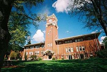
Eastern Washington hosts a number of world-renowned universities including three of the state's five public universities.
Public institutions
- Central Washington University
- Eastern Washington University
- Washington State University
- A number of local community colleges including:
Private institutions
- Gonzaga University
- Heritage University
- Pacific Northwest University of Health Sciences
- Walla Walla University
- Whitman College
- Whitworth University
Research institutions
- Pacific Northwest National Laboratory
- Chimpanzee and Human Communication Institute at Central Washington University
Images
 The Palouse Hills of southeastern Washington
 Dry Falls in the semi-desert Channeled Scablands that dominate much of eastern Washington.
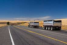 Truck transport in the wheat farming region of Eastern Washington
 Apple orchards in Azwell, Washington surrounding a community of pickers' cabins
Notes
- ↑ "RICHLAND, WASHINGTON (457015)". Western Regional Climate Center. Retrieved April 25, 2016.
- ↑ "NOWData - NOAA Online Weather Data". NOAA. Retrieved June 15, 2015.
- ↑ "NowData – NOAA Online Weather Data". National Oceanic and Atmospheric Administration. Retrieved 2012-02-15.
- ↑ "Climatological Normals of Spokane". Hong Kong Observatory. Retrieved 2010-05-15.
- ↑ WSP Eastside Recruiter Returns to Face Recruitment Challenge, Washington State Patrol Government and Media Relations, September 8, 2010, retrieved 2010-12-27
- ↑ "Eastside steelheading enters last month". Bellingham Herald. March 4, 2010. Retrieved 2010-12-27.
- ↑ "Eastside Earthquakes Get Attention At Conference In Yakima". Oregon Public Broadcasting. October 17, 2007. Retrieved 2010-12-27.
- ↑ Population figures are the most recent figures contained in the respective Wikipedia articles, or in the List of cities in Washington.