Yarrow Point, Washington
| Yarrow Point, Washington | |
|---|---|
| Town | |
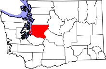
 Location of Yarrow Point, Washington | |
| Coordinates: 47°38′39″N 122°13′0″W / 47.64417°N 122.21667°WCoordinates: 47°38′39″N 122°13′0″W / 47.64417°N 122.21667°W | |
| Country | United States |
| State | Washington |
| County | King |
| Area[1] | |
| • Total | 0.36 sq mi (0.93 km2) |
| • Land | 0.36 sq mi (0.93 km2) |
| • Water | 0 sq mi (0 km2) |
| Elevation | 125 ft (38 m) |
| Population (2010)[2] | |
| • Total | 1,001 |
| • Estimate (2015)[3] | 1,081 |
| • Density | 2,780.6/sq mi (1,073.6/km2) |
| Time zone | Pacific (PST) (UTC-8) |
| • Summer (DST) | PDT (UTC-7) |
| ZIP code | 98004 |
| Area code(s) | 425 |
| FIPS code | 53-80150 |
| GNIS feature ID | 1510418[4] |
| Website | ci.yarrow-point.wa.us |
Yarrow Point is a town in King County, Washington, United States. The population was 1,001 at the 2010 census.
Based on per capita income, one of the more reliable measures of affluence, Yarrow Point ranks fifth of 522 areas in the state of Washington to be ranked.
History
Yarrow Point was officially incorporated on June 15, 1959.
Geography
Yarrow Point is located at 47°38′39″N 122°13′0″W / 47.64417°N 122.21667°W (47.644212, -122.216684).[5]
According to the United States Census Bureau, the town has a total area of 0.36 square miles (0.93 km2), all of it land.[1]
Politics
On the national level, Yarrow Point leans toward the Republican Party. In 2004, Republican George W. Bush received 52 percent of the vote here, defeating Democrat John Kerry, who received around 47 percent.
Demographics
| Historical population | |||
|---|---|---|---|
| Census | Pop. | %± | |
| 1960 | 766 | — | |
| 1970 | 1,101 | 43.7% | |
| 1980 | 1,064 | −3.4% | |
| 1990 | 962 | −9.6% | |
| 2000 | 1,008 | 4.8% | |
| 2010 | 1,001 | −0.7% | |
| Est. 2015 | 1,081 | [6] | 8.0% |
| U.S. Decennial Census[7] 2015 Estimate[3] | |||
2010 census
As of the census[2] of 2010, there were 1,001 people, 374 households, and 299 families residing in the town. The population density was 2,780.6 inhabitants per square mile (1,073.6/km2). There were 407 housing units at an average density of 1,130.6 per square mile (436.5/km2). The racial makeup of the town was 86.4% White, 0.1% African American, 0.2% Native American, 8.8% Asian, 0.7% from other races, and 3.8% from two or more races. Hispanic or Latino of any race were 1.6% of the population.
There were 374 households of which 39.8% had children under the age of 18 living with them, 72.5% were married couples living together, 5.6% had a female householder with no husband present, 1.9% had a male householder with no wife present, and 20.1% were non-families. 17.4% of all households were made up of individuals and 10.4% had someone living alone who was 65 years of age or older. The average household size was 2.68 and the average family size was 3.04.
The median age in the town was 46.8 years. 27.7% of residents were under the age of 18; 3.6% were between the ages of 18 and 24; 15.7% were from 25 to 44; 33.5% were from 45 to 64; and 19.6% were 65 years of age or older. The gender makeup of the town was 49.6% male and 50.4% female.
2000 census
As of the census of 2000, there were 1,008 people, 379 households, and 308 families residing in the town. The population density was 2,720.3 people per square mile (1,051.9/km²). There were 393 housing units at an average density of 1,060.6 per square mile (410.1/km²). The racial makeup of the town was 93.65% White, 0.79% African American, 3.17% Asian, 0.69% from other races, and 1.69% from two or more races. Hispanic or Latino of any race were 1.98% of the population.
There were 379 households out of which 34.6% had children under the age of 18 living with them, 78.4% were married couples living together, 1.6% had a female householder with no husband present, and 18.5% were non-families. 15.3% of all households were made up of individuals and 7.7% had someone living alone who was 65 years of age or older. The average household size was 2.66 and the average family size was 2.96.
In the town the population was spread out with 25.9% under the age of 18, 3.7% from 18 to 24, 20.9% from 25 to 44, 30.9% from 45 to 64, and 18.7% who were 65 years of age or older. The median age was 45 years. For every 100 females there were 102.0 males. For every 100 females age 18 and over, there were 95.5 males.
The median income for a household in the town was $117,940, and the median income for a family was $126,075. Males had a median income of $100,000 versus $52,500 for females. The per capita income for the town was $72,135. About 1.6% of families and 3.4% of the population were below the poverty line, including 6.4% of those under age 18 and none of those age 65 or over.
Gallery
 Yarrow Point Town Hall
 Yarrow Point Water Fountain
 On NE 42nd Pl. looking east near a dock
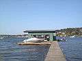 At a dock at the end of NE 42nd Pl. in Yarrow Point.
References
- 1 2 "US Gazetteer files 2010". United States Census Bureau. Retrieved 2012-12-19.
- 1 2 "American FactFinder". United States Census Bureau. Retrieved 2012-12-19.
- 1 2 "Population Estimates". United States Census Bureau. Retrieved July 12, 2016.
- ↑ "Yarrow Point". Geographic Names Information System. United States Geological Survey.
- ↑ "US Gazetteer files: 2010, 2000, and 1990". United States Census Bureau. 2011-02-12. Retrieved 2011-04-23.
- ↑ "Annual Estimates of the Resident Population for Incorporated Places: April 1, 2010 to July 1, 2015". Retrieved July 2, 2016.
- ↑ United States Census Bureau. "Census of Population and Housing". Retrieved July 31, 2013.
External links
Municipalities and communities of King County, Washington, United States | ||
|---|---|---|
| Cities |
|  |
| Towns | ||
| CDPs |
| |
| Unincorporated communities | ||
| Indian reservation | ||
| Ghost towns | ||
| Footnotes | ‡This populated place also has portions in an adjacent county or counties | |