Shoreline, Washington
| Shoreline, Washington | |
|---|---|
| City | |
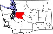
 Location of Shoreline, Washington | |
| Coordinates: 47°45′23″N 122°20′23″W / 47.75639°N 122.33972°WCoordinates: 47°45′23″N 122°20′23″W / 47.75639°N 122.33972°W | |
| Country | United States |
| State | Washington |
| County | King |
| Government | |
| • Mayor | Chris Roberts [1] |
| Area[2] | |
| • Total | 11.70 sq mi (30.30 km2) |
| • Land | 11.67 sq mi (30.23 km2) |
| • Water | 0.03 sq mi (0.08 km2) |
| Elevation | 476 ft (145 m) |
| Population (2010)[3] | |
| • Total | 53,007 |
| • Estimate (2015)[4] | 55,439 |
| • Rank | US: 677th |
| • Density | 4,542.2/sq mi (1,753.8/km2) |
| Time zone | Pacific (PST) (UTC-8) |
| • Summer (DST) | PDT (UTC-7) |
| ZIP codes | 98133, 98155, 98177 |
| Area code(s) | 206 |
| FIPS code | 53-63960 |
| GNIS feature ID | 1699810[5] |
| Website | www.shorelinewa.gov |
Shoreline is a city in King County, Washington, United States, 9 miles (14 km) north of Downtown Seattle bordering the northern Seattle city limits. As of the 2010 census, the population was 53,007, making it the 20th largest city in the state of Washington.
Based on per capita income, one of the more reliable measures of affluence, Shoreline ranks 91st of 522 areas in the state of Washington to be ranked.
If its offer to annex Point Wells is accepted by the developer, Shoreline will extend into south Snohomish County.[6]
History
Shoreline began in 1890 with the platting of the neighborhood of Richmond Beach, on Puget Sound, in anticipation of the arrival of the Great Northern Railway the next year. Over the next two decades, Shoreline was connected to Seattle via the Seattle-Everett Interurban streetcar line (1906) and a newly paved North Trunk Road (now Aurora Avenue N., State Route 99) (1913), helping to increase its population.
The name "Shoreline" first came to be applied to this stretch of unincorporated King County in 1944 when it was given to the school district, since the school district boundaries stretched from "Shore to Shore" (Puget Sound to Lake Washington) and "Line to Line" (the old Seattle city limit of 85th St to the Snohomish County Line). Though the modern borders of the city do not stretch to Lake Washington, the area kept the "Shoreline" name.
After the incorporation of Lake Forest Park in 1961, the remainder of the Shoreline School District remained an unincorporated portion of King County. Fifty-one years after it had been named, on August 31, 1995 Shoreline was officially incorporated as a code city and adopted the council-manager form of government. (See City government in the state of Washington.) Residents used Seattle, WA as their address only until 1995 when the city was formed and addresses changed to Shoreline, WA.
In January 2016, Chris Roberts was elected mayor and is the city's first Native American mayor in its history.
Police
Shoreline contracts with the King County Sheriff's Office for police services. Deputies assigned to Shoreline wear city uniforms and drive patrol cars marked with the city logo. As of 2012, there are 52 full-time employees assigned to the Shoreline Police Department.[7] The Shoreline Police Department has a burglary/larceny unit, traffic unit, and a street crimes unit.[8]
Geography
Shoreline is located at 47°45′23″N 122°20′23″W / 47.75639°N 122.33972°W (47.756519, -122.339657).[9]
According to the United States Census Bureau, the city has a total area of 11.70 square miles (30.30 km2), of which, 11.67 square miles (30.23 km2) is land and 0.03 square miles (0.08 km2) is water.[2] The city of Shoreline also contains a gated community, The Highlands, which manages its own utilities separately from Shoreline. The Richmond Beach neighborhood occupies the northwest corner of the city, around 47°46′10″N 122°23′24″W / 47.7695415°N 122.3901313°W.[10][11]
There are 330 acres (1.3 km²) of park land in Shoreline, divided among 25 parks. Boeing Creek and Shoreview Park, which abut Shoreline Community College, contain a ravine through which flows Boeing Creek on its way to Hidden Lake and Puget Sound.
Demographics
| Historical population | |||
|---|---|---|---|
| Census | Pop. | %± | |
| 1990 | 52,109 | — | |
| 2000 | 53,025 | 1.8% | |
| 2010 | 53,007 | 0.0% | |
| Est. 2015 | 55,439 | [12] | 4.6% |
| U.S. Decennial Census[13] 2015 Estimate[4] | |||
2010 census
As of the census[3] of 2010, there were 53,007 people, 21,561 households, and 13,168 families residing in the city. The population density was 4,542.2 inhabitants per square mile (1,753.8/km2). There were 22,787 housing units at an average density of 1,952.6 per square mile (753.9/km2). The racial makeup of the city was 71.4% White, 5.0% African American, 0.8% Native American, 15.2% Asian, 0.3% Pacific Islander, 2.2% from other races, and 5.1% from two or more races. Hispanic or Latino of any race were 6.6% of the population.
There were 21,561 households of which 27.9% had children under the age of 18 living with them, 46.4% were married couples living together, 10.3% had a female householder with no husband present, 4.4% had a male householder with no wife present, and 38.9% were non-families. 29.7% of all households were made up of individuals and 10.4% had someone living alone who was 65 years of age or older. The average household size was 2.39 and the average family size was 2.96.
The median age in the city was 42.1 years. 19.1% of residents were under the age of 18; 8.2% were between the ages of 18 and 24; 26.7% were from 25 to 44; 30.9% were from 45 to 64; and 15.2% were 65 years of age or older. The gender makeup of the city was 48.7% male and 51.3% female.
2000 census
As of the census of 2000, there were 53,025 people, 20,716 households, and 13,486 families residing in the city. The population density was 4,546.0 people per square mile (1,755.8/km²). There were 21,338 housing units at an average density of 1,829.4 per square mile (706.6/km²). The racial makeup of the city was 76.99% White, 2.77% African American, 0.91% Native American, 13.23% Asian, 0.32% Pacific Islander, 1.51% from other races, and 4.27% from two or more races. Hispanic or Latino of any race were 3.87% of the population.
There were 20,716 households out of which 30.6% had children under the age of 18 living with them, 51.2% were married couples living together, 10.0% had a female householder with no husband present, and 34.9% were non-families. 26.4% of all households were made up of individuals and 9.1% had someone living alone who was 65 years of age or older. The average household size was 2.50 and the average family size was 3.03.
In the city the population was spread out with 22.5% under the age of 18, 7.7% from 18 to 24, 30.4% from 25 to 44, 24.8% from 45 to 64, and 14.5% who were 65 years of age or older. The median age was 39 years. For every 100 females there were 93.2 males. For every 100 females age 18 and over, there were 90.1 males.
The median income for a household in the city was $51,658, and the median income for a family was $61,450. Males had a median income of $40,955 versus $33,165 for females. The per capita income for the city was $24,959. About 4.4% of families and 6.9% of the population were below the poverty line, including 6.1% of those under age 18 and 7.3% of those age 65 or over.
Neighborhoods
The city of Shoreline is divided into 14 separate neighborhoods plotted out by the city. The neighborhoods range from Richmond Beach in the northwest to Briarcrest in the southeast.[14][15]
City landmarks
The City of Shoreline has designated the following landmarks:
| Landmark | Built | Listed | Address | Photo |
|---|---|---|---|---|
| William E. Boeing House[16] | 1914 | 1994 | The Highlands | |
| Crawford Store (Godfrey Building)[16] | 1922 | 1985 | 2411 NW 195th Place |
In addition, the city designates the following "community landmark":
| Landmark | Built | Listed | Address | Photo |
|---|---|---|---|---|
| Ronald Grade School[16] | 1912 | 1995 | 749 N 175th Street |  |
Points of interest
- Hamlin Park
- Kruckeberg Botanic Garden
- Shoreline Historical Museum
- Shoreline Stadium
- Boeing Creek and Shoreview Park
Sister city
Education
School districts
Colleges
References
- ↑ http://www.cityofshoreline.com/index.aspx?page=80
- 1 2 "US Gazetteer files 2010". United States Census Bureau. Archived from the original on January 24, 2012. Retrieved 2012-12-19.
- 1 2 "American FactFinder". United States Census Bureau. Retrieved 2012-12-19.
- 1 2 "Population Estimates". United States Census Bureau. Retrieved June 15, 2016.
- ↑ "Shoreline". Geographic Names Information System. United States Geological Survey.
- ↑ "Shoreline offers to annex planned Point Wells development". The Seattle Times. August 30, 2011.
- ↑ "City of Shoreline Police Service Report 2012" (PDF). Chief Shawn Ledford, City of Shoreline Police Department. Retrieved 2013-02-27.
- ↑ "Police Department". Retrieved 2013-02-27.
- ↑ "US Gazetteer files: 2010, 2000, and 1990". United States Census Bureau. 2011-02-12. Retrieved 2011-04-23.
- ↑ "Richmond Beach". Geographic Names Information System. United States Geological Survey. Retrieved 2013-01-09.
- ↑ "Map of Richmond Beach". Richmond Beach Community Association. Retrieved 2013-01-09.
- ↑ "Annual Estimates of the Resident Population for Incorporated Places: April 1, 2010 to July 1, 2015". Retrieved July 2, 2016.
- ↑ United States Census Bureau. "Census of Population and Housing". Archived from the original on May 11, 2015. Retrieved July 24, 2013.
- ↑ "Neighborhood Association Contacts". City of Shoreline. Retrieved 2013-03-30.
- ↑ "Neighborhoods Map" (PDF). City of Shoreline. Retrieved 2013-03-30.
- 1 2 3 King County and Local Landmarks List, King County (undated, last modified 2003-02-26). Accessed online 2009-05-08.
External links
- City of Shoreline
- The Shoreline Historical Museum
- SCC Wiki entry
- Shoreline News, KOMO
- Shoreline Wiki
Municipalities and communities of King County, Washington, United States | ||
|---|---|---|
| Cities |
|  |
| Towns | ||
| CDPs |
| |
| Unincorporated communities | ||
| Indian reservation | ||
| Ghost towns | ||
| Footnotes | ‡This populated place also has portions in an adjacent county or counties | |
 |
Edmonds / Woodway | Edmonds | Mountlake Terrace | |
| Puget Sound | |
Lake Forest Park | ||
| ||||
| | ||||
| Puget Sound / Seattle | Seattle | Seattle |