Washington State Route 522
| ||||
|---|---|---|---|---|
|
Map of western Washington with SR 522 highlighted in red | ||||
| Route information | ||||
| Auxiliary route of I‑5 | ||||
| Defined by RCW 47.17.725 | ||||
| Maintained by WSDOT | ||||
| Length: | 24.64 mi[1] (39.65 km) | |||
| Existed: | 1964[2] – present | |||
| Major junctions | ||||
| West end: |
| |||
| ||||
| East end: |
| |||
| Location | ||||
| Counties: | King, Snohomish | |||
| Highway system | ||||
| ||||

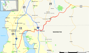
State Route 522 (SR 522) connects Seattle to its northeastern suburbs. Its southern origin is at Interstate 5 at the north end of the Roosevelt neighborhood in north Seattle, where it is a city arterial, Lake City Way N.E. Upon crossing the Seattle city limits into Lake Forest Park, its name changes to Bothell Way N.E. It continues through Kenmore and into Bothell, where part of it is designated Woodinville Drive. East of downtown Bothell, SR 522 becomes a freeway as the first segment of the Bothell-Monroe Highway. It continues through Woodinville to an at-grade intersection with Paradise Lake Road. From there, it continues east as a two-lane freeway into unincorporated Snohomish County to Monroe, where it ends at the junction with U.S. Route 2. It is about 25 miles (40 km) long in total.
History
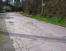
Once called the Red Brick Road, SR 522 originally connected Downtown Seattle to the towns of Lake City, Lake Forest Park, Kenmore, Bothell, Redmond, Fall City and points east. From 1926 to 1930, U.S. Route 99 followed the present day SR 522 from Seattle to SR 527.[3] Rebuilt and expanded after World War II, it remained a connector from downtown Seattle through to Redmond until the construction of Interstate 5, when its origination point moved several miles north along that freeway into the Roosevelt neighborhood of Seattle.
After 1970, the easternmost portion of SR 522 from Bothell to Woodinville, Redmond, and North Bend was renumbered as State Route 202, and the portion of what had been SR 202 between Bothell and Monroe was renumbered as SR 522. A highly utilized bypass to reach Stevens Pass, 1,780 accidents, 1,359 injuries, and 47 deaths in 15 years resulted in the highway being included in the September 1995 Reader's Digest article "America's Most Dangerous Highways." The route has also been featured in a Dateline NBC story and a 2007 Forbes magazine[4] article for similar reasons.
Recent developments
A highway interchange with entrance and exit on and off ramps was constructed and completed in August 2006 to replace the signalized intersection that existed before.
A section of the two lane undivided highway was expanded to four lanes with a median to separate opposing lanes of traffic and a new bridge was built across the Snohomish River. This project is fully funded by the 2003 Nickel Gas Tax passed by the Washington State Legislature and was declared completed December 15, 2014, although construction work continued on nearly a daily basis for at least 6 months after that declaration.[5]
A bus rapid transit line is proposed for SR 522 from NE 145 St. to Bothell as part of the Sound Transit 3 ballot measure.
Major intersections
| County | Location | mi[1] | km | Destinations | Notes | ||
|---|---|---|---|---|---|---|---|
| King | Seattle | 0.00 | 0.00 | Interchange; westbound exit and eastbound entrance | |||
| 0.34– 0.41 | 0.55– 0.66 | Interchange; westbound exit and eastbound entrance | |||||
| 3.21 | 5.17 | Northeast 125th Street | Former SR 513 | ||||
| 4.22 | 6.79 | ||||||
| Lake Forest Park | 5.85 | 9.41 | |||||
| Bothell | 9.77 | 15.72 | Bothell Way – Everett | Former SR 527 | |||
| West end of freeway | |||||||
| 11.06 | 17.80 | ||||||
| Woodinville | 12.01 | 19.33 | |||||
| 12.90 | 20.76 | Northeast 195th Street – Duvall | Eastbound exit and westbound entrance | ||||
| Snohomish | | 14.05 | 22.61 | ||||
| East end of freeway, west end of divided highway | |||||||
| Maltby | 16.56 | 26.65 | At-grade intersection | ||||
| East end of divided highway | |||||||
| | 18.58 | 29.90 | Fales Road, Echo Lake Road | ||||
| Monroe | 24.14 | 38.85 | West Main Street – Monroe | ||||
| 24.64 | 39.65 | ||||||
| 1.000 mi = 1.609 km; 1.000 km = 0.621 mi | |||||||
References
- 1 2 Finch, Mark, ed. (March 4, 2014). State Highway Log: Planning Report 2013, SR 2 to SR 971 (PDF) (Report). Washington State Department of Transportation. pp. 1620–1632. Retrieved May 28, 2014.
- ↑ "47.17.725: State route No. 522". Revised Code of Washington. Washington State Legislature. 1970. Retrieved May 28, 2014.
- ↑ US 99 Trunk - Highways of Washington State; Retrieved June 25, 2012
- ↑ "America's Killer Roads". Forbes. Retrieved July 18, 2007.
- ↑ Washington State Department of Transportation,