Riverton, Washington
| Riverton, Washington | |
|---|---|
| CDP | |
|
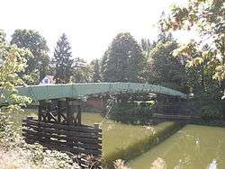
The 119th Street footbridge over the upper portion of the Duwamish River leading to historic Riverton. Seen here from the Allentown side. | |
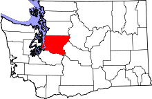
 Riverton, Washington Location of Riverton, Washington. | |
| Coordinates: 47°29′41″N 122°18′40″W / 47.49472°N 122.31111°WCoordinates: 47°29′41″N 122°18′40″W / 47.49472°N 122.31111°W | |
| Country | United States |
| State | Washington |
| County | King |
| Area | |
| • Total | 1.182 sq mi (3.061 km2) |
| • Land | 1.182 sq mi (3.061 km2) |
| • Water | 0.000 sq mi (0.000 km2) |
| Population (2010) | |
| • Total | 6,407 |
| • Density | 5,420.5/sq mi (2,092.9/km2) |
| Time zone | Pacific (PST) (UTC-8) |
| • Summer (DST) | PDT (UTC-7) |
| GNIS feature ID | 1507825[1] |
Riverton is a census-designated place (CDP) in King County, Washington, United States. The population was 6,407 at the 2010 census. Riverton was formerly part of the Riverton-Boulevard Park CDP, which was split up for the 2010 census into Riverton and Boulevard Park.[2]
Riverton also refers to a neighboring former community in part of what is now Tukwila in the Duwamish River Valley. It was on the left bank of the Duwamish, not far from the location on the right bank of the present-day Tukwila Community Center.[3]
History
Riverton lent its name to an early 20th-century bridge, variously known as the Riverton Draw Bridge, the Riverton Drawspan, and King County Bridge 622-A. Built 1903, the bridge developed a reputation for being rather unsafe. It closed to vehicles 1919, and was demolished 1927. A remnant of the central pier can still be seen in the river as of 2009, visible either from the riverbank[4] or from the 119th St. S. pedestrian bridge or the Allentown Bridge.[5]
Geography
Riverton is located at 47°29′41″N 122°18′40″W / 47.49472°N 122.31111°W (47.494614, -122.311248).[6]
According to the United States Census Bureau, the CDP had a total area of 1.182 square miles (3.061 km²), of which, 1.182 square miles (3.061 km²) of it is land and 0.000 square miles (0.000 km²) of it (0%) is water.
References
- ↑ "Riverton". Geographic Names Information System. United States Geological Survey.
- ↑ "Washington: 2010 Population and Housing Unit Counts" (PDF). United States Census Bureau. Retrieved 26 February 2013.
- ↑ The Green-Duwamish River: Connecting people with a diverse environment. Duwamish River Cleanup Coalition/TAG. No date, appears to be 2008 or 2009.
- ↑ Paula Becker, Riverton Draw Bridge is built across the Duwamish River in 1903, HistoryLink, October 16, 2003. Accessed online 2009-04-16.
- ↑ Photo from 119th St. S. pedestrian bridge, Photo from Green River Trail below Allentown Bridge.
- ↑ "US Gazetteer files: 2010, 2000, and 1990". United States Census Bureau. 2011-02-12. Retrieved 2011-04-23.
Municipalities and communities of King County, Washington, United States | ||
|---|---|---|
| Cities |
|  |
| Towns | ||
| CDPs |
| |
| Unincorporated communities | ||
| Indian reservation | ||
| Ghost towns | ||
| Footnotes | ‡This populated place also has portions in an adjacent county or counties | |