La Côte-Saint-André
| La Côte-Saint-André | ||
|---|---|---|
|
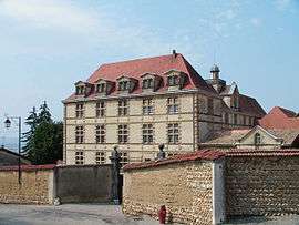
The château in La Côte-Saint-André | ||
| ||
 La Côte-Saint-André | ||
|
Location within Auvergne-Rhône-Alpes region  La Côte-Saint-André | ||
| Coordinates: 45°23′40″N 5°15′41″E / 45.3944°N 5.2614°ECoordinates: 45°23′40″N 5°15′41″E / 45.3944°N 5.2614°E | ||
| Country | France | |
| Region | Auvergne-Rhône-Alpes | |
| Department | Isère | |
| Arrondissement | Vienne | |
| Canton | Côte-Saint-André | |
| Intercommunality | Pays de Bièvre-Liers | |
| Government | ||
| • Mayor (2014–2020) | Joël Gullon | |
| Area1 | 27.93 km2 (10.78 sq mi) | |
| Population (2011)2 | 4,886 | |
| • Density | 170/km2 (450/sq mi) | |
| Time zone | CET (UTC+1) | |
| • Summer (DST) | CEST (UTC+2) | |
| INSEE/Postal code | 38130 / 38260 | |
| Elevation | 335–582 m (1,099–1,909 ft) | |
|
1 French Land Register data, which excludes lakes, ponds, glaciers > 1 km² (0.386 sq mi or 247 acres) and river estuaries. 2 Population without double counting: residents of multiple communes (e.g., students and military personnel) only counted once. | ||

La Côte-Saint-André is a commune in the Isère department in southeastern France.
Populations
| Historical population | ||
|---|---|---|
| Year | Pop. | ±% |
| 1793 | 3,381 | — |
| 1806 | 3,890 | +15.1% |
| 1821 | 3,893 | +0.1% |
| 1831 | 4,568 | +17.3% |
| 1841 | 4,083 | −10.6% |
| 1851 | 4,429 | +8.5% |
| 1861 | 4,616 | +4.2% |
| 1872 | 4,346 | −5.8% |
| 1881 | 4,193 | −3.5% |
| 1891 | 4,015 | −4.2% |
| 1901 | 3,900 | −2.9% |
| 1911 | 3,378 | −13.4% |
| 1921 | 3,126 | −7.5% |
| 1931 | 3,720 | +19.0% |
| 1946 | 3,656 | −1.7% |
| 1954 | 3,780 | +3.4% |
| 1962 | 3,623 | −4.2% |
| 1968 | 3,522 | −2.8% |
| 1975 | 3,865 | +9.7% |
| 1982 | 3,857 | −0.2% |
| 1990 | 3,966 | +2.8% |
| 1999 | 4,240 | +6.9% |
| 2009 | 4,810 | +13.4% |
| 2011 | 4,886 | +1.6% |
Personalities
- Hector Berlioz was born here.
See also
References
| Wikimedia Commons has media related to La Côte-Saint-André. |
This article is issued from Wikipedia - version of the 2/12/2016. The text is available under the Creative Commons Attribution/Share Alike but additional terms may apply for the media files.