Auberives-en-Royans
| Auberives-en-Royans | |
|---|---|
|
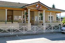
The Town Hall | |
 Auberives-en-Royans | |
|
Location within Auvergne-Rhône-Alpes region  Auberives-en-Royans | |
| Coordinates: 45°03′51″N 5°18′07″E / 45.0642°N 5.3019°ECoordinates: 45°03′51″N 5°18′07″E / 45.0642°N 5.3019°E | |
| Country | France |
| Region | Auvergne-Rhône-Alpes |
| Department | Isère |
| Arrondissement | Grenoble |
| Canton | Pont en Roya |
| Intercommunality | Bourne à l'Isère |
| Government | |
| • Mayor (20014–2020) | Stéphane Villard |
| Area1 | 5.07 km2 (1.96 sq mi) |
| Population (2010)2 | 359 |
| • Density | 71/km2 (180/sq mi) |
| Time zone | CET (UTC+1) |
| • Summer (DST) | CEST (UTC+2) |
| INSEE/Postal code | 38018 / 38680 |
| Elevation | 170–330 m (560–1,080 ft) |
|
1 French Land Register data, which excludes lakes, ponds, glaciers > 1 km² (0.386 sq mi or 247 acres) and river estuaries. 2 Population without double counting: residents of multiple communes (e.g., students and military personnel) only counted once. | |
Auberives-en-Royans is a French commune in the Isère department in the Auvergne-Rhône-Alpes region of south-eastern France.
The inhabitants of the commune are known as Albaripains or Albaripaines.[1]
Geography
Auberives-en-Royans is located at the foot of the Vercors plateau in the Isère valley some 19 km east of Romans-sur-Isère and 11 km south of Saint-Marcellin. The southern border of the commune is the border between Isère and Drôme departments. Access to the commune is by the D531 road which branches from the D1532 east of Saint-Nazaire-en-Royans which passes through the south of the commune and the village and continues along the southern border east to Pont-en-Royans. The D518 road comes from Saint-Romans in the north and passes down the eastern border of the commune to Pont-en-Royans. The commune has some forests in the north and the rest is farmland.[2]
The southern border of the commune consists entirely of the Bourne river as it flows west to join the Isère at Saint-Nazaire-en-Royans. The Tarze river flows through the centre of the commune from the north and joins the Bourne near the village. The Canal de la Bourne starts in the south-west of the commune and flows through the commune parallel to the Bourne towards the Isère.[2]
Neighbouring communes and villages[2]
 |
Saint-Just-de-Claix | Saint-Romans | Saint-André-en-Royans | |
| Saint-Nazaire-en-Royans | |
Pont-en-Royans | ||
| ||||
| | ||||
| La Motte-Fanjas | Saint-Thomas-en-Royans | Sainte-Eulalie-en-Royans |
Administration
List of Successive Mayors[3]
| From | To | Name | Party | Position |
|---|---|---|---|---|
| 2008 | 2014 | Bernard Perazio | ||
| 2014 | 2020 | Stéphane Villard |
(Not all data is known)
Demography
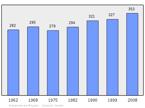
In 2010 the commune had 359 inhabitants. The evolution of the number of inhabitants is known from the population censuses conducted in the commune since 1793. From the 21st century, a census of communes with fewer than 10,000 inhabitants is held every five years, unlike larger towns that have a sample survey every year.[Note 1]
| 1793 | 1800 | 1806 | 1821 | 1831 | 1836 | 1841 | 1846 | 1851 |
|---|---|---|---|---|---|---|---|---|
| 275 | 300 | 309 | 327 | 314 | 341 | 334 | 345 | 344 |
| 1856 | 1861 | 1866 | 1872 | 1876 | 1881 | 1886 | 1891 | 1896 |
|---|---|---|---|---|---|---|---|---|
| 329 | 349 | 352 | 332 | 456 | 335 | 349 | 354 | 377 |
| 1901 | 1906 | 1911 | 1921 | 1926 | 1931 | 1936 | 1946 | 1954 |
|---|---|---|---|---|---|---|---|---|
| 412 | 422 | 422 | 335 | 352 | 377 | 340 | 286 | 295 |
| 1962 | 1968 | 1975 | 1982 | 1990 | 1999 | 2006 | 2010 | - |
|---|---|---|---|---|---|---|---|---|
| 282 | 295 | 279 | 294 | 321 | 327 | 350 | 359 | - |
Sources : Ldh/EHESS/Cassini until 1962, INSEE database from 1968 (population without double counting and municipal population from 2006)
Sites and monuments
- A Church from the 19th century
- A Fortified house
See also
External links
- Auberives-en-Royans on Google Maps
- Auberives-en-Royans on Géoportail, National Geographic Institute (IGN) website (French)
- Anberive en Royans on the 1750 Cassini Map
- Auberives-en-Royans on the INSEE website (French)
- INSEE (French)
Notes and references
Notes
- ↑ At the beginning of the 21st century, the methods of identification have been modified by Law No. 2002-276 of 27 February 2002, the so-called "law of local democracy" and in particular Title V "census operations" allows, after a transitional period running from 2004 to 2008, the annual publication of the legal population of the different French administrative districts. For communes with a population greater than 10,000 inhabitants, a sample survey is conducted annually, the entire territory of these communes is taken into account at the end of the period of five years. The first "legal population" after 1999 under this new law came into force on 1 January 2009 and was based on the census of 2006.
References
- ↑ Inhabitants of Isère (French)
- 1 2 3 Google Maps
- ↑ List of Mayors of France (French)
| Wikimedia Commons has media related to Auberives-en-Royans. |