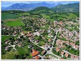
Jarrie
| Jarrie | ||
|---|---|---|
 | ||
| ||
 Jarrie | ||
|
Location within Auvergne-Rhône-Alpes region  Jarrie | ||
| Coordinates: 45°06′43″N 5°45′39″E / 45.1119°N 05.7607°ECoordinates: 45°06′43″N 5°45′39″E / 45.1119°N 05.7607°E | ||
| Country | France | |
| Region | Auvergne-Rhône-Alpes | |
| Department | Isère | |
| Arrondissement | Grenoble | |
| Canton | Vizille | |
| Intercommunality | Sud Grenoblois | |
| Government | ||
| • Mayor (2014–2020) | Raphaël Guerrero | |
| Area1 | 13.26 km2 (5.12 sq mi) | |
| Population (2011)2 | 2,845 | |
| • Density | 210/km2 (560/sq mi) | |
| Time zone | CET (UTC+1) | |
| • Summer (DST) | CEST (UTC+2) | |
| INSEE/Postal code | 38200 / 38560 | |
| Elevation | 259–733 m (850–2,405 ft) | |
|
1 French Land Register data, which excludes lakes, ponds, glaciers > 1 km² (0.386 sq mi or 247 acres) and river estuaries. 2 Population without double counting: residents of multiple communes (e.g., students and military personnel) only counted once. | ||

Jarrie is a commune in the Isère department in southeastern France.
Population
| Historical population | ||
|---|---|---|
| Year | Pop. | ±% |
| 1793 | 839 | — |
| 1806 | 963 | +14.8% |
| 1821 | 1,030 | +7.0% |
| 1831 | 1,104 | +7.2% |
| 1841 | 1,067 | −3.4% |
| 1851 | 971 | −9.0% |
| 1861 | 935 | −3.7% |
| 1872 | 898 | −4.0% |
| 1881 | 967 | +7.7% |
| 1891 | 991 | +2.5% |
| 1901 | 962 | −2.9% |
| 1911 | 1,020 | +6.0% |
| 1921 | 1,176 | +15.3% |
| 1931 | 1,438 | +22.3% |
| 1946 | 1,523 | +5.9% |
| 1954 | 1,904 | +25.0% |
| 1962 | 2,167 | +13.8% |
| 1968 | 2,084 | −3.8% |
| 1975 | 2,009 | −3.6% |
| 1982 | 2,807 | +39.7% |
| 1990 | 3,809 | +35.7% |
| 1999 | 4,009 | +5.3% |
| 2009 | 3,812 | −4.9% |
| 2011 | 3,845 | +0.9% |
Twin towns
Jarrie is twinned with:
-
 Macael, Spain, since 1989
See also
References
| Wikimedia Commons has media related to Jarrie. |
This article is issued from Wikipedia - version of the 10/28/2016. The text is available under the Creative Commons Attribution/Share Alike but additional terms may apply for the media files.