Beaujeu, Alpes-de-Haute-Provence
| Beaujeu | ||
|---|---|---|
|
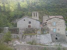
The church in Beaujeu | ||
| ||
 Beaujeu | ||
|
Location within Provence-A.-C.d'A. region  Beaujeu | ||
| Coordinates: 44°12′15″N 6°22′20″E / 44.2042°N 6.3722°ECoordinates: 44°12′15″N 6°22′20″E / 44.2042°N 6.3722°E | ||
| Country | France | |
| Region | Provence-Alpes-Côte d'Azur | |
| Department | Alpes-de-Haute-Provence | |
| Arrondissement | Digne-les-Bains | |
| Canton | La Javie | |
| Intercommunality | Haute Bléone | |
| Government | ||
| • Mayor (2008–2020) | Brigitte Bonnet | |
| Area1 | 45.68 km2 (17.64 sq mi) | |
| Population (2008)2 | 153 | |
| • Density | 3.3/km2 (8.7/sq mi) | |
| Time zone | CET (UTC+1) | |
| • Summer (DST) | CEST (UTC+2) | |
| INSEE/Postal code | 04024 / 04420 | |
| Elevation |
821–2,153 m (2,694–7,064 ft) (avg. 880 m or 2,890 ft) | |
|
1 French Land Register data, which excludes lakes, ponds, glaciers > 1 km² (0.386 sq mi or 247 acres) and river estuaries. 2 Population without double counting: residents of multiple communes (e.g., students and military personnel) only counted once. | ||
Beaujeu is a French commune in the Alpes-de-Haute-Provence department in the Provence-Alpes-Côte d'Azur region of south-eastern France.[1]
The inhabitants of the commune are known as Beaujolais or Beaujolaises.[2]
Geography
Beaujeu is located some 30 km east of Sisteron and 20 km north-east of Digne-les-Bains at an altitude of 880 m. Access to the commune is by the D900 road from Le Vernet in the north which passes through the length of the commune and continues south to Digne. The commune is rugged and mountainous.[3][4]
An enormous number of streams rise all over the commune which mostly converge on the Arigéol which flows south to join the Bléone at La Javie.[3][4]
Mapping
A list of online mapping systems can be displayed by clicking on the coordinates (latitude and longitude) in the top right hand corner of this article.
Neighbouring communes and villages
 |
Barles | Verdaches | Le Vernet | |
| |
Prads-Haute-Bléone | |||
| ||||
| | ||||
| La Robine-sur-Galabre | La Javie |
Geology
The mountains around Beaujeu are composed of black shale.
Relief
- Blayeul Summit (2189 m) with a radio relay mast
- Chappe summit (1667 m)
- Col du Labouret (1240 m) on the D900 road
Environment
The commune has 2793 hectares of woods and forests - 61% of its area.[5]
Hamlets
- Boullard
- le Clucheret
- l'Escale
- Fonfrède
- le Labouret
- Saint-Pierre
- les Traverses-Hautes
- le Villard
Natural and technological risks
None of the 200 communes in the department is in a no seismic risk zone. The Canton of La Javie to which Beaujeu belongs is in zone 1b (low risk) according to the deterministic classification of 1991 and based on its seismic history and in zone 4 (medium risk) according to the probabilistic classification EC8 of 2011. Beaujeu also faces four other natural hazards:[6]
- Avalanche
- Forest fire
- Flood (in the Arigéol valley)
- Landslide
Beaujeu is also exposed to a risk of technological origin, namely the carriage of dangerous goods on the highway.[6]
There is no plan for prevention of foreseeable natural risks (PPR) for the commune and there is no DICRIM.[6]
The town has been subject to several natural disasters for flooding, mudslides, and landslides in 1986, 1994, and 1996.[7] The landslide on 18 May 1996 carried away two 20,000 volt power pylons.[8]
Toponymy
The term for the locality in 1147 comes from the Latin bellom jugum, meaning "beautiful mountain".[9][10] It then became Bèl jog, a confusion with the Occitan bèl joc which means beau jeu in French.[9]
The name of the hamlet Clucheret seems to come from its status as a parish which would have earned it the name of Clocher (Bell tower).[11]
The name of the Chappe summit (1667 m) which borders Prads-Haute-Bléone is in memory of the existence of a semaphore visual telegraph relay station called telegraph Chappe after Claude Chappe who designed it in 1794.
Beaujeu appears as Beaujou on the 1750 Cassini Map[12] and as Beaujun on the 1790 version.[13]
History
In Ancient times the Bodiontici populated the Bléone valley as well as the Gauls who lived in the current commune of Beaujeu. The Bodiontici were defeated by Augustus at the same time as the other people present on the Tropaeum Alpium before 14 BC. The commune was attached to the province of Alpes-Maritimes at the time of its creation.[14]
According to an inventory of the property of the Abbey of St. Victor, Marseille, the abbey are owned several tenures and bergeries among which la Bouisse, Champ Premier, la Sébière, and Auche can be identified. Later there were three distinct communities, each with its church at Beaujeu, Le Clucheret, and Saint-Pierre-des-Auches. The Church of Saint Peter was originally built higher and the priory depended on the Augustinian Abbey of Valence.[11][15]
The locality appears for the first time in charters of 1147 (Beljog),[16] and a Motte-and-bailey castle was built in the 11th century at a place called La Tour.[17]
The barony of Beaujeu extended over the communities of Mariaud and Clucheiret.[18] A toll was established on the Col de Labouret road at the end of the Middle Ages.[19]
In 1309, William of Roumoules was reported as lord of Roumoules, Beaujeu, Bédéjun, Bras-d'Asse, Entrages, Majastres, Vergons, and Estoublon.[20] The death of Queen Joanna I of Naples reopened a crisis of succession to head the county of Provence and the cities of the Union of Aix (1382-1387) supported Charles, Duke of Durazzo, against Louis I of Anjou. The lord of Beaujeu and Mariaud, Gui Saint-Marcial, supported the Duke of Anjou in spring 1382, this support being conditional on the participation of the Duke in the relief expedition for the Queen.[21]
During the French Revolution the commune had a patriotic society, founded after the end of 1792.[22]
The French coup d'état of 1851 committed by Louis-Napoleon Bonaparte against the French Second Republic provoked an armed uprising in the Lower Alps in defence of the Constitution. After the failure of the uprising there was a severe crackdown on those who stood up to defend the Republic which included one inhabitant of Beaujeu.[23]
As with many communes in the department Beaujeu had a school well before the Jules Ferry laws. In 1775 it already has a school that opened in winter.[11] In 1863 there were four: in the main village and in remote villages (Saint-Pierre, Boulard, and Fontfrède), which provided primary education for boys. No instruction was given to girls: neither the Falloux Laws (1851), which required the opening of a girls' school in communes of over 800 inhabitants nor the first Duruy Law (1867), which lowers the threshold to 500 inhabitants, concerned Beaujeu. The subsidies from the second Duruy Act (1877) were used to build a new school and remodel another. It was only with the Ferry laws that the girls of Beaujeu were regularly educated.[24]
Heraldry
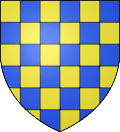 |
Blazon: Chequy, Or and Azure. |
Administration
| From | To | Name | Party | Position |
|---|---|---|---|---|
| 2001 | 2008 | Jean-Pierre Brovelli | ||
| 2008 | 2020 | Brigitte Bonnet |
(Not all data is known)
Demography
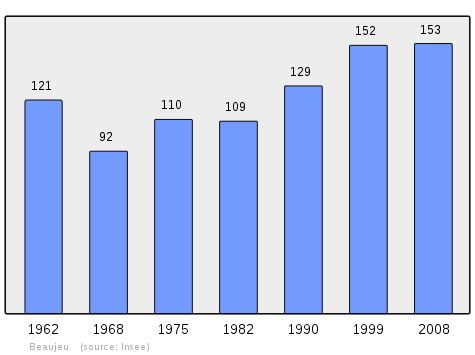
In 2012 the commune had 999 inhabitants. The evolution of the number of inhabitants is known from the population censuses conducted in the commune since 1793. From the 21st century, a census of communes with fewer than 10,000 inhabitants is held every five years, unlike larger communes that have a sample survey every year.[Note 1]
| 1793 | 1800 | 1806 | 1821 | 1831 | 1836 | 1841 | 1846 | 1851 |
|---|---|---|---|---|---|---|---|---|
| 372 | 265 | 334 | 418 | 450 | 408 | 444 | 440 | 415 |
| 1856 | 1861 | 1866 | 1872 | 1876 | 1881 | 1886 | 1891 | 1896 |
|---|---|---|---|---|---|---|---|---|
| 349 | 360 | 340 | 329 | 321 | 302 | 303 | 265 | 261 |
| 1901 | 1906 | 1911 | 1921 | 1926 | 1931 | 1936 | 1946 | 1954 |
|---|---|---|---|---|---|---|---|---|
| 271 | 233 | 252 | 190 | 165 | 143 | 136 | 145 | 131 |
| 1962 | 1968 | 1975 | 1982 | 1990 | 1999 | 2007 | 2012 | - |
|---|---|---|---|---|---|---|---|---|
| 121 | 92 | 110 | 109 | 129 | 152 | 155 | 150 | - |
Sources : Ldh/EHESS/Cassini until 1962, INSEE database from 1968 (population without double counting and municipal population from 2006)
Economy
In 2012 the workforce was 75 people, including 9 unemployed. These people were mostly employees (88%) and most worked outside the commune (68%).[26] On 1 January 2014 there were a total of 12 business enterprises in the commune: 3 in Agriculture, 3 in Trade, transport, and services, and 3 in Administration, education, health, or social services. 3 Agricultural enterprises and one administrative establishment employed staff.[27]
According to the Departmental Observatory of Tourism, tourism is important for the commune with between one and five tourists accommodated per capita. In the total absence of any housing facilities these are second homes that can accommodate tourists. (the 42 second homes account for over a third of the communal housing and have 208 beds).[28]
Culture and heritage
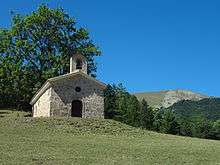
.JPG)
There were two coaching inns on the Labouret road, one in the village and one at the foot of the pass whose slope was very difficult.[29]
Religious heritage
- The Chapel of Saint-Blaise at Clucheret contains three items that are registered as historical objects:
- The Chapel of Sainte-Anne at Labouret contains one item that is registered as historical objects:
- The Church of Notre-Dame-de-l’Assomption at Beaujeu contains several items that are registered as historical objects:
- The Church of Saint-Pierre-des-Auches at Saint-Pierre contains several items that are registered as historical objects:
- A Pulpit (19th century)
 [39]
[39] - A Painting: Donation of the Rosary (1839)[40]
- A Statue: Saint Joseph (19th century)[41]
- A Statue: Virgin and child (19th century)[42]
- A Processional cross (18th century)[43]
- A Painting: Christ on the Cross (1830)[44]
- A Statue: Saint Peter (18th century)[45]
- A Painting: Saints Roch and Sebastian (1683)[46]
- A Chest (13th century)[47]
- A Pulpit (19th century)
See also
Notes and references
Notes
- ↑ At the beginning of the 21st century, the methods of identification have been modified by Law No. 2002-276 of 27 February 2002, the so-called "law of local democracy" and in particular Title V "census operations" allows, after a transitional period running from 2004 to 2008, the annual publication of the legal population of the different French administrative districts. For communes with a population greater than 10,000 inhabitants, a sample survey is conducted annually and the entire territory of these communes is taken into account at the end of the period of five years. The first "legal population" after 1999 under this new law came into force on 1 January 2009 and was based on the census of 2006.
References
- ↑ Beaujeu on Lion1906
- ↑ Inhabitants of Alpes-de-Haute-Provence (French)
- 1 2 3 Beaujeu on Google Maps
- 1 2 Beaujeu on the Géoportail from National Geographic Institute (IGN) website (French)
- ↑ Roger Brunet, Canton of La Javie, Le Trésor des régions, consulted on 9 June 2013 (French)
- 1 2 3 Ministry of Ecology, sustainable development, transport, and lodgings, Communal Notice Beaujeu on the Gaspar database (French)
- ↑ Ministry of Ecology, sustainable development, transport and lodgings, Communal Notice on the Gaspar database, online 27 May 2011, consulted on 2 July 2012
- ↑ Philippe Dubernard, "Rain, power outages, emergencies, and morale", La Provence, 19 May 2013, p. 5 (French)
- 1 2 Ernest Nègre, General Toponymy of France, Librairie Droz, 1990, Vol I, 708 pages, p. 318 corrected by errata p. 1857, ISBN 2-60002-883-8 (French).
- ↑ Bénédicte Fénié, Jean-Jacques Fénié, Provençal Toponymy, Éditions Sud-Ouest, 2002 (reprint), ISBN 978-2-87901-442-5, p. 84 (French)
- 1 2 3 Daniel Thiery, « Beaujeu », On the origins of rural churches and chapels of Alpes-de-Haute-Provence, published 13 December 2010, online 19 December 2010, consulted on 2 July 2012 (French)
- ↑ Beaujou on the 1750 Cassini Map
- ↑ Beaujun on the 1790 Cassini Map
- ↑ Brigitte Beaujard, The cities of southern Gaul from the 3rd to the 7th century, Gallia, 63, 2006, CNRS éditions, p. 22 (French)
- ↑ Nouveau dictionnaire historique-geographique universel (in French). Basle: Jean Rodolphe Imhof & Fils. 1766. p. 236. Retrieved 4 August 2016.
- ↑ Michel de La Torre, Alpes-de-Haute-Provence: the complete guide to 200 communes, Paris, Deslogis-Lacoste, coll. "Towns and villages of France", 1989, Relié, 72 p. (non-paginated) (ISBN 2-7399-5004-7)
- ↑ Natural Park of Luberon, Around the First millenium in Forcalquier Country, exposition catalogue, 2007, p. 31. (French)
- ↑ Under the direction of Édouard Baratier, Georges Duby, and Ernest Hildesheime, Historical Atlas. Provence, Venaissin County, Principality of Orange, County of Nice, Principality of Monaco, Paris, Librairie Armand Colin, 1969 (BNF FRBNF35450017h), p. 164 (French)
- ↑ Louis Stouff, "Map 86: Port, routes and fairs of the 13th to 15th century", in Baratier, Duby & Hildesheimer, Historical Atlas. Provence, Venaissin County, Principality of Orange, County of Nice, Principality of Monaco, Paris, Librairie Armand Colin, 1969 (BNF FRBNF35450017h).
- ↑ Isnard, State documentary, p. 446 (French)
- ↑ Geneviève Xhayet, Partisans and Adversaries of Louis of Anjou during the war of the Union of Aix Archived July 23, 2015, at the Wayback Machine., Provence historique, Fédération historique de Provence, volume 40, No. 162, Author of the war of the Union of Aix, 1990, p. 409-410 (note 42). (French)
- ↑ Patrice Alphand, "The Patriotic Societies", The Revolution in the Lower Alps, Annals of Haute-Provence, bulletin de la société scientifique et littéraire des Alpes-de-Haute-Provence, No. 307, 1st Trimester 1989, 108th year, p. 296-298. (French)
- ↑ Henri Joannet, Jean-Pierre Pinatel, "Arrests-Condemnations", 1851 - For the record, Les Mées: Les Amis des Mées, 2001, p. 72. (French)
- ↑ Jean-Christophe Labadie (director), The Schoolhouses, Digne-les-Bains, Departmental Archives of Alpes-de-Haute-Provence, 2013, ISBN 978-2-86-004-015-0, p. 9-18.
- ↑ List of Mayors of France (French)
- ↑ INSEE Employment 2012, (French),
- ↑ INSEE Characteristics of Enterprises 2014 (French)
- ↑ Departmental Observatory of Tourism, Atlas of Tourist Accommodation, 2015 p. 40 (French)
- ↑ Raymond Collier, Haute-Provence, Monumental and artistic, Digne, Louis Jean Printing, 1986, 559 pages, P. 424 (French)
- ↑ Ministry of Culture, Palissy PM04001888 Paten (French)
- ↑ Ministry of Culture, Palissy PM04001887 Painting: Saint Blaise (French)
- ↑ Ministry of Culture, Palissy PM04000589 Processional cross (French)
- ↑ Ministry of Culture, Palissy PM04000760 Chalice with Paten (French)
- ↑ Ministry of Culture, Palissy PM04001886 Statue: Saint Eloi (French)
- ↑ Ministry of Culture, Palissy PM04001885 Painting: Sainte Famille (French)
- ↑ Ministry of Culture, Palissy PM04001884 Statue: Virgin and child (French)
- ↑ Ministry of Culture, Palissy PM04001883 Painting: Donation of the Rosary (French)
- ↑ Ministry of Culture, Palissy PM04001882 Tabernacle (French)
- ↑ Ministry of Culture, Palissy PM04001881 Pulpit (French)
- ↑ Ministry of Culture, Palissy PM04001880 Painting: Donation of the Rosary (French)
- ↑ Ministry of Culture, Palissy PM04001879 Statue: Saint Joseph (French)
- ↑ Ministry of Culture, Palissy PM04001878 Statue: Virgin and child (French)
- ↑ Ministry of Culture, Palissy PM04001877 Processional cross (French)
- ↑ Ministry of Culture, Palissy PM04001876 Painting: Christ on the Cross (French)
- ↑ Ministry of Culture, Palissy PM04001875 Statue: Saint Peter (French)
- ↑ Ministry of Culture, Palissy PM04000038 Painting: Saints Roch and Sebastian (French)
- ↑ Ministry of Culture, Palissy PM04000037 Chest
 (French)
| Wikimedia Commons has media related to Beaujeu, Alpes-de-Haute-Provence. |