Allos
| Allos | ||
|---|---|---|
|
The Lac d'Allos | ||
| ||
 Allos | ||
|
Location within Provence-A.-C.d'A. region  Allos | ||
| Coordinates: 44°14′28″N 6°37′43″E / 44.2411°N 6.6286°ECoordinates: 44°14′28″N 6°37′43″E / 44.2411°N 6.6286°E | ||
| Country | France | |
| Region | Provence-Alpes-Côte d'Azur | |
| Department | Alpes-de-Haute-Provence | |
| Arrondissement | Castellane | |
| Canton | Allos-Colmars | |
| Intercommunality | Haut Verdon-Val d'Allos | |
| Government | ||
| • Mayor (2014–2020) | Chantal Caire-Caïs | |
| Area1 | 116.65 km2 (45.04 sq mi) | |
| Population (2009)2 | 691 | |
| • Density | 5.9/km2 (15/sq mi) | |
| Time zone | CET (UTC+1) | |
| • Summer (DST) | CEST (UTC+2) | |
| INSEE/Postal code | 04006 / 04260 | |
| Elevation |
1,339–3,040 m (4,393–9,974 ft) (avg. 1,425 m or 4,675 ft) | |
|
1 French Land Register data, which excludes lakes, ponds, glaciers > 1 km² (0.386 sq mi or 247 acres) and river estuaries. 2 Population without double counting: residents of multiple communes (e.g., students and military personnel) only counted once. | ||

Allos is a French commune in the Alpes-de-Haute-Provence department in the Provence-Alpes-Côte d'Azur region of southeastern France.
Allos is a high mountain commune in the southern Alps. The commune experienced a significant rural exodus in the 19th century, following the population movement of the department. Then the town was overwhelmed for eighty years by winter sports: the construction of accommodations and ski-lifts has changed the landscape and the mountain urbanisation. The economy was profoundly altered with almost all jobs being found in tourism. Traditional agricultural activities persisted only marginally.
Historically Allos, located in the valley of the Verdon, has long been linked to the Ubaye Valley: first at the time when Ubaye belonged to the States of Savoy (from 1388 to 1713) then after it became part of France it continued to be administered across the Col d'Allos (impassable in winter). Even after the Revolution, it was attached to the Barcelonnette district. It was not until 1985 that it was (administratively) turned towards the valley by accepting the connection to the Canton of Colmars.
The inhabitants of the commune are known as Allossards or Allossardes[1]
Geography
Allos is located some 12 km south of Barcelonnette and some 100 km north-west of Nice at an altitude of 1425 m.[2] The Allos valley is traversed by the Verdon which has its source in the Foux d'Allos in the Sestriere valley at 2500 m altitude.
Access to the commune is by the D908 road: a tortuous road running off the D902 south of Barcelonette which passes through the heart of the commune and the village before continuing south to Colmars.
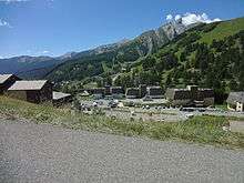
Located at the edge of the Mercantour National Park, the country of Upper Verdon and the Allos valley offers landscapes of great beauty: from the famous Lac d'Allos (Allos Lake) which is the largest mountain lake in Europe to the waterfall of La Lance, near Colmars-les-Alpes. The flora is rich and varied depending on the altitude: larch, spruce, fir as well as Alpine clematis, peonies, and Martagon.
Geology
The mountains around Allos are composed of black schist.
Relief

All around Allos from the Col d'Allos (2247 m, north of the village) and in a clockwise direction:
- on a north-south ridge of the Cheiroueche mountain (2362m) which overlooks the village, the Roche Grande (2409 m), completely denuded of vegetation;
- to the north: the Petit Cheval de Bois (Little Wooden Horse) (2754 m) and the Grand Cheval de Bois (Large Wooden Horse) (2838 m), the Pichs or Nivoulet (2575 m);
- to the east: the Cimet (3020 m), separated from the Teton (2969 m) by the small col de Talon (2678 m), Mount Pelat (3050 m), and between Allos and Mont Pelat the Tête du Vallonnet (Head of Vallonnet) (2710 m) and the Tête de Prachastel (Head of Prachastel) (2320 m);
- around Lake Allos: the Trou de l'Aigle (Hole of the Eagle) (2961 m), the Col de la Petite Cayolle (2639 m), the Garrets summit (2822 m), the Montagne de l'Avalanche (Mountain of Avalanches) (2729 m), the Tete du Lac (Head of the Lake) (2626 m), the group of Tours du Lac (Towers of the Lake) which is five peaks between 2585 and 2745 m, and the Tete de Valplane (Head of Valplane) (2624 m);
- to the South: the Roche Cline (2415 m) and on the right bank of the Verdon the Autapie (2435 m);
- to the west: the Gros Tapie (2371 m), the summit of Valcibière (2375 m), the Mourre Gros (2652 m), the Tete Noire (Black Head) (2560 m), the Tete de l'Auriac (Head of Auriac) (2639 m), the Trois-Évêchés (Three bishoprics) (2818 m), the Tete de la Sestriere (Head of Sestriere) (2575 m);
- to the northwest of the Col d'Allos: the Tete de Vescal (Head of Vescal) (2515 m).
The peaks to the west of Allos belong to the Massif des Trois-Évêchés (Three bishoprics mountains) while to the east are the secondary mountains of Mount Pelat.
Environment
The town has 1,869 hectares of woods and forests.[3]
Hamlets
- La Beaumelle;
- La Beaume;
- La Foux;
- La Foux d’Allos;
- Le Seignus (Bas and Haut);
- le Villard (Bas and Haut);
- Le Brec Bas et Haut;
- Sainte-Brigitte (Basse and Haute);
- Le Foreston;
- Bouchiers;
- La Peyrière (Basse and Haute);
- Prémin;
- Montgros;
- Champrichard;
- Le Collet;
Natural and technological risks
None of the 200 communes of the department is in a no-risk seismic area. The Canton of Allos-Colmars is in zone 1b (low risk) according to the deterministic classification of 1991 and based on historical earthquakes.[4] It is in Zone 4 (medium risk) according to the ECS probability classification of 2011.[5] Allos commune is also exposed to four other natural hazards:[5]
- avalanche
- forest fire,
- flooding (in the valley of the Verdon)
- landslide: the commune is affected by a random medium to high risk in limited areas.[6]
Allos commune is exposed to a risk of technological origin - i.e. the risk of dam breakage on the hill reservoir of Tardée above the Foux-d'Allos ski-station.[7]
The prevention plan for foreseeable natural risks (PPR) for the commune was approved in 1998 for flood risk, landslide, and avalanche;[7] and a Communal Dossier on Major Risks (DICRIM) has existed since 2010.[8]
The commune has been the location of several natural disasters: an earthquake in 1984, flooding and mudslides in 1994 and 2003.[5] In November 2012 a landslide cut off the only access road to the hamlets of Bouchiers and Le Collet - a cut that lasted more than seven months.[9]
Neighbouring communes and villages[10]
 |
Seyne | Uvernet-Fours | Enchastrayes | |
| |
Saint-Etienne-de-Tinee | |||
| ||||
| | ||||
| Beaujeu | Colmars | Entraunes |
Toponymy
The locality appears for the first time in texts from 1056 under the name of ad Alodes which means Allods in Occitan.[11][12][13] A Pre-Gallic hypothesis has also been considered[14] more in line with local phonetic rules such as Fénié. The name Allos derived then from Al- designating "rocks". The form Alodes would be in this case a bad romanization.[15] The commune is called Alòs in Occitan Vivaro-Alpine dialect.
The name of the station La Foux-d'Allos means "narrow gorges" between the surrounding peaks.[16]
History
The name of the people located in the upper valley of the Verdon is not certain but it may be the Eguiturii.[17] At the end of the Roman Empire the upper valley of the Verdon depended on the civitas and the bishopric of Thorame.[18]
It is possible that the first village was built around Notre-Dame-du-Valvert in the High Middle Ages. It would then have been perched at Banivol before moving lower in the 12th to 13th centuries.[19] The village was cited in 1056[19][20] and had its own consulat from 1233, by privilege from the Comte de Provence,[21][22] and a Fair.[23] Allos belonged to the Counts of Provence until 1388 then, with the Ubaye Valley and Nice, passed to the Counts of Savoy until 1713. From that time until the beginning of the French Revolution Allos was administratively attached to Barcelonnette. The first division of Basses-Alpes included Allos in the Barcelonnette dustrict.[24]
During the Wars of religion the Duke of Lesdiguières bombarded the town without taking it in 1597. He had brought his army through the Col de Thuiles.[25]
The peculiarities of the Allos community, which occupies several deep valleys and whose habitat is dispersed across multiple villages, led to the creation of three parishes in the 17th century: one in La Foux, one in Bouchiers, and one in Baumelle. A large number of chapels were also built: 29 in total throughout history.[19]
Several major fires ravaged the town in 1718, 1747, and 1769.[26]
During the French Revolution the commune had a patriotic society which was created at the end of 1792.[27]
In the 20th century Allos became a tourist town: in 1935, the ski-lifts were built at Seignus and Foux. In the 1970s, when winter sports become mass entertainment, more ski resorts were built in two hamlets.[25] It was not until 1985 qu'Allos turns towards the valley by integrating with the Arrondissement of Castellane.[24]
Heraldry
.svg.png) |
Blazon: Argent, a demi-vol in gules surmounting a shin-bone in sable posed in fesse.[28] |
Canting arms: Allos, in Latin Allosium, in Provençal Alouès. Alo-west Wing-bone.[28]
Administration
List of Successive Mayors[29]
| From | To | Name | Party | Position |
|---|---|---|---|---|
| 1726 | Jean-Hyacinthe Pascalis | |||
| 1748 | Hyacinthe Pellissier | |||
| 1750 | Honoré Pascalis | |||
| 1751 | Pierre-Jacques Pascalis | |||
| 1756 | Alexandre Pascalis du Laus | |||
| 1758 | Pierre Pellissier | |||
| 1780 | Joseph Guirand | |||
| 1794 | 1796 | Michel Michel | ||
| 1796 | 1798 | Pellissier | ||
| 1798 | 1799 | Joseph Caire | ||
| 1799 | 1800 | Jacques Gariel | ||
| 1800 | 1801 | Guirand | ||
| 1801 | 1802 | Alexandre Pellissier | ||
| 1802 | 1803 | Jean Honnorat | ||
| 1803 | 1806 | Hyacinthe-Marie Gariel | ||
| 1806 | 1813 | Augier | ||
| 1813 | 1830 | Rebattu | ||
| 1830 | 1840 | Jean-Jacques-Laurent Gaubert | ||
| 1840 | 1843 | Pierre Pascal | ||
| 1843 | 1846 | Hyacinthe Pellat | ||
| 1846 | 1856 | Joseph Pellissier | ||
| 1856 | 1886 | Désiré Boyer | ||
| 1886 | 1888 | Sébastien Reynaud | ||
| 1888 | Antoine Reynaud |
- Mayors from 1971
| From | To | Name | Party | Position |
|---|---|---|---|---|
| 1971 | 1996 | René Cèze[30] | RPR | |
| 1996 | 2014 | Michel Lantelme | President of the Haut-Verdon Val d'Allos Community of communes | |
| 2014 | 2020 | Chantal Caire-Caïs |
(Not all data is known)
The election of the City Council in March 2008 was the subject of an appeal to the administrative court of Marseille; the judgment led to new elections in September.
Education
The town has had a computerized library since 2004 (See online catalogue) in the Haut-Verdon library network (Communauté de communes du Haut-Verdon-Val-d'Allos) and has two primary schools (one at Allos and one in La Foux d'Allos).[31]
Demography
In 2009 the commune had 691 inhabitants. The evolution of the number of inhabitants is known through the population censuses conducted in the commune since 1793. From the 21st century, a census of communes with fewer than 10,000 inhabitants is held every five years, unlike larger towns that have a sample survey every year.[Note 1]
- Early Population
| 1315 | 1344 | 1471 | 1765 |
|---|---|---|---|
| 254 fires | 361 fires[32] | 52 fires | 1,491[25] |
sources = Édouard Baratier, Georges Duby & Ernest Hildesheimer[33]
| 1793 | 1800 | 1806 | 1821 | 1831 | 1836 | 1841 | 1846 | 1851 |
|---|---|---|---|---|---|---|---|---|
| 1,332 | 1,404 | 1,467 | 1,460 | 1,513 | 1,484 | 1,410 | 1,426 | 1,337 |
| 1856 | 1861 | 1866 | 1872 | 1876 | 1881 | 1886 | 1891 | 1896 |
|---|---|---|---|---|---|---|---|---|
| 1,332 | 1,202 | 1,205 | 1,202 | 1,121 | 1,157 | 1,127 | 972 | 932 |
| 1901 | 1906 | 1911 | 1921 | 1926 | 1931 | 1936 | 1946 | 1954 |
|---|---|---|---|---|---|---|---|---|
| 878 | 857 | 826 | 626 | 557 | 550 | 542 | 468 | 525 |
| 1962 | 1968 | 1975 | 1982 | 1990 | 1999 | 2006 | 2010 | - |
|---|---|---|---|---|---|---|---|---|
| 449 | 497 | 564 | 681 | 705 | 637 | - | 715 | - |
Sources : Ldh/EHESS/Cassini until 1962, INSEE database from 1968 (population without double counting and municipal population from 2006)

Economy

Overview
Allos is a high mountain commune whose main resource is tourism - hiking in the summer - but especially winter sports.
In 2009 the active population was 381 people including 20 unemployed[34] (46 in late 2011[35]). These workers are mostly employed (65.7%)[36] and the vast majority work in the commune (nearly 91%).[36] This can be explained by the predominance of the tourism sector which provides sufficient employment to the people of the commune. As a result, most of the people of the commune work in services and administration (97% at the end of 2010).[37] Industry, construction and agriculture no longer use a residual share of the people.[37]
At 1 January 2011 establishments active in the commune were mainly shops and services (215 of 326 establishments) and health and social administrative sector, (69).[37]
Agriculture
At the end of 2010 the primary sector (agriculture, forestry, fisheries) had 15 different establishments with 19 employees including 1 establishment employing 3 workers.[37]
Most of the survey data from the Ministry of Agriculture are subject to statistical secrecy which indicates low numbers and extent of cultivated land.[38] In 2000 three farms used a utilized agricultural area (UAA) of 281 hectares - the area has been in sharp decline since 1988 (406 hectares).[39]
Industry
In late 2010 the secondary sector (industry and construction) had 27 establishments mainly crafts (22 companies with no employees). The sector employs 11 people.[37]
Service activities
The commune has two ski-stations:
- Val d'Allos-La Foux, which links to the Pra Loup ski area;
- Val d'Allos-Le Seignus, which is called the village-station because it is connected by Aerial tramway to Allos village.

Summer tourism is also developed with different lakes and mountain walks.
In late 2010 the tertiary sector (trades and services) had 215 establishments (with 434 employees) plus 69 administrative establishments and the health and social sectors (employing 52 people).[37]
According to the Department of Tourism, tourism activity is very important for the commune with more than 5 tourists per resident[40] and with a large capacity for accommodation.[41] Several accommodation facilities for tourists exist in the commune:
- many hotels[42] (7 ranked two stars, and one three-star[43] with a capacity of 128 beds[44]);
- no camping;[45]
- some furnished,[46] some approved;[47]
- B & Bs are absent from the commune;[48]
- a large carrying capacity in various collective accommodations (summer shelters, youth hostels, holiday villages).[49]
It is nevertheless second homes that weigh more heavily on the capacity with almost 5,000 second homes (4,900 out of 5,340 dwellings[43][50]).
Culture and heritage
The commune contains a very large number of sites that are registered as historical monuments. For a complete list with links to descriptions (in French) and photos click here. Lists below are abridged showing the main sites.
There is also a very large number of items registered as historical objects located at:
- The Chapel of Notre-Dame-de-la-Fleur (2 items)
- The Chapel of Notre-Dame-de-la-Salette (1 item)
- The Chapel of Saint-Antoine (11 items)
- The Chapel of Saint-Laurent (8 items)
- The Chapel of Saint Pierre (6 items)
- The Chapel of Saint Sebastian (58 items)
- The Chapel of Sainte-Marie-Madeleine (5 items)
- The Church of Notre-Dame-de-Valvert (59 items)
- The Church of Notre-Dame-de-la-Baumelle (3 items)
- The Chapel of Notre-Dame-de-Lumiere (12 items)
- The Church of Saint John the Baptist (21 items)
For a complete list of all historical objects with links to descriptions (in French) and photos click here.
Civil heritage
There are still remnants of medieval structures:
- The City Fortifications (Middle Ages)
 [51]
[51] - The Banivol Tower (Middle Ages)[52] is 7.2 m square. It may have protected a small town.[19]
Examples of later structures registered as historical monuments:
- The Cooperative Dairy Factory (1931)[53]
- The Abrau Bridge (16th century)[25]
- A Lavoir (Public laundry) (19th century)[54]
- The Town Hall (19th century)[55]
- Other sites of interest
- The Ski-station of Foux d'Allos in the classic style of ski-stations with roofs dominated by corrugated iron (mid-1980s)[56] with a presence of roof slate and traditional scale tiles.
- A Sundial in Allos village (1913).[57]
Religious monuments
The churches and rural chapels are in a simple alpine style imposed by the climate. Notre-Dame-de-Valvert at Allos is a good example from the 13th century.
The extent of the commune with its large population the 19th century, when the parishes and their branches were under the Concordat plan, made communications difficult due to the terrain and snow in winter. All these conditions justified the creation of several parish churches which are now registered as historical monuments:
- The Church of Notre-Dame-de-Valvert (13th century) [58][59]
- The Parish Church of Saint John the Baptist at la Foux (17th century)[60] in traditional Romanesque style[61] and whose facade is decorated with a sundial from 1757.[62] It has an ex-voto in leather from Cordoba dated 1675;[63]
- The Parish Church of Saint-Antoine at Bouchier (1862)[64]
The commune also has many chapels which are also registered as historical monuments:
- The Chapel of Saint Sebastian or Chapel of White Penitents (18th century)[65][66] has the rise to glory of Saint Sebastian painted on the dome.[67] It is used for parish worship in Winter.[19]
- The Chapel of Notre-Dame-de-la-Fleur at Villard-Haut (17th century)[19][68]
- The Chapel of Sainte-Marie-Madeleine at Villard-Bas (19th century)[19][69]
- The Chapel of Notre-Dame-de-Grâce at Seignus-Bas (19th century).[19][70]
- The Chapel of Sainte-Brigitte and Saint-Joseph at Sainte-Brigitte (1890)[19][71]
- The Chapel of Saint-Roch at Plan-Ouest (17th century)[19][72]
- The Chapel of Saint Laurent at Seignus-Haut (1624)[19][73]
- The Chapel of Notre-Dame-de-Lumière (formerly a parish church) at Baumelle (1857)[74]
- The Chapel of Saint-Pierre near Basse-Colette (16th century)[75] has a Retable closed by two small doors from the 16th century[76]
- The Chapel of Notre-Dame-de-la-Salette at Charrières-Sud (19th century)[77]
- Other religious sites of interest
- The Chapel of Notre-Dame-des-Monts has a sundial dated 1757 and bearing the legend Dieu seul est éternel; déjà loin de toi ("God alone is eternal; already far from you")[78]
- The Chapel of Saint-Jacques at Seignus-Bas[19]

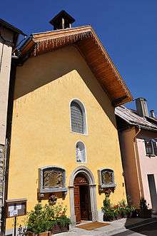
The Church of Notre-Dame-de-Valvert

The parish church of Allos dates from the first half of the 13th century[19] and was listed as a historical monument in 1846 for the parts dating from the second half of the 9th and 10th centuries.[58]
It is built in Brickwork in a regular way with a chevet made of a single semicircular Apse, vaulted in cul-de-four.[79] Like all churches in alpine style only the south wall has three bays which are semicircular.
The decor is unusual with walls decorated with a series of small arcs. The decor is a late development (13th century) of the Lombard band.[80] The capitals are adorned with foliage, except for the facade, and decorated with masks (Lombard influence) and animals.[81] The front is reinforced by two buttresses at the corners.
Raymond Collier identifies several characteristics of Notre-Dame-de-Valvert different from the communal type of alpine Romanesque:
- the pilasters supporting the Arc-doubleaux are replaced by engaged columns (or half-columns);[82]
It was damaged at the beginning of the 17th century and again in 1697 by the war: the second time the Savoyards caused the collapse of the tower. The vault of the choir was repaired between that date and 1723 before the bell was worn out in 1727. The Allos fire on 15 November 1747 reached the church and caused extensive damage. A new tower was built in 1751. Major restoration work took place between 1894 and 1896: the bottom of the facade and the Mur gouttereau (guttered walls), the bay windows, and the Buttresses were completely rebuilt and the roof of the third bay itself was also completely rebuilt. The rest of the arches and the bell tower were rebuilt in 1899-1904 with various repairs, when the murals disappeared.
Picture Gallery
-

Chapel
-

Allos lake
-

Allos lake and Mt. Pelat
-

Allos lake and the chaple
Notable people linked to the commune
- Patritti: a painter of the 19th century
- Jean-Esprit Pellissier, priest until 1905, he was the historian of the town.
- Simon-Jude Honnorat (1783-1852), doctor and also the town historian and author of the Great dictionary of the Occitan language
See also
Bibliography
- Raymond Collier, Haute-Provence monumental and artistic, Digne, Imprimerie Louis Jean, 1986, 559 p. (French)
- Edited by Édouard Baratier, Georges Duby, and Ernest Hildesheimer, Historical Atlas. Provence, Comtat Venaissin, Principality of Orange, County of Nice, Principality of Monaco, Librairie Armand Colin, Paris, 1969 (French)
External links
- Allos on the old National Geographic Institute website (French)
- History of Allos (French)
- Allos on Lion1906
- Allos on Google Maps
- Allos on Géoportail, National Geographic Institute (IGN) website (French)
- Allos on the 1750 Cassini Map
- Allos on the INSEE website (French)
- INSEE (French)
Notes and references
Notes
- ↑ At the beginning of the 21st century, the methods of identification have been modified by law No. 2002-276 of 27 February 2002 , the so-called "law of local democracy" and in particular Title V "census operations" which allow, after a transitional period running from 2004 to 2008, the annual publication of the legal population of the different French administrative districts. For communes with a population greater than 10,000 inhabitants, a sample survey is conducted annually, the entire territory of these communes is taken into account at the end of the period of five years. The first "legal population" after 1999 under this new law came into force on 1 January 2009 and was based on the census of 2006.
References
- ↑ Inhabitants of Alpes-de-Haute-Provence (French)
- ↑ Michel de La Torre, Alpes-de-Haute-Provence: the complete guide to 200 communes, Paris, Deslogis-Lacoste, coll. Towns and villages of France, 1989, Relié, 72 p. (non-paginated) (ISBN 2-7399-5004-7)
- ↑ Roger Brunet, Canton of Allos, Le Trésor des régions, consulted on 9 June 2013
- ↑ Préfecture of Alpes-de-Haute-Provence, Departmental dossier on major risks in Alpes-de-Haute-Provence (DDRM), 2008, p. 39 (French)
- 1 2 3 Ministry of Ecology, sustainable development, transport, and housing, Communal Notice on the Gaspar database, dated 27 May 2011, consulted on 25 June 2012 (French)
- ↑ Préfecture, DDRM, p. 37
- 1 2 Préfecture des Alpes-de-Haute-Provence, Departmental dossier on major risks in Alpes-de-Haute-Provence, p. 95 (French)
- ↑ Dicrim of Allos, Dicrim database, consulted on 25 June 2011
- ↑ R. F. and F. R., The two isolated hamlets after a landslide, La Provence, 21 June 2013, p. 14 (French)
- ↑ Google Maps
- ↑ Ernest Nègre, General Toponymy of France: etymology of 35,000 placenames, Genève: Librairie Droz, 1990. Collection Publications romanes et françaises, volume 193. Volume III: Formations dialectales (suite); formations françaises. Notice 26931. (French)
- ↑ Charles Rostaing, Essay on the Toponymy of Provence: since its origin to the barbarian invasions, Laffite Reprints, Marseille, 1973 (1st edition 1950), p 44-45 (French)
- ↑ Historical Atlas of Provence, p. 159-160
- ↑ Charles Rostaing, Toponymy of pre-gauloise origins in Baratier, Duby & Hildesheimer, Map 11 and commentary (French)
- ↑ Bénédicte Fénié, Jean-Jacques Fénié, Provençale Toponymy, Éditions Sud-Ouest, 2002 (reprint), ISBN 978-2-87901-442-5, p. 17-18 (French)
- ↑ Bénédicte Fénié, Jean-Jacques Fénié, Provençale Toponymy, Éditions Sud-Ouest, 2002 (reprint), ISBN 978-2-87901-442-5, p. 88
- ↑ Raymond Boyer and Guy Barruol, Map 12 People and habitats of the pre-roman era, in Baratier, Duby & Hildesheimer, Historical Atlas of Provence, and commentary (French)
- ↑ Brigitte Beaujard, The cities of southern Gaul from the 3rd to the 7th centuries, Gallia, 63, 2006, CNRS éditions, p. 22 (French)
- 1 2 3 4 5 6 7 8 9 10 11 12 13 Daniel Thiery, Allos, On the origins of churches and rural chapels of Alpes-de-Haute-Provence, published on 12 December 2010, online on 15 December 2010, consulted on 25 June 2012 (French)
- ↑ Ministry of Culture, Mérimée IA04000235 Presentation of the Commune (French)
- ↑ Mireille Mistral, The Drapery industry in the Valley of Verdon, Doctoral thesis for the State in Economic Science, Académie d’Aix-en-Provence, Nice, 1951, 231 p. p 43 (French)
- ↑ André Gouron, Diffusion of Southern consulates and expansion of Roman law in the 12th and 13th centuries, Bibliothèque de l'école des chartes, 1963, Vol. 121. p. 49.
- ↑ Louis Stouff, Map 86: Port, routes and fairs of the 13th to the 15th centuries, in the Historical Atlas of Provence (French)
- 1 2 EHESS, Communal Notice for Allos on the Cassini website, consulted on 18 July 2009
- 1 2 3 4 Ministry of Culture, Mérimée IA04000293 Abrau Bridge (French)

- ↑ Mireille Mistral, p 44
- ↑ Patrice Alphand, "The Popular Societies", The Revolution in the Basses-Alpes, Annales de Haute-Provence, bulletin de la société scientifique et littéraire des Alpes-de-Haute-Provence, no 307, 1st trimester 1989, 108th year, p 296-298 (French)
- 1 2 Louis de Bresc Arms of the communes of Provence, 1866. Reprint - Marcel Petit CPM - Raphèle-lès-Arles 1994 (French)
- ↑ List of Mayors of France
- ↑ René Cèze is one of the 500 elected deputies who supported the candidature of Jacques Chirac (RPR) at the French presidential election, 1995, cf Constitutional Council, List of citizens who presented candidates for the election of President of the Republic, Official Journal of the French Republic of 12 April 1995, page 5736, available online, consulted on 29 July 2010
- ↑ Academic Inspection directorate of Alpes-de-Haute-Provence, List of schools in the electoral district of Digne, published on 6 April 2010, consulted on 31 October 2010
- ↑ Mireille Mistral, p. 47 (French)
- ↑ Historical Atlas of Provence, p. 159 (French)
- ↑ Insee, Dossier local - Commune:, p. 5
- ↑ Insee, Local Dossier, p. 8 (French)
- 1 2 Insee, Local Dossier, p. 7 (French)
- 1 2 3 4 5 6 Insee, LOcal Dossier, p. 16 (French)
- ↑ Ministry of Agriculture, "Technical-Economic Orientation of exploitation", Agricultural census 2010 and 2000. (Place: N.B. Page 4.4 Mio) (French)
- ↑ Insee, Agricultural businesses in 1988 and 2000, Insee, 2012 (Page 24.6 Mio) (French)
- ↑ Departemental Observatory of tourism, Atlas of Tourist Accommodation, December 2008, p. 6 (French)
- ↑ Atlas of Tourist Accommodation, p. 7
- ↑ Atlas of Tourist Accommodation, p. 11
- 1 2 Insee, Communal Tourist Accommodations, 2008, 2009 and 2012, INSEE, 2012 (Page 20.8 Mio)
- ↑ Atlas of Tourist Accommodation, p. 17
- ↑ Atlas of Tourist Accommodation, p. 21
- ↑ Atlas of Tourist Accommodation, p. 32
- ↑ Atlas of Tourist Accommodation, p. 33
- ↑ Atlas of Tourist Accommodation, p. 38
- ↑ Atlas of Tourist Accommodation, p. 30
- ↑ Insee, Departmental data, consulted on 18 February 2013
- ↑ Ministry of Culture, Mérimée IA04000291 City Fortifications (French)
- ↑ Ministry of Culture, Mérimée IA04000349 Banivol Tower (French)
- ↑ Ministry of Culture, Mérimée IA04000055 Cooperative Dairy Factory (French)
- ↑ Ministry of Culture, Mérimée IA04000206 Lavoir (French)
- ↑ Ministry of Culture, Mérimée IA04000159 Town Hall (French)
- ↑ Raymond Collier, Haute-Provence monumental and artistic, Digne, Imprimerie Louis Jean, 1986, 559 p., p 345 from the middle of the 1980s (French)
- ↑ Jean-Marie Homet and Franck Rozet, Sundials of Alpes-de-Haute-Provence, Édisud, Aix-en-Provence, 2002, ISBN 2-7449-0309-4, p 77 (French)
- 1 2 Ministry of Culture, Mérimée IA04000164 Church of Notre-Dame-de-Valvert (French)
- ↑ Ministry of Culture, Mérimée PA00080349 Church of Notre-Dame-de-Valvert (French)
- ↑ Ministry of Culture, Mérimée IA04000165 Parish Church of Saint John the Baptist (French)
- ↑ Raymond Collier, Haute-Provence monumental and artistic, Digne, Imprimerie Louis Jean, 1986, 559 p., p 216 (French)
- ↑ Raymond Collier, Haute-Provence monumental and artistic, Digne, Imprimerie Louis Jean, 1986, 559 p., p 448 (French)
- ↑ Raymond Collier, Haute-Provence monumental and artistic, Digne, Imprimerie Louis Jean, 1986, 559 p., p 532 (French)
- ↑ Ministry of Culture, Mérimée IA04000166 Parish Church of Saint-Antoine (French)
- ↑ Ministry of Culture, Mérimée PA04000001 Chapel of Saint Sebastian (French)
- ↑ Ministry of Culture, Mérimée IA04000120 Chapel of White Penitents (French)
- ↑ Raymond Collier, Haute-Provence monumental and artistic, Digne, Imprimerie Louis Jean, 1986, 559 p., p 487 (French)
- ↑ Ministry of Culture, Mérimée IA04000265 Chapel of Notre-Dame-de-la-Fleur (French)
- ↑ Ministry of Culture, Mérimée IA04000220 Chapel of Sainte-Marie-Madeleine at Villard-Bas (French)
- ↑ Ministry of Culture, Mérimée IA04000216 Chapel of Notre-Dame-de-Grâce at Seignus-Bas (French)
- ↑ Ministry of Culture, Mérimée IA04000215 Chapel of Sainte-Brigitte and Saint-Joseph at Sainte-Brigitte (French)
- ↑ Ministry of Culture, Mérimée IA04000213 Chapel of Saint-Roch at Plan-Ouest (French)
- ↑ Ministry of Culture, Mérimée IA04000212 Chapel of Saint Laurent at Seignus-Haut (French)
- ↑ Ministry of Culture, Mérimée IA04000210 Chapel of Notre-Dame-de-Lumière at Baumelle (French)
- ↑ Ministry of Culture, Mérimée IA04000161 Chapel of Saint-Pierre near Basse-Colette (French)
- ↑ Raymond Collier, Haute-Provence monumental and artistic, Digne, Imprimerie Louis Jean, 1986, 559 p., p 471 (French)
- ↑ Ministry of Culture, Mérimée IA04000160 Chapel of Notre-Dame-de-la-Salette at Charrières-Sud (French)
- ↑ Jean-Marie Homet and Franck Rozet, Sundials of Alpes-de-Haute-Provence, Édisud, Aix-en-Provence, 2002, ISBN 2-7449-0309-4, p 86 (French)
- ↑ Raymond Collier, Haute-Provence monumental and artistic, Digne, Imprimerie Louis Jean, 1986, 559 p., p 114 (French)
- ↑ Raymond Collier, Haute-Provence monumental and artistic, Digne, Imprimerie Louis Jean, 1986, 559 p., p 80 (French)
- ↑ Raymond Collier, Haute-Provence monumental and artistic, Digne, Imprimerie Louis Jean, 1986, 559 p., p 115 (French)
- ↑ Raymond Collier, Haute-Provence monumental and artistic, Digne, Imprimerie Louis Jean, 1986, 559 p., p 75 (French)
| Wikimedia Commons has media related to Allos. |