Brunet, Alpes-de-Haute-Provence
| Brunet | ||
|---|---|---|
|
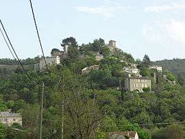
The village of Brunet, seen from the north | ||
| ||
 Brunet | ||
|
Location within Provence-A.-C.d'A. region  Brunet | ||
| Coordinates: 43°53′32″N 6°01′52″E / 43.8922°N 6.0311°ECoordinates: 43°53′32″N 6°01′52″E / 43.8922°N 6.0311°E | ||
| Country | France | |
| Region | Provence-Alpes-Côte d'Azur | |
| Department | Alpes-de-Haute-Provence | |
| Arrondissement | Digne-les-Bains | |
| Canton | Valensole | |
| Government | ||
| • Mayor (2008–2014) | Francis Berard | |
| Area1 | 28.47 km2 (10.99 sq mi) | |
| Population (2008)2 | 258 | |
| • Density | 9.1/km2 (23/sq mi) | |
| Time zone | CET (UTC+1) | |
| • Summer (DST) | CEST (UTC+2) | |
| INSEE/Postal code | 04035 / 04210 | |
| Elevation |
369–690 m (1,211–2,264 ft) (avg. 425 m or 1,394 ft) | |
|
1 French Land Register data, which excludes lakes, ponds, glaciers > 1 km² (0.386 sq mi or 247 acres) and river estuaries. 2 Population without double counting: residents of multiple communes (e.g., students and military personnel) only counted once. | ||

Brunet is a commune in the Alpes-de-Haute-Provence department in southeastern France.
Geography
The village lies on the left bank of the Asse, which forms most of the commune's northern border.
Population
| Historical population | ||
|---|---|---|
| Year | Pop. | ±% |
| 1765 | 418 | — |
| 1793 | 415 | −0.7% |
| 1806 | 483 | +16.4% |
| 1821 | 521 | +7.9% |
| 1831 | 509 | −2.3% |
| 1836 | 520 | +2.2% |
| 1841 | 487 | −6.3% |
| 1846 | 427 | −12.3% |
| 1851 | 456 | +6.8% |
| 1856 | 463 | +1.5% |
| 1861 | 430 | −7.1% |
| 1866 | 433 | +0.7% |
| 1872 | 418 | −3.5% |
| 1876 | 414 | −1.0% |
| 1881 | 390 | −5.8% |
| 1886 | 368 | −5.6% |
| 1891 | 346 | −6.0% |
| 1896 | 330 | −4.6% |
| 1901 | 342 | +3.6% |
| 1906 | 356 | +4.1% |
| 1911 | 321 | −9.8% |
| 1921 | 290 | −9.7% |
| 1926 | 234 | −19.3% |
| 1931 | 228 | −2.6% |
| 1936 | 200 | −12.3% |
| 1946 | 182 | −9.0% |
| 1954 | 187 | +2.7% |
| 1962 | 190 | +1.6% |
| 1968 | 186 | −2.1% |
| 1975 | 217 | +16.7% |
| 1982 | 258 | +18.9% |
| 1990 | 162 | −37.2% |
| 1999 | 218 | +34.6% |
| 2008 | 258 | +18.3% |
See also
References
| Wikimedia Commons has media related to Brunet, Alpes-de-Haute-Provence. |
This article is issued from Wikipedia - version of the 3/15/2016. The text is available under the Creative Commons Attribution/Share Alike but additional terms may apply for the media files.