Entrages
| Entrages | ||
|---|---|---|
|
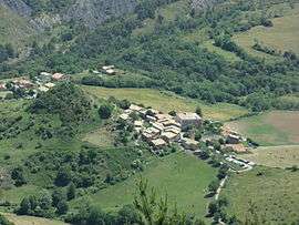
The village of Entrages, seen from the Cousson | ||
| ||
 Entrages | ||
|
Location within Provence-A.-C.d'A. region  Entrages | ||
| Coordinates: 44°02′49″N 6°16′01″E / 44.0469°N 6.2669°ECoordinates: 44°02′49″N 6°16′01″E / 44.0469°N 6.2669°E | ||
| Country | France | |
| Region | Provence-Alpes-Côte d'Azur | |
| Department | Alpes-de-Haute-Provence | |
| Arrondissement | Digne-les-Bains | |
| Canton | Digne-les-Bains-Est | |
| Intercommunality | Trois Vallées | |
| Government | ||
| • Mayor (2008–2014) | Marie-José Magaud | |
| Area1 | 22.61 km2 (8.73 sq mi) | |
| Population (2008)2 | 114 | |
| • Density | 5.0/km2 (13/sq mi) | |
| Time zone | CET (UTC+1) | |
| • Summer (DST) | CEST (UTC+2) | |
| INSEE/Postal code | 04074 / 04000 | |
| Elevation |
593–1,515 m (1,946–4,970 ft) (avg. 923 m or 3,028 ft) | |
|
1 French Land Register data, which excludes lakes, ponds, glaciers > 1 km² (0.386 sq mi or 247 acres) and river estuaries. 2 Population without double counting: residents of multiple communes (e.g., students and military personnel) only counted once. | ||

Entrages is a commune in the Alpes-de-Haute-Provence department in southeastern France.
Geography
The river Asse forms most of the commune's southern border.
Population
| Historical population | ||
|---|---|---|
| Year | Pop. | ±% |
| 1765 | 321 | — |
| 1793 | 330 | +2.8% |
| 1800 | 300 | −9.1% |
| 1806 | 310 | +3.3% |
| 1821 | 277 | −10.6% |
| 1831 | 298 | +7.6% |
| 1836 | 296 | −0.7% |
| 1841 | 317 | +7.1% |
| 1846 | 298 | −6.0% |
| 1851 | 306 | +2.7% |
| 1856 | 274 | −10.5% |
| 1861 | 270 | −1.5% |
| 1866 | 269 | −0.4% |
| 1872 | 256 | −4.8% |
| 1876 | 255 | −0.4% |
| 1881 | 259 | +1.6% |
| 1886 | 212 | −18.1% |
| 1891 | 480 | +126.4% |
| 1896 | 201 | −58.1% |
| 1901 | 198 | −1.5% |
| 1906 | 166 | −16.2% |
| 1911 | 165 | −0.6% |
| 1921 | 104 | −37.0% |
| 1926 | 98 | −5.8% |
| 1931 | 101 | +3.1% |
| 1936 | 82 | −18.8% |
| 1946 | 89 | +8.5% |
| 1954 | 90 | +1.1% |
| 1962 | 71 | −21.1% |
| 1968 | 75 | +5.6% |
| 1975 | 68 | −9.3% |
| 1982 | 65 | −4.4% |
| 1990 | 92 | +41.5% |
| 1999 | 85 | −7.6% |
| 2008 | 114 | +34.1% |
See also
References
| Wikimedia Commons has media related to Entrages. |
This article is issued from Wikipedia - version of the 2/3/2015. The text is available under the Creative Commons Attribution/Share Alike but additional terms may apply for the media files.