Clamensane
| Clamensane | ||
|---|---|---|
|
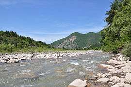
The Sasse | ||
| ||
 Clamensane | ||
|
Location within Provence-A.-C.d'A. region  Clamensane | ||
| Coordinates: 44°19′23″N 6°04′08″E / 44.3231°N 6.0689°ECoordinates: 44°19′23″N 6°04′08″E / 44.3231°N 6.0689°E | ||
| Country | France | |
| Region | Provence-Alpes-Côte d'Azur | |
| Department | Alpes-de-Haute-Provence | |
| Arrondissement | Forcalquier | |
| Canton | La Motte-du-Caire | |
| Government | ||
| • Mayor (2008–2014) | Elsa Raymond | |
| Area1 | 23.73 km2 (9.16 sq mi) | |
| Population (2008)2 | 160 | |
| • Density | 6.7/km2 (17/sq mi) | |
| Time zone | CET (UTC+1) | |
| • Summer (DST) | CEST (UTC+2) | |
| INSEE/Postal code | 04057 / 04250 | |
| Elevation |
630–1,658 m (2,067–5,440 ft) (avg. 700 m or 2,300 ft) | |
|
1 French Land Register data, which excludes lakes, ponds, glaciers > 1 km² (0.386 sq mi or 247 acres) and river estuaries. 2 Population without double counting: residents of multiple communes (e.g., students and military personnel) only counted once. | ||

Clamensane is a commune in the Alpes-de-Haute-Provence department in southeastern France.
Geography
The village is located 700 m above sea level, at the confluence of Sasse and Vermeil rivers.[1]
Population
| Historical population | ||
|---|---|---|
| Year | Pop. | ±% |
| 1765 | 428 | — |
| 1793 | 424 | −0.9% |
| 1800 | 466 | +9.9% |
| 1806 | 260 | −44.2% |
| 1821 | 486 | +86.9% |
| 1831 | 375 | −22.8% |
| 1836 | 442 | +17.9% |
| 1841 | 429 | −2.9% |
| 1846 | 426 | −0.7% |
| 1851 | 404 | −5.2% |
| 1856 | 382 | −5.4% |
| 1861 | 369 | −3.4% |
| 1866 | 369 | +0.0% |
| 1872 | 347 | −6.0% |
| 1876 | 340 | −2.0% |
| 1881 | 353 | +3.8% |
| 1886 | 304 | −13.9% |
| 1891 | 287 | −5.6% |
| 1896 | 255 | −11.1% |
| 1901 | 276 | +8.2% |
| 1906 | 249 | −9.8% |
| 1911 | 256 | +2.8% |
| 1921 | 220 | −14.1% |
| 1926 | 175 | −20.5% |
| 1931 | 174 | −0.6% |
| 1936 | 161 | −7.5% |
| 1946 | 153 | −5.0% |
| 1954 | 133 | −13.1% |
| 1962 | 128 | −3.8% |
| 1968 | 125 | −2.3% |
| 1975 | 106 | −15.2% |
| 1982 | 110 | +3.8% |
| 1990 | 115 | +4.5% |
| 1999 | 131 | +13.9% |
| 2008 | 160 | +22.1% |
See also
References
- ↑ de La Torre, 1989, p.72
- Michel de La Torre, Alpes-de-Haute-Provence : le guide complet des 200 communes, Paris, Deslogis-Lacoste, coll. « Villes et villages de France », 1989, Relié, 72 p. (non-paginé) (ISBN 2-7399-5004-7)
| Wikimedia Commons has media related to Clamensane. |
This article is issued from Wikipedia - version of the 2/21/2013. The text is available under the Creative Commons Attribution/Share Alike but additional terms may apply for the media files.