Majastres
| Majastres | ||
|---|---|---|
|
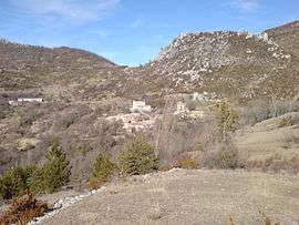
A general view of the village of Majastres | ||
| ||
 Majastres | ||
|
Location within Provence-A.-C.d'A. region  Majastres | ||
| Coordinates: 43°54′51″N 6°17′23″E / 43.9142°N 6.2897°ECoordinates: 43°54′51″N 6°17′23″E / 43.9142°N 6.2897°E | ||
| Country | France | |
| Region | Provence-Alpes-Côte d'Azur | |
| Department | Alpes-de-Haute-Provence | |
| Arrondissement | Digne-les-Bains | |
| Canton | Mézel | |
| Intercommunality | Asse | |
| Government | ||
| • Mayor (2008–2014) | Gustave Pierrisnard | |
| Area1 | 29.85 km2 (11.53 sq mi) | |
| Population (2008)2 | 2 | |
| • Density | 0.067/km2 (0.17/sq mi) | |
| Time zone | CET (UTC+1) | |
| • Summer (DST) | CEST (UTC+2) | |
| INSEE/Postal code | 04107 / 04270 | |
| Elevation |
800–1,860 m (2,620–6,100 ft) (avg. 1,143 m or 3,750 ft) | |
|
1 French Land Register data, which excludes lakes, ponds, glaciers > 1 km² (0.386 sq mi or 247 acres) and river estuaries. 2 Population without double counting: residents of multiple communes (e.g., students and military personnel) only counted once. | ||

Majastres is a commune in the Alpes-de-Haute-Provence department in southeastern France.
Population
| Historical population | ||
|---|---|---|
| Year | Pop. | ±% |
| 1765 | 276 | — |
| 1793 | 224 | −18.8% |
| 1800 | 202 | −9.8% |
| 1806 | 216 | +6.9% |
| 1821 | 248 | +14.8% |
| 1831 | 270 | +8.9% |
| 1836 | 270 | +0.0% |
| 1841 | 263 | −2.6% |
| 1846 | 259 | −1.5% |
| 1851 | 225 | −13.1% |
| 1856 | 245 | +8.9% |
| 1861 | 226 | −7.8% |
| 1866 | 213 | −5.8% |
| 1872 | 202 | −5.2% |
| 1876 | 165 | −18.3% |
| 1881 | 166 | +0.6% |
| 1886 | 174 | +4.8% |
| 1891 | 156 | −10.3% |
| 1896 | 143 | −8.3% |
| 1901 | 137 | −4.2% |
| 1906 | 117 | −14.6% |
| 1911 | 95 | −18.8% |
| 1921 | 57 | −40.0% |
| 1926 | 54 | −5.3% |
| 1931 | 41 | −24.1% |
| 1936 | 44 | +7.3% |
| 1946 | 43 | −2.3% |
| 1954 | 35 | −18.6% |
| 1962 | 27 | −22.9% |
| 1968 | 20 | −25.9% |
| 1975 | 14 | −30.0% |
| 1982 | 12 | −14.3% |
| 1990 | 10 | −16.7% |
| 1999 | 8 | −20.0% |
| 2008 | 2 | −75.0% |
See also
References
| Wikimedia Commons has media related to Majastres. |
This article is issued from Wikipedia - version of the 3/15/2016. The text is available under the Creative Commons Attribution/Share Alike but additional terms may apply for the media files.