Chaudon-Norante
| Chaudon-Norante | ||
|---|---|---|
|
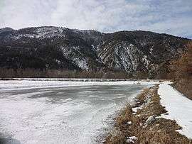
The Lac de Norante | ||
| ||
 Chaudon-Norante | ||
|
Location within Provence-A.-C.d'A. region  Chaudon-Norante | ||
| Coordinates: 43°58′49″N 6°18′46″E / 43.9803°N 6.3128°ECoordinates: 43°58′49″N 6°18′46″E / 43.9803°N 6.3128°E | ||
| Country | France | |
| Region | Provence-Alpes-Côte d'Azur | |
| Department | Alpes-de-Haute-Provence | |
| Arrondissement | Digne-les-Bains | |
| Canton | Barrême | |
| Intercommunality | Moyen Verdon | |
| Government | ||
| • Mayor (2008–2014) | Marcel Imbert | |
| Area1 | 37.48 km2 (14.47 sq mi) | |
| Population (2008)2 | 144 | |
| • Density | 3.8/km2 (10.0/sq mi) | |
| Time zone | CET (UTC+1) | |
| • Summer (DST) | CEST (UTC+2) | |
| INSEE/Postal code | 04055 / 04430 | |
| Elevation |
628–1,612 m (2,060–5,289 ft) (avg. 666 m or 2,185 ft) | |
|
1 French Land Register data, which excludes lakes, ponds, glaciers > 1 km² (0.386 sq mi or 247 acres) and river estuaries. 2 Population without double counting: residents of multiple communes (e.g., students and military personnel) only counted once. | ||

Chaudon-Norante is a commune in the Alpes-de-Haute-Provence department in southeastern France.
Geography
The river Asse flows northwest through the commune.
Population
| Historical population | ||
|---|---|---|
| Year | Pop. | ±% |
| 1793 | 477 | — |
| 1800 | 523 | +9.6% |
| 1806 | 542 | +3.6% |
| 1821 | 564 | +4.1% |
| 1831 | 600 | +6.4% |
| 1836 | 671 | +11.8% |
| 1841 | 651 | −3.0% |
| 1846 | 612 | −6.0% |
| 1851 | 558 | −8.8% |
| 1856 | 505 | −9.5% |
| 1861 | 504 | −0.2% |
| 1866 | 463 | −8.1% |
| 1872 | 428 | −7.6% |
| 1876 | 410 | −4.2% |
| 1881 | 383 | −6.6% |
| 1886 | 403 | +5.2% |
| 1891 | 724 | +79.7% |
| 1896 | 356 | −50.8% |
| 1901 | 321 | −9.8% |
| 1906 | 320 | −0.3% |
| 1911 | 296 | −7.5% |
| 1921 | 231 | −22.0% |
| 1926 | 194 | −16.0% |
| 1931 | 154 | −20.6% |
| 1936 | 163 | +5.8% |
| 1946 | 135 | −17.2% |
| 1954 | 109 | −19.3% |
| 1962 | 105 | −3.7% |
| 1968 | 90 | −14.3% |
| 1975 | 72 | −20.0% |
| 1982 | 76 | +5.6% |
| 1990 | 101 | +32.9% |
| 1999 | 129 | +27.7% |
| 2008 | 144 | +11.6% |
See also
References
| Wikimedia Commons has media related to Chaudon-Norante. |
This article is issued from Wikipedia - version of the 2/3/2015. The text is available under the Creative Commons Attribution/Share Alike but additional terms may apply for the media files.