Angles, Alpes-de-Haute-Provence
| Angles | ||
|---|---|---|
|
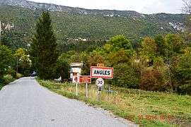
The road into Angles | ||
| ||
 Angles | ||
|
Location within Provence-A.-C.d'A. region  Angles | ||
| Coordinates: 43°56′37″N 6°33′32″E / 43.9436°N 6.5589°ECoordinates: 43°56′37″N 6°33′32″E / 43.9436°N 6.5589°E | ||
| Country | France | |
| Region | Provence-Alpes-Côte d'Azur | |
| Department | Alpes-de-Haute-Provence | |
| Arrondissement | Castellane | |
| Canton | Saint-André-les-Alpes | |
| Intercommunality | Moyen Verdon | |
| Government | ||
| • Mayor (2008–2020) | Aimé Bac | |
| Area1 | 9.83 km2 (3.80 sq mi) | |
| Population (2009)2 | 74 | |
| • Density | 7.5/km2 (19/sq mi) | |
| Time zone | CET (UTC+1) | |
| • Summer (DST) | CEST (UTC+2) | |
| INSEE/Postal code | 04007 / 04170 | |
| Elevation |
880–1,777 m (2,887–5,830 ft) (avg. 956 m or 3,136 ft) | |
|
1 French Land Register data, which excludes lakes, ponds, glaciers > 1 km² (0.386 sq mi or 247 acres) and river estuaries. 2 Population without double counting: residents of multiple communes (e.g., students and military personnel) only counted once. | ||
Angles is a French commune in the Alpes-de-Haute-Provence department in the Provence-Alpes-Côte d'Azur region of southeastern France.
Geography
Angles is located some 5 km south-east of Saint-Andre-les-Alpes and 15 km north-east of Castellane. The village is close to the centre of the commune in the valley of the Torrent d'Angles at an altitude of 956m.[1] National Highway N202 passes along the south-west edge of the commune in a tunnel with a country road branching north-east to the village then continuing south-east to Vergons. The commune is remote and rugged with extensive forests totalling 417 hectares which is almost half the total area.[2] There is a small area of farming activity near the village.[3]
The highest points in the commune are at Baisse d'Angles (1577m) and Serre Gros (1778m) on the Crest of Serres.
The Torrent d'Angles flows through the commune from the south-east and curves to the south-west where it joins the Verdon which is at the south-western border of the commune. Many tributaries flow into the Torrent d'Angles from the north including the Ravin des Bastides, Ravin de Pas d'Empicon, and numerous other unnamed streams.[3]
Neighbouring communes and villages[3]
 |
Saint-Andre-les-Alpes | Le Fugeret | | |
| Barreme | |
Annot | ||
| ||||
| | ||||
| Senez | Saint-Julien-du-Verdon | Vergons |
Toponymy
The locality was reported for the first time in texts from the 13th century (Angulis). The name refers to an element of the landscape shaped like a wedge: the village according to Ernest Nègre,[4] or the fields according to Fénié.[5]
The name of the district of Moustier is from the traces of the priory of Lérins in that name.[6]
History
Augustus conquered the valley of the Verdon at the same time as the Alps which he completed in 14 BC. It is difficult to know the name of the Gallic people who inhabited the valley nor who were the Civitas on whom the Angles valley depended in the High Empire: Eturamina (Thorame), Civitas Saliniensum (Castellane), or Sanitensium (Senez). At the end of the Roman Empire, its connection to that of Sanitensium and its diocese seems proven.[7]
The locality appears for the first time in charters from 1245[1][8] as it was a co-lordship of the bishops of Senez and the Abbey of Lérins. Its priory was joined to Vergons in 1454.[9] The Abbot of Lérins built a hospice which then passed to Agoult.[10]
The community was under the Viguerie of Castellane.[6]
The inhabitants of Angles lead a struggle against the local lord over several generations and denied the rights of the half-lords to any inheritance. After the non-payments and a trial, the Lord's pew in the church was smashed to pieces. In 1731, the Lord's harvest was not gathered, and everyone was forbidden to do so. The steward narrowly escaped a lynching.[11]
A permanent primary school has existed in Angles since 1776.[1] In 1788 the priory disappeared with the secularization of Lérins Abbey[6]
During the French Revolution the town had a patriotic society which was formed after the end of 1792.[12]
Heraldry
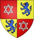 |
Blazon: Quarterly, at 1 and 4 Gules with two interlaced triangles of Argent, at 2 and 3 Or with a wolf rampant of Azure tongued and arm,ed in Gules.[13] |
Administration

List of Successive Mayors[14]
| From | To | Name | Party | Position |
|---|---|---|---|---|
| 1977 | Flavien Raybaud[15] | |||
| 2001 | 2020 | Aimé Bac[16] |
(Not all data is known)
Demography
There were 10 fires both in 1315 and in 1471 and a population of 312 in 1765 (Édouard Baratier, Georges Duby & Ernest Hildesheimer).[10]
In 2009 the commune had 74 inhabitants. The evolution of the number of inhabitants is known through the population censuses conducted in the commune since 1793. From the 21st century, a census of communes with fewer than 10,000 inhabitants is held every five years, unlike larger towns that have a sample survey every year.[Note 1]
| 1793 | 1800 | 1806 | 1821 | 1831 | 1836 | 1841 | 1846 | 1851 |
|---|---|---|---|---|---|---|---|---|
| 284 | 274 | 272 | 266 | 347 | 210 | 245 | 227 | 240 |
| 1856 | 1861 | 1866 | 1872 | 1876 | 1881 | 1886 | 1891 | 1896 |
|---|---|---|---|---|---|---|---|---|
| 244 | 223 | 196 | 181 | 168 | 180 | 182 | 176 | 144 |
| 1901 | 1906 | 1911 | 1921 | 1926 | 1931 | 1936 | 1946 | 1954 |
|---|---|---|---|---|---|---|---|---|
| 130 | 114 | 113 | 89 | 95 | 106 | 71 | 54 | 66 |
| 1962 | 1968 | 1975 | 1982 | 1990 | 1999 | 2006 | 2009 | - |
|---|---|---|---|---|---|---|---|---|
| 55 | 57 | 55 | 65 | 56 | 67 | - | 74 | - |
Sources : Ldh/EHESS/Cassini until 1962, INSEE database from 1968 (population without double counting and municipal population from 2006)


The demographic history of Angles is marked by a period of "stagnation" where the population was relatively stable at a high level. This period lasted until 1861. The rural exodus then caused a decline in population of long duration. By 1901 the town had lost more than half its population from the historical maximum in 1806.[17] The downward trend continued to 1970. Since then population growth has very slowly resumed.
Economy
Overview
In 2009 the active population was 27 people, including one unemployed.[18] These workers are mostly employed (19 of 26)[19] and mostly work outside the commune (20 workers of 26).[19] The only employment in the commune is in the tertiary sector.[20]
At 1 January 2011 the primary sector accounted for the largest share of active establishments in town (5 of 11), there are three companies in the secondary sector, and three in the tertiary sector.[20]
Agriculture
At the end of 2010 the primary sector (agriculture, forestry, fisheries) had 5 different establishments.[20]
The number of farms, according to the Agreste survey by the Ministry of Agriculture, remained stable in the 2000s at 3 which specialise in the breeding of sheep.[21] From 1988 to 2000 the agricultural area (UAA) fell significantly to 113 hectares from 603 hectares with most of the remaining in grass.[22] In contrast, the utilized agricultural area declined sharply in the 2000s: it went from 608 to 63 hectares.[21]
Industry
At the end of 2010 the secondary sector (industry and construction) had 3 establishments but had no employees.[20]
Service activities
At the end of 2010, the tertiary sector (trades and services) had 3 establishments (with only one employee).[20]
According to the Departmental Observatory of tourism, the tourism business is important for the town (considering the population) with between 1 and 5 tourists welcomed for each resident.[23] Most of the accommodation capacity is non-market.[24] Structures specifically to accommodate tourists are rare in Angles. There are:
- camping at the farm;[25]
- some furnished accommodation;[26][27]
- some cottages;[28]
- there are no hotels[29] or group accommodation[30]
Considering the low supply, it is ultimately the second homes that have the highest capacity:[31] 27 of 64 housing units in the commune are second homes (42%).[32]
Natural and technological risks
None of the 200 communes of the department is in a no seismic risk zone. The canton of Saint-André-les-Alpes to which Angles belongs is in zone 1b (low risk) according to the deterministic classification of 1991, based on the seismic history[33] and in zone 4 (medium risk) according to the probabilistic classification EC8 of 2011.[34] Angles commune is also exposed to four other natural hazards:[34]
- avalanche
- forest fire,
- flood (in the lower Torrent d'Angles)
- landslide: the commune has an average to high hazard in certain areas of its territory.[35]
The commune of Angles is also exposed to a risk of technological origin: the transport of dangerous goods by road.[36] The N202 national road can be used by trucks carrying dangerous goods[37] and pass within the limits of the commune.
No risk prevention plan for foreseeable natural disasters (PPR) exists for the commune[36] and a DICRIM has existed since 2011.[38]
The town has not been subject to any natural disasters.[34] The earthquake felt most strongly in Angles was at Chasteuil on 30 November 1951.[39]
Culture and heritage
Civil heritage

The commune has many buildings and structures that are registered as historical monuments:
- Angles Bridge (1947)
 [40]
[40] - Farmhouses (18th-20th centuries)[41]
- The Primary School (20th century)[42]
- An Agricultural Storehouse at Les Coutails (1893)[43]
- An Agricultural Storehouse at Les Perruches (18th century)[44]
- An Agricultural Storehouse at La Bourgade (18th century)[45]
- An Agricultural Storehouse at La Bourgade (18th century)[46]
- An Agricultural Storehouse at Les Perruches (19th century)[47]
- Agricultural Storehouses (18th-20th centuries)[48]
- A House at Moustier (18th century)[49]
- A House at Moustier (18th century)[50]
- A House at La Bourgade (18th century)[51]
- A House at La Bourgade (18th century)[52]
- A House at La Bourgade (18th century)[53]
- A House at La Bourgade (18th century)[54]
- A House at La Bourgade (18th century)[55]
- Houses (18th-19th century)[56]
- A Bread Oven (19th century)[57]
- A Fountain and Lavoir (Public laundry) (1898)[58]
- A Lavoir (Public laundry) (1932)[59]
- A Lavoir (Public laundry) (1932)[60]
- A Drinking Trough (18th century)[61]
Religious heritage

The commune has several religious buildings and structures that are registered as historical monuments:
- The Chapel of Notre-Dame-de-Bon-Secours (1870)[62] has a polygonal choir with cross ribs from the 16th or early 17th century.[63] It was in ruins at the end of the 19th century but was restored in the 1970s, contrary to the statements of diocesan investigations of the 19th century which gave a construction date of 1870.[6] The Furniture in the Chapel
 is registered as an historical object.[64]
 - The Parish Church of Notre-Dame (1686)[65] has a bell tower with polychrome tiles.[10][66] The Church contains a very large number of items that are registered as historical objects. For a complete list and links to descriptions (in French) click here.
- Oratories and Wayside Crosses (19th-20th centuries)[67]
- A Chapel of Saint-Jean also existed south of the village but it disappeared in the 19th century[6]
Gallery of Historical Objects in Angles
- Historical Monuments
-
Angles Bridge
[1] -
The Primary School
[2] -

The Drinking Trough
[3] -
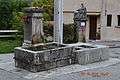
The Fountain and Lavoir
[4] -

Lavoir (Public Laundry)
[5] -

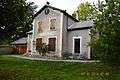
An old house in Angles
-
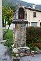
An Oratory
[6]
- ^ Cite error: The named reference
Bridgewas invoked but never defined (see the help page). - ^ Cite error: The named reference
Primarywas invoked but never defined (see the help page). - ^ Cite error: The named reference
Troughwas invoked but never defined (see the help page). - ^ Cite error: The named reference
Fountainwas invoked but never defined (see the help page). - ^ Cite error: The named reference
Lavoirwas invoked but never defined (see the help page). - ^ Cite error: The named reference
Oratorieswas invoked but never defined (see the help page).
- Historical Objects in the Church
-

Secondary Altar
-

A Triptych: Pieta
[1] -
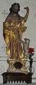
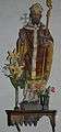
Statue: Saint John the Baptist
[2] -
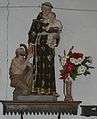
Statue: Charity of Saint Antoine of Padua and the child Jesus
[3] -

Statue: Saint Germaine
[4] -
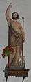
Statue: Saint John the Baptist
[5] -
Statue: Saint Joseph
[6] -
Statue: Saint Honorat
[7] -

Statue: Saint Antoine
[8] -
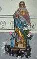
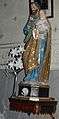
Statue: The Virgin
[9]
- ^ Ministry of Culture, Palissy IM04000650 Triptyche: Pieta (French)
- ^ Ministry of Culture, Palissy IM04001252 Statue: Saint John the Baptist (French)
- ^ Ministry of Culture, Palissy IM04001244 Statue: Charity of Saint Antoine of Padua and the child Jesus (French)
- ^ Ministry of Culture, Palissy IM04001243 Statue: Saint Germaine (French)
- ^ Ministry of Culture, Palissy IM04001242 Statue: Saint John the Baptist (French)
- ^ Ministry of Culture, Palissy IM04001241 Statue: Saint Joseph (French)
- ^ Ministry of Culture, Palissy IM04001238 Statue: Saint Honorat (French)
- ^ Ministry of Culture, Palissy IM04001237 Statue: Saint Antoine (French)
- ^ Ministry of Culture, Palissy IM04001236 Statue: The Virgin (French)
See also
External links
- Angles on the National Geographic Institute website (French)
- Angles on Lion1906
- Angles on Google Maps
- Angles on Géoportail, National Geographic Institute (IGN) website (French)
- Angles on the 1750 Cassini Map
- Angles on the INSEE website (French)
- INSEE (French)
Notes and references
Notes
- ↑ At the beginning of the 21st century, the methods of identification have been modified by law No. 2002-276 of 27 February 2002 , the so-called "law of local democracy" and in particular Title V "census operations" which allow, after a transitional period running from 2004 to 2008, the annual publication of the legal population of the different French administrative districts. For communes with a population greater than 10,000 inhabitants, a sample survey is conducted annually, the entire territory of these communes is taken into account at the end of the period of five years. The first "legal population" after 1999 under this new law came into force on 1 January 2009 and was based on the census of 2006.
References
- 1 2 3 Michel de La Torre, Alpes-de-Haute-Provence: the complete guide to 200 communes, Paris, Deslogis-Lacoste, coll. "Towns and Villages of France", 1989, Relié, 72 p. (non-paginated) (ISBN 2-7399-5004-7) (French)
- ↑ Roger Brunet, Canton de Saint-André-les-Alpes, The Treasure of Regions, consulted on 8 June 2013 (French)
- 1 2 3 Google Maps
- ↑ Ernest Nègre, General Toponymy of France: etymology of 35,000 place names, Genève : Librairie Droz, 1990. Volume III : Dialectal forms; French forms. Notices 26388-90, p 1447 (French)
- ↑ Bénédicte Fénié, Jean-Jacques Fénié, Provençale Toponymy, Éditions Sud-Ouest, 2002 (reprint), ISBN 978-2-87901-442-5, p. 68
- 1 2 3 4 5 Daniel Thiery, Angles, On the origins of churches and rural chapels of Alpes-de-Haute-Provence, published on 12 December 2010, online 15 December 2010, consulted on 25 June 2012 (French)
- ↑ Brigitte Beaujard, The cities of Eastern Gaul from the 3rd to the 7th centuries, Gallia, 63, 2006, CNRS éditions, p. 22-23 (French)
- ↑ At 13th, according to the Historical Atlas of Provence, p. 160
- ↑ Raymond Collier, Haute-Provence monumental and artistic, Digne, Imprimerie Louis Jean, 1986, 559 p., p 87 (French)
- 1 2 3 Baratier, Duby, Hildesheimer, p. 160
- ↑ Jean Nicolas, French Rebellion: popular movements and social conscience, 1661-1789, Paris : Gallimard, 2008. Collection Folio, ISBN 978-2-07-035971-4, p. 266-267 (French)
- ↑ Patrice Alphand, "The Popular Societies", The Revolution in the Lower Alps, Annals of Haute-Provence, bulletin from the Scientific and Literary society of Alpes-de-Haute-Provence, no 307, 1st trimester 1989, 108th year, p 296-298 (French)
- ↑ Louis de Bresc Arms of the communes of Provence 1866. Reprint - Marcel Petit CPM - Raphèle-lès-Arles 1994 (French)
- ↑ List of Mayors of France
- ↑ Flavien Raybaud was one of the 500 elected representatives who sponsored the candidacy of François Mitterrand (PS) at the French presidential election, 1981, cf Constitutional Council, List of elected candidates in the election of the President of the Republic, Official Journal of the French Republic of 15 April 1981, page 1046, available online, consulted on 29 July 2010
- ↑ Aimé Bac was one of 500 elected officials who supported Jean-Luc Mélenchon at the French presidential election, 2012, Constitutional Council, Lists of citizens who presented candidates for the election of the President of the Republic, Official Journal, 31 March 2012 (French)
- ↑ Christiane Vidal, Chronology and rhythms of depopulation in the department of Alpes de Haute-Provence since the beginning of the 19th century, Historic Provence, Vol. 21, No. 85, 1971, p. 288. (French)
- ↑ Insee, Local Dossier - Commune: Angles (04007), p. 5
- 1 2 Insee, Dossier local, p. 7
- 1 2 3 4 5 Insee, Dossier local, p. 15
- 1 2 Ministry of Agriculture, Techno-economic Orientation of exploitation, Agricultural censuses 2010 and 2000. (Place: N.B., the page is 4.4 Mb)
- ↑ Insee, Agricultiral enterprises in 1988 and 2000, Insee, 2012 (Page is 24.6 Mb)
- ↑ Departmental; Observatory of Tourism, Atlas of Tourist Accommodation, December 2008, p. 6 (French)
- ↑ Atlas of Tourist Accommodation, p. 7
- ↑ Atlas of Tourist Accommodation, p. 21, 22
- ↑ Atlas of Tourist Accommodation, p. 32
- ↑ Atlas of Tourist Accommodation, p. 36
- ↑ Atlas of Tourist Accommodation, p. 38
- ↑ Atlas of Tourist Accommodation, p. 11
- ↑ Atlas of Tourist Accommodation, p. 30
- ↑ Atlas of Tourist Accommodation, p. 44
- ↑ Insee, Local Dossier, p. 17
- ↑ Prefecture of Alpes-de-Haute-Provence, Departmental dossier on the major risks in Alpes-de-Haute-Provence (DDRM), 2008, p. 39 (French)
- 1 2 3 Ministry of Ecology, sustainable development, transport, and lodgings, Communal Notice on the Gaspar database, online 27 May 2011, consulted on 25 June 2012
- ↑ Prefecture, DDRM, p. 37
- 1 2 Prefecture of Alpes-de-Haute-Provence, Departmental dossier on the major risks in Alpes-de-Haute-Provence, p. 95
- ↑ Prefecture, DDRM, p. 80
- ↑ Dicrim for Angles Archived December 17, 2013, at the Wayback Machine., Dicrim database, consulted on 25 June 2011
- ↑ BRGM, Epicentres of seismic events (more than 40 km away) felt in Angles Archived March 3, 2016, at the Wayback Machine., Sisfrance, consulted on 25 June 2012 (French)
- ↑ Ministry of Culture, Mérimée IA04001079 Angles Bridge (French)

- ↑ Ministry of Culture, Mérimée IA04000580 Farmhouses (French)
- ↑ Ministry of Culture, Mérimée IA04000579 Primary School (French)
- ↑ Ministry of Culture, Mérimée IA04000578 Agricultural Storehouse at Les Coutails (French)
- ↑ Ministry of Culture, Mérimée IA04000577 Agricultural Storehouse at Les Perruches (French)
- ↑ Ministry of Culture, Mérimée IA04000576 Agricultural Storehouse at La Bourgade (French)
- ↑ Ministry of Culture, Mérimée IA04000575 Agricultural Storehouse at La Bourgade (French)
- ↑ Ministry of Culture, Mérimée IA04000574 Agricultural Storehouse at Les Perruches (French)
- ↑ Ministry of Culture, Mérimée IA04000573 Agricultural Storehouses (French)
- ↑ Ministry of Culture, Mérimée IA04000572 House at Moustier (French)
- ↑ Ministry of Culture, Mérimée IA04000571 House at Moustier (French)
- ↑ Ministry of Culture, Mérimée IA04000570 House at La Bourgade (French)
- ↑ Ministry of Culture, Mérimée IA04000569 House at La Bourgade (French)
- ↑ Ministry of Culture, Mérimée IA04000568 House at La Bourgade (French)
- ↑ Ministry of Culture, Mérimée IA04000567 House at La Bourgade (French)
- ↑ Ministry of Culture, Mérimée IA04000566 House at La Bourgade (French)
- ↑ Ministry of Culture, Mérimée IA04000565 Houses (French)
- ↑ Ministry of Culture, Mérimée IA04000417 Bread Oven (French)
- ↑ Ministry of Culture, Mérimée IA04000416 Fountain and Lavoir (French)
- ↑ Ministry of Culture, Mérimée IA04000415 Lavoir (French)
- ↑ Ministry of Culture, Mérimée IA04000414 Lavoir (French)
- ↑ Ministry of Culture, Mérimée IA04000413 Drinking Trough (French)
- ↑ Ministry of Culture, Mérimée IA04001111 Chapel of Notre-Dame-de-Bon-Secours (French)
- ↑ Raymond Collier, p 169
- ↑ Ministry of Culture, Palissy IM04001482 Furniture in the Chapel (French)
- ↑ Ministry of Culture, Mérimée IA04000230 Parish Church of Notre-Dame (French)
- ↑ Raymond Collier, p 222
- ↑ Ministry of Culture, Mérimée IA04000418 Oratories and Wayside Crosses (French)
| Wikimedia Commons has media related to Angles, Alpes-de-Haute-Provence. |