Valavoire
| Valavoire | ||
|---|---|---|
|
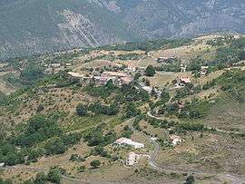
A general view of the village of valavoire, from above | ||
| ||
 Valavoire | ||
|
Location within Provence-A.-C.d'A. region  Valavoire | ||
| Coordinates: 44°16′48″N 6°04′01″E / 44.28°N 6.0669°ECoordinates: 44°16′48″N 6°04′01″E / 44.28°N 6.0669°E | ||
| Country | France | |
| Region | Provence-Alpes-Côte d'Azur | |
| Department | Alpes-de-Haute-Provence | |
| Arrondissement | Forcalquier | |
| Canton | La Motte-du-Caire | |
| Government | ||
| • Mayor (2008–2014) | Albert Martre | |
| Area1 | 16.81 km2 (6.49 sq mi) | |
| Population (2008)2 | 36 | |
| • Density | 2.1/km2 (5.5/sq mi) | |
| Time zone | CET (UTC+1) | |
| • Summer (DST) | CEST (UTC+2) | |
| INSEE/Postal code | 04228 / 04250 | |
| Elevation |
696–1,885 m (2,283–6,184 ft) (avg. 1,200 m or 3,900 ft) | |
|
1 French Land Register data, which excludes lakes, ponds, glaciers > 1 km² (0.386 sq mi or 247 acres) and river estuaries. 2 Population without double counting: residents of multiple communes (e.g., students and military personnel) only counted once. | ||

Valavoire is a commune in the Alpes-de-Haute-Provence department in southeastern France.
Population
| Historical population | ||
|---|---|---|
| Year | Pop. | ±% |
| 1793 | 267 | — |
| 1800 | 218 | −18.4% |
| 1806 | 250 | +14.7% |
| 1821 | 263 | +5.2% |
| 1831 | 234 | −11.0% |
| 1836 | 237 | +1.3% |
| 1841 | 203 | −14.3% |
| 1846 | 217 | +6.9% |
| 1851 | 218 | +0.5% |
| 1856 | 215 | −1.4% |
| 1861 | 200 | −7.0% |
| 1866 | 185 | −7.5% |
| 1872 | 164 | −11.4% |
| 1876 | 156 | −4.9% |
| 1881 | 160 | +2.6% |
| 1886 | 183 | +14.4% |
| 1891 | 179 | −2.2% |
| 1896 | 137 | −23.5% |
| 1901 | 157 | +14.6% |
| 1906 | 155 | −1.3% |
| 1911 | 146 | −5.8% |
| 1921 | 131 | −10.3% |
| 1926 | 104 | −20.6% |
| 1931 | 103 | −1.0% |
| 1936 | 75 | −27.2% |
| 1946 | 61 | −18.7% |
| 1954 | 97 | +59.0% |
| 1962 | 69 | −28.9% |
| 1968 | 45 | −34.8% |
| 1975 | 36 | −20.0% |
| 1982 | 45 | +25.0% |
| 1990 | 40 | −11.1% |
| 1999 | 27 | −32.5% |
| 2008 | 36 | +33.3% |
See also
References
| Wikimedia Commons has media related to Valavoire. |
This article is issued from Wikipedia - version of the 2/12/2016. The text is available under the Creative Commons Attribution/Share Alike but additional terms may apply for the media files.