Summit County, Ohio
| Summit County, Ohio | ||
|---|---|---|
|
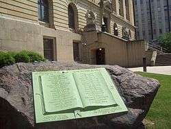
Summit County Courthouse | ||
| ||
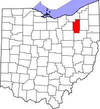 Location in the U.S. state of Ohio | ||
 Ohio's location in the U.S. | ||
| Founded | March 3, 1840[1][2] | |
| Named for | the highest elevation on the Ohio and Erie Canal | |
| Seat | Akron | |
| Largest city | Akron | |
| Area | ||
| • Total | 419.38 sq mi (1,086 km2) | |
| • Land | 412.08 sq mi (1,067 km2) | |
| • Water | 7.3 sq mi (19 km2), 1.7% | |
| Population | ||
| • (2010) | 541,781 | |
| • Density | 1,313/sq mi (507/km²) | |
| Congressional districts | 11th, 13th, 14th, 16th | |
| Time zone | Eastern: UTC-5/-4 | |
| Website |
www | |

Summit County is an urban county in the U.S. state of Ohio. As of the 2010 census, the population was 541,781[3] making it the fourth-most populous county in Ohio. Its county seat is Akron.[4] The county was formed on March 3, 1840, from portions of Medina, Portage and Stark Counties. It was named "Summit County" because the highest elevation on the Ohio and Erie Canal is located in the county.
Summit County is part of the Akron, OH Metropolitan Statistical Area, which is also included in the Cleveland-Akron-Canton, OH Combined Statistical Area.
Geography
According to the U.S. Census Bureau, the county has a total area of 419.38 square miles (1,086 km2), of which 412.08 square miles (1,067 km2) is land and 7.3 square miles (19 km2) (1.7%) is water.[5] The largest portion of Cuyahoga Valley National Park is located in the northern part of the county. The southern border of the former Connecticut Western Reserve passes through the southern part of the county, leading to jogs in the east and west borders of the county.
Major highways
 Interstate 76
 Interstate 77
 Interstate 80 / Ohio Turnpike
 Interstate 271
 Interstate 277
 Interstate 480
 U.S. Route 224
 Ohio State Route 8
Adjacent counties
- Cuyahoga County - northwest
- Geauga County - northeast
- Portage County - east
- Stark County - south
- Wayne County - southwest
- Medina County - west
National protected area
- Cuyahoga Valley National Park (also extends north into Cuyahoga County)
Government
Summit County, along with Cuyahoga County, is one of two of Ohio's 88 counties that have a charter government, as authorized by the Article X of the Ohio Constitution. Under its charter, rather than three elected commissioners, Summit County has an elected County Executive and an eleven-member County Council. Eight members of the council are elected from individual districts the other three are elected at large. Summit County also has an appointed Medical Examiner rather than an elected Coroner, and an elected Fiscal Officer, who exercises the powers and performs the duties of a county auditor, treasurer and recorder. The remaining officials are similar to the officials in other counties. They include the following:
- Clerk of Courts - Sandra Kurt (D) (elected)[6]
- Prosecuting Attorney - Sherri Bevan Walsh (D) (elected)
- Engineer - Alan Brubaker (D) (elected)
- Sheriff - Steve Barry (D) (elected)
- Fiscal Officer - Kristen Scalise (D) (elected)
Summit County currently has 14 Common Pleas judges. They are:
- Lynne S. Callahan (R),
- Paul J. Gallagher (D),
- Christine Croce (R),
- Amy Corrigall Jones (R),
- Alison McCarty (R),
- Tammy O'Brien (R),
- Scot Stevenson (R), [7]
- Mary Margaret Rowlands (D),
- Todd McKenney (R), and
- Thomas A. Teodosio (D)
- Linda Tucci Teodosio (D) (Juvenile Court Judge)
- Carol J. Dezso (D) (Domestic Relations Judge)
- John P. Quinn (D) (Domestic Relations Judge)
- Elinore Marsh Stormer (D) (Probate Judge)
Summit County Council
Summit County has an 11-member council. Three members are elected at-large in mid-term cycles, while eight members are elected from districts coinciding with the Presidential election. The current members of Summit County Council are:
- Clair Dickinson (D) (at-large)
- Elizabeth Walters (D) (at-large) [8]
- John Donofrio (D) (at-large)
- Nick Kostandaras (D) (District 1) President of Council
- John Schmidt (D) (District 2)
- Gloria Rodgers (R) (District 3)
- Jeff Wilhite (D) (District 4) [9]
- Tamela Lee (D) (District 5)
- Jerry Feeman (D) (District 6)
- Tim Crawford (D) (District 7)
- Paula Prentice (D) (District 8) [10]
County Executives
- John R. Morgan, 1981–1989
- Tim Davis, 1989–2001
- James B. McCarthy (D), 2001–2007[11]
- Russell M. Pry (D), 2007-2016[12][13][14][15][16]
- Ilene Shapiro (D), 2016-present
Demographics
| Historical population | |||
|---|---|---|---|
| Census | Pop. | %± | |
| 1840 | 22,560 | — | |
| 1850 | 27,485 | 21.8% | |
| 1860 | 27,344 | −0.5% | |
| 1870 | 34,674 | 26.8% | |
| 1880 | 43,788 | 26.3% | |
| 1890 | 54,089 | 23.5% | |
| 1900 | 71,715 | 32.6% | |
| 1910 | 108,253 | 50.9% | |
| 1920 | 286,065 | 164.3% | |
| 1930 | 344,131 | 20.3% | |
| 1940 | 339,405 | −1.4% | |
| 1950 | 410,032 | 20.8% | |
| 1960 | 513,569 | 25.3% | |
| 1970 | 553,371 | 7.8% | |
| 1980 | 524,472 | −5.2% | |
| 1990 | 514,990 | −1.8% | |
| 2000 | 542,899 | 5.4% | |
| 2010 | 541,781 | −0.2% | |
| Est. 2015 | 541,968 | [17] | 0.0% |
| U.S. Decennial Census[18] 1790-1960[19] 1900-1990[20] 1990-2000[21] 2010-2013[3] | |||
2000 census
As of the 2010 census, there were 541,781 people, 222,781 households, and 141,110 families residing in the county. The population density was 1,312.6 people per square mile (508/km²). There were 245,109 housing units at an average density of 559 per square mile (216/km²). The racial makeup of the county was 80.6% White, 14.4% Black or African American, 0.2% Native American, 2.2% Asian, 0.02% Pacific Islander, 0.5% from other races, and 2.1% from two or more races. 1.6% of the population were Hispanic or Latino of any race.[22] 24.6% were of German, 15.4% Irish, 9.6% English, 9.2% Italian, and 5.3% Polish ancestries according to Census 2010. 93.6% spoke English and 3.1% spoke another Indo-European language as their first language.[23]
There were 222,781 households out of which 27.0% had children under the age of 18 living with them, 45.3% were married couples living together, 13.6% had a female householder with no husband present, and 36.7% were non-families. 30.0% of all households were made up of individuals and 10.8% had someone living alone who was 65 years of age or older. The average household size was 2.39 and the average family size was 2.98.
The median income for a household in the county was $47,926, and the median income for a family was $60,849. The per capita income for the county was $26,676. About 13.8% of the population were living below the poverty line.[24][25]
In 2000, the county population was spread out with 25.00% under the age of 18, 8.20% from 18 to 24, 29.60% from 25 to 44, 23.00% from 45 to 64, and 14.10% who were 65 years of age or older. The median age was 37 years. For every 100 females there were 92.90 males. For every 100 females age 18 and over, there were 89.30 males.
2010 census
As of the 2010 United States Census, there were 541,781 people, 222,781 households, and 141,110 families residing in the county.[26] The population density was 1,312.6 inhabitants per square mile (506.8/km2). There were 245,109 housing units at an average density of 593.8 per square mile (229.3/km2).[27] The racial makeup of the county was 80.6% white, 14.4% black or African American, 2.2% Asian, 0.2% American Indian, 0.5% from other races, and 2.1% from two or more races. Those of Hispanic or Latino origin made up 1.6% of the population.[26] In terms of ancestry, 24.9% were German, 15.3% were Irish, 10.6% were English, 10.1% were Italian, 5.1% were Polish, and 4.5% were American.[28]
Of the 222,781 households, 29.8% had children under the age of 18 living with them, 45.3% were married couples living together, 13.6% had a female householder with no husband present, 36.7% were non-families, and 30.0% of all households were made up of individuals. The average household size was 2.39 and the average family size was 2.98. The median age was 40.0 years.[26]
The median income for a household in the county was $47,926 and the median income for a family was $62,271. Males had a median income of $47,892 versus $35,140 for females. The per capita income for the county was $26,676. About 10.0% of families and 13.8% of the population were below the poverty line, including 19.8% of those under age 18 and 8.0% of those age 65 or over.[29]
Politics
| Year | Republican | Democratic |
|---|---|---|
| 2016[30] | 43.0% 112,026 | 51.6% 134,256 |
| 2012 | 41.4% 111,001 | 57.0% 153,041 |
| 2008 | 40.7% 113,284 | 57.7% 160,858 |
| 2004 | 42.9% 118,558 | 56.7% 156,587 |
| 2000 | 43.0% 96,721 | 53.3% 119,759 |
| 1996 | 34.2% 73,555 | 52.1% 112,050 |
| 1992 | 32.1% 77,530 | 44.7% 107,881 |
| 1988 | 46.9% 101,155 | 52.2% 112,612 |
| 1984 | 51.0% 115,637 | 48.3% 109,569 |
| 1980 | 43.3% 92,299 | 48.1% 102,459 |
| 1976 | 38.4% 80,415 | 59.1% 123,711 |
| 1972 | 49.9% 112,419 | 48.2% 108,534 |
| 1968 | 39.6% 82,649 | 47.9% 100,068 |
| 1964 | 32.3% 68,000 | 67.7% 142,319 |
| 1960 | 49.6% 109,066 | 50.4% 110,852 |
Summit is a heavily Democratic county, only voting Republican in the 49 state sweeps by Richard Nixon and Ronald Reagan in 1972 and 1984 respectively.
Education

School districts
School Districts in Summit County do not strictly follow City and Township Corporation limits or township borders. Many School Districts in Summit County overlap community borders.[31] Below is a list of all public school districts in Summit County, Ohio.
- Akron Public School District
- Revere Local School District
- Copley–Fairlawn City School District
- Woodridge Local School District
- Hudson City School District
- Stow-Munroe Falls City School District
- Cuyahoga Falls City School District
- Tallmadge City School District
- Mogadore Local School District
- Springfield Local School District
- Coventry Local School District
- Green Local School District
- Manchester Local School District
- Barberton City School District
- Norton City School District
- Twinsburg City School District
- Nordonia Hills City School District
Colleges and universities
- University of Akron, Akron
- Kent State University Regional Academic Center, Twinsburg
Recreation
Communities
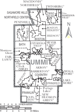
Cities
Villages
Townships
Defunct townships
Census-designated places
Unincorporated communities
See also
References
- ↑ "Ohio County Profiles: Summit County" (PDF). Ohio Department of Development. Retrieved 2007-04-28.
- ↑ "Summit County data". Ohio State University Extension Data Center. Retrieved 2007-04-28.
- 1 2 "State & County QuickFacts". United States Census Bureau. Retrieved February 11, 2015.
- ↑ "Find a County". National Association of Counties. Retrieved 2011-06-07.
- ↑ "2010 Census Gazetteer Files". United States Census Bureau. August 22, 2012. Retrieved February 11, 2015.
- ↑ http://www.ohio.com/news/break-news/summit-county-democrats-appoint-sandra-kurt-as-clerk-of-courts-1.654770
- ↑ http://www.governor.ohio.gov/MediaRoom/PressReleases/TabId/200/ArticleId/439/language/en-US/kasich-announces-appointment-to-summit-county-court-of-common-pleas-6-10-16.aspx
- ↑ http://www.ohio.com/news/local/regional-news-briefs-feb-6-2016-1.659986
- ↑ http://www.ohio.com/news/break-news/democrats-appoint-jeff-wilhite-to-summit-county-council-1.663080
- ↑ https://council.summitoh.net/
- ↑ McCarthy retired on June 30, 2007. "McCarthy, 67, Turns New Corner,". Akron Beacon Journal, 30 June 2007.
- ↑ Pry Biography
- ↑ On July 12, 2007, Pry was appointed by a majority vote of the Summit County Democratic Party's Central Committee to finish the remainder of McCarthy's second term. "Pry Named County Executive." Akron Beacon Journal, 13 July 2007
- ↑ On November 4, 2008, Pry was elected to a four-year term as County Executive with over 60% of the vote. "Republicans Lose More Ground in Summit Races, Democrats Gain Spot with Brubaker Beating Incumbent Engineer." Akron Beacon Journal, 6 November 2008
- ↑ On November 6, 2012, Pry was elected to a second four-year term as County Executive with over 62% of the vote. "Democrats Maintain Summit County Seats." Akron Beacon Journal, 7 November 2012
- ↑ Pry died in office on July 31, 2016 at age 58. http://www.cleveland.com/akron/index.ssf/2016/07/summit_county_executive_russ_p_1.html
- ↑ "County Totals Dataset: Population, Population Change and Estimated Components of Population Change: April 1, 2010 to July 1, 2015". Retrieved July 2, 2016.
- ↑ "U.S. Decennial Census". United States Census Bureau. Retrieved February 11, 2015.
- ↑ "Historical Census Browser". University of Virginia Library. Retrieved February 11, 2015.
- ↑ Forstall, Richard L., ed. (March 27, 1995). "Population of Counties by Decennial Census: 1900 to 1990". United States Census Bureau. Retrieved February 11, 2015.
- ↑ "Census 2000 PHC-T-4. Ranking Tables for Counties: 1990 and 2000" (PDF). United States Census Bureau. April 2, 2001. Retrieved February 11, 2015.
- ↑ http://factfinder2.census.gov/faces/tableservices/jsf/pages/productview.xhtml?pid=DEC_10_DP_DPDP1&prodType=table
- ↑ http://factfinder2.census.gov/faces/tableservices/jsf/pages/productview.xhtml?pid=ACS_10_1YR_DP02&prodType=table
- ↑ http://quickfacts.census.gov/qfd/states/39/39153.html
- ↑ http://factfinder2.census.gov/faces/tableservices/jsf/pages/productview.xhtml?pid=ACS_10_1YR_DP03&prodType=table
- 1 2 3 "DP-1 Profile of General Population and Housing Characteristics: 2010 Demographic Profile Data". United States Census Bureau. Retrieved 2015-12-27.
- ↑ "Population, Housing Units, Area, and Density: 2010 - County". United States Census Bureau. Retrieved 2015-12-27.
- ↑ "DP02 SELECTED SOCIAL CHARACTERISTICS IN THE UNITED STATES – 2006-2010 American Community Survey 5-Year Estimates". United States Census Bureau. Retrieved 2015-12-27.
- ↑ "DP03 SELECTED ECONOMIC CHARACTERISTICS – 2006-2010 American Community Survey 5-Year Estimates". United States Census Bureau. Retrieved 2015-12-27.
- ↑ "Dave Leip's Election Atlas Summit County, Ohio 2016". Retrieved 2016-11-30.
- ↑ "Map of School Districts near Akron, Ohio". AkronOhioMoms.com. 2013-05-29. Retrieved 2014-06-05.
External links
- Official Summit County page
- Akron-Summit Convention and Visitors Bureau
- Summit Memory, an online scrapbook capturing the history of Summit County, Ohio by the Akron-Summit County Public Library
 |
Cuyahoga County | Cuyahoga County | Geauga County | |
| Medina County | |
Portage County | ||
| ||||
| | ||||
| Wayne County | Stark County | Stark County |
Municipalities and communities of Summit County, Ohio, United States | ||
|---|---|---|
| Cities | | |
| Villages | ||
| Townships | ||
| CDPs | ||
| Unincorporated communities | ||
| Footnotes | ‡This populated place also has portions in an adjacent county or counties | |
Coordinates: 41°08′N 81°32′W / 41.13°N 81.53°W