Ashtabula County, Ohio
| Ashtabula County, Ohio | ||
|---|---|---|
|
| ||
| ||
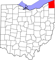 Location in the U.S. state of Ohio | ||
 Ohio's location in the U.S. | ||
| Founded | May 1, 1811 | |
| Named for | Lenape ashtepihële 'always enough fish to go around' | |
| Seat | Jefferson | |
| Largest city | Ashtabula | |
| Area | ||
| • Total | 1,368 sq mi (3,543 km2) | |
| • Land | 702 sq mi (1,818 km2) | |
| • Water | 666 sq mi (1,725 km2), 49% | |
| Population | ||
| • (2010) | 101,497 | |
| • Density | 145/sq mi (56/km²) | |
| Congressional district | 14th | |
| Time zone | Eastern: UTC-5/-4 | |
| Website |
www | |


Ashtabula County is the northeasternmost county in the U.S. state of Ohio. As of the 2010 census, the population was 101,497.[1] The county seat is Jefferson.[2] The county was created in 1808 and later organized in 1811.[3] The name[4] Ashtabula derives from Lenape language ashte-pihële, 'always enough (fish) to go around, to be given away';[5] contraction from apchi 'always'[6] + tepi 'enough' + hële (verb of motion).[7]
Ashtabula County comprises the Ashtabula, OH Micropolitan Statistical Area, which is also included in the Cleveland-Akron-Canton, OH Combined Statistical Area.
The county is probably best known for having seventeen covered bridges within the county limits, including both the longest and the shortest covered bridges in the United States. Grapes are a popular crop and there are several award winning wineries in the region owing to the favorable microclimate created by the nearby lake.[8] During the winter, Ashtabula County and neighboring Geauga and Lake Counties receives frequent lake effect snow and is part of the Southeastern Lake Erie Snowbelt.
History
After the discovery of the New World, the land that became Ashtabula County was originally part of the French colony of Canada (New France), which was ceded in 1763 to Great Britain and renamed Province of Quebec. In the late 18th century the land became part of the Connecticut Western Reserve in the Northwest Territory, then was purchased by the Connecticut Land Company in 1795.
Geography
_Auditor.svg.png)
According to the U.S. Census Bureau, the county has a total area of 1,368 square miles (3,540 km2), of which 702 square miles (1,820 km2) is land and 666 square miles (1,720 km2) (49%) is water.[9] It is the largest county in Ohio by area.[10]
Adjacent counties
Across Lake Erie lie Elgin and Norfolk Counties, Ontario, Canada (north).
- Erie County, Pennsylvania (northeast)
- Crawford County, Pennsylvania (east)
- Trumbull County (south)
- Geauga County (southwest)
- Lake County (west)
Major highways
-
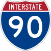 Interstate 90 is the main interstate route through Ashtabula County, spanning from the Ohio Turnpike between the Ohio-Indiana State Line and Elyria Township to the Ohio-Pennsylvania State Line. It contains five interchanges in the county at OH 534 (Exit 218), OH 45 (Exit 223), OH 11 and OH 46 (Exit 228), OH 84 and OH 193 (Exit 235), and OH 7 (Exit 241).
 -
 Ohio State Route 7 runs along the eastern part of the county as well as the state.
 -
 Ohio State Route 11 is a south-to-north state freeway in the county known as Lake to River Highway.
 -
 Ohio State Route 167 is a west-to-east state route in the northeastern part of the county running from Jefferson to the Pennsylvania State Line.
 -
 U.S. Route 6 Grand Army of the Republic Highway honoring American Civil War Veterans
 -
 U.S. Route 20 runs primarily along the coast of Lake Erie. It was the main west-to-east route in northern Ashtabula County, until I-90 was built.
 -
 U.S. Route 322 is the southernmost US route in the county that runs straight west to east until it approaches the Pymatuning Reservoir area and curves southeast before crossing the Ohio-Pennsylvania State Line.
Demographics
| Historical population | |||
|---|---|---|---|
| Census | Pop. | %± | |
| 1820 | 7,382 | — | |
| 1830 | 14,584 | 97.6% | |
| 1840 | 23,724 | 62.7% | |
| 1850 | 28,767 | 21.3% | |
| 1860 | 31,814 | 10.6% | |
| 1870 | 32,517 | 2.2% | |
| 1880 | 37,139 | 14.2% | |
| 1890 | 43,655 | 17.5% | |
| 1900 | 51,448 | 17.9% | |
| 1910 | 59,547 | 15.7% | |
| 1920 | 65,545 | 10.1% | |
| 1930 | 68,631 | 4.7% | |
| 1940 | 68,674 | 0.1% | |
| 1950 | 78,695 | 14.6% | |
| 1960 | 93,067 | 18.3% | |
| 1970 | 98,237 | 5.6% | |
| 1980 | 104,215 | 6.1% | |
| 1990 | 99,821 | −4.2% | |
| 2000 | 102,728 | 2.9% | |
| 2010 | 101,497 | −1.2% | |
| Est. 2015 | 98,632 | [11] | −2.8% |
| U.S. Decennial Census[12] 1790-1960[13] 1900-1990[14] 1990-2000[15] 2010-2013[1] | |||
2000 census
As of the census[16] of 2000, there were 102,728 people, 39,397 households, and 27,774 families residing in the county. The population density was 146 people per square mile (56/km²). There were 43,792 housing units at an average density of 62 per square mile (24/km²). The racial makeup of the county was 94.07% White, 3.16% Black or African American, 0.19% Native American, 0.34% Asian, 0.02% Pacific Islander, 0.85% from other races, and 1.36% from two or more races. 2.23% of the population were Hispanic or Latino of any race. 19.3% were of German, 11.6% Italian, 10.6% English, 10.5% Irish and 10.3% American ancestry according to Census 2000. 95.2% spoke English, 2.4% Spanish, and 0.8% German as their first language.[17]
There were 39,397 households out of which 32.40% had children under the age of 18 living with them, 54.80% were married couples living together, 11.40% had a female householder with no husband present, and 29.50% were non-families. 24.80% of all households were made up of individuals and 10.70% had someone living alone who was 65 years of age or older. The average household size was 2.56 and the average family size was 3.05.
In the county the population was spread out with 26.20% under the age of 18, 7.60% from 18 to 24, 28.00% from 25 to 44, 23.60% from 45 to 64, and 14.70% who were 65 years of age or older. The median age was 38 years. For every 100 females there were 95.10 males. For every 100 females age 18 and over, there were 92.10 males.
The median income for a household in the county was $35,607, and the median income for a family was $42,449. Males had a median income of $33,105 versus $22,624 for females. The per capita income for the county was $16,814. About 9.20% of families and 12.10% of the population were below the poverty line, including 17.10% of those under age 18 and 8.60% of those age 65 or over.
2010 census
As of the 2010 United States Census, there were 101,497 people, 39,363 households, and 26,495 families residing in the county.[18] The population density was 144.6 inhabitants per square mile (55.8/km2). There were 46,099 housing units at an average density of 65.7 per square mile (25.4/km2).[19] The racial makeup of the county was 92.7% white, 3.5% black or African American, 0.4% Asian, 0.2% American Indian, 1.1% from other races, and 2.1% from two or more races. Those of Hispanic or Latino origin made up 3.4% of the population.[18] In terms of ancestry, 24.9% were German, 15.8% were Irish, 12.6% were English, 11.1% were Italian, 10.0% were American, and 5.8% were Polish.[20]
Of the 39,363 households, 31.3% had children under the age of 18 living with them, 49.2% were married couples living together, 12.4% had a female householder with no husband present, 32.7% were non-families, and 26.9% of all households were made up of individuals. The average household size was 2.50 and the average family size was 3.01. The median age was 41.0 years.[18]
The median income for a household in the county was $42,139 and the median income for a family was $50,227. Males had a median income of $40,879 versus $30,156 for females. The per capita income for the county was $19,898. About 11.8% of families and 15.7% of the population were below the poverty line, including 21.7% of those under age 18 and 9.2% of those age 65 or over.[21]
Politics
| Year | Republican | Democratic |
|---|---|---|
| 2016 | 56.7% 22,755 | 37.8% 15,191 |
| 2012 | 42.4% 18,298 | 55.1% 23,803 |
| 2008 | 42.0% 18,949 | 55.5% 25,027 |
| 2004 | 46.3% 21,038 | 53.0% 24,060 |
| 2000 | 45.5% 17,940 | 50.2% 19,831 |
| 1996 | 34.3% 13,287 | 49.9% 19,341 |
| 1992 | 30.8% 13,254 | 43.8% 18,843 |
| 1988 | 45.8% 17,654 | 53.3% 20,536 |
| 1984 | 52.3% 21,669 | 46.7% 19,344 |
| 1980 | 49.0% 19,847 | 42.9% 17,363 |
| 1976 | 43.7% 16,885 | 54.1% 20,883 |
| 1972 | 59.0% 22,762 | 39.0% 15,052 |
| 1968 | 46.7% 17,058 | 45.8% 16,738 |
| 1964 | 35.4% 13,183 | 64.6% 24,104 |
| 1960 | 53.9% 22,406 | 46.1% 19,155 |
Ashtabula county had voted for the Democratic candidate for president in every election between 1988-2012; however, in 2016 it voted for Donald Trump. Trump captured the largest majority in the county since President Nixon in 1972.
Culture
Ashtabula County and neighboring Geauga, Lake and Trumbull Counties fostered a very large Finnish American community around the turn of the twentieth century, and as a result, the area is home to many Finnish Americans.
Ashtabula County has seventeen extant covered bridges. Of these, nine were constructed prior to 1900. See List of Ashtabula County covered bridges.
Communities

Cities
Villages
- Andover
- Geneva-on-the-Lake
- Jefferson (county seat)
- North Kingsville
- Orwell
- Roaming Shores
- Rock Creek
Townships
Census-designated places
Unincorporated communities
Notable people
- Chester H. Aldrich (1862–1924), governor of Nebraska 1911-1913[23]
- Brian Anderson, Cleveland Indians pitcher, originally from Geneva
- Charles Case (1817–1883), born in Austinburg, United States congressman from Indiana[24]
- Tammy Cochran, country music singer from Austinburg; biggest hit was "Angels in Waiting"
- Edwin Cowles (1825–1890), born in Austinburg, publisher of The Cleveland Leader, vice-president of the 1884 Republican National Convention[24]
- Joshua Reed Giddings (1795–1864), member of the U.S. House of Representatives and prominent opponent of slavery
- Francis Joseph Hall, was an American Protestant Episcopal theologian and author.
- Ken Meyer, head coach of the National Football League's San Francisco 49ers in 1977
- Urban Meyer, formerly the head football coach at the University of Florida, and current head football coach at The Ohio State University
- James Montgomery, (1814–1871), born in Ashtabula County, colonel in the American Civil War, raided several towns in Missouri and the American South[24]
- Danielle Nicolet, television, film, and voice actress born in Ashtabula
- Ransom Eli Olds, pioneer of the American automobile industry, for whom both the Oldsmobile and Reo brands were named
- Louis C. Shepard, American Civil War Medal of Honor recipient from Ashtabula County, buried in Lakeview Cemetery, Port Clinton, Ottawa County, Ohio
- Decius Wade, attorney, judge, writer, and politician who has been called the "Father of Montana Jurisprudence" for his role in establishing the common law and statutory law of the U.S. state of Montana
See also
References
- 1 2 "State & County QuickFacts". United States Census Bureau. Retrieved February 7, 2015.
- ↑ "Find a County". National Association of Counties. Archived from the original on 2011-05-31. Retrieved 2011-06-07.
- ↑ "Ohio: Individual County Chronologies". Ohio Atlas of Historical County Boundaries. The Newberry Library. 2007. Retrieved February 12, 2015.
- ↑ Cross, Tom (2008). Fishing Ohio: An Angler's Guide to Over 200 Fishing Spots in the Buckeye State. Lyons Press. p. 112. ISBN 978-0-7627-4326-1.
- ↑ Mahr, August C. (November 1959). "Practical Reasons for Algonkian Indian Stream and Place Names". Ohio Journal of Science. 59 (6): 365–375. ISSN 0030-0950. Retrieved 2016-08-03.
- ↑ "apchi". Lenape Talking Dictionary. Retrieved 2016-08-03.
- ↑ "tèpihële". Lenape Talking Dictionary. Retrieved 2016-08-03.
- ↑ "Ferrante Winery brings home the gold". The Ashtabula Wave. Retrieved 2016-04-01.
- ↑ "2010 Census Gazetteer Files". United States Census Bureau. August 22, 2012. Retrieved February 7, 2015.
- ↑ "Ashtabula, Lake are Ohio's largest and smallest counties by area". cleveland.com. January 18, 2011. Retrieved 30 December 2015.
- ↑ "County Totals Dataset: Population, Population Change and Estimated Components of Population Change: April 1, 2010 to July 1, 2015". Retrieved July 2, 2016.
- ↑ "U.S. Decennial Census". United States Census Bureau. Archived from the original on May 11, 2015. Retrieved February 7, 2015.
- ↑ "Historical Census Browser". University of Virginia Library. Retrieved February 7, 2015.
- ↑ Forstall, Richard L., ed. (March 27, 1995). "Population of Counties by Decennial Census: 1900 to 1990". United States Census Bureau. Retrieved February 7, 2015.
- ↑ "Census 2000 PHC-T-4. Ranking Tables for Counties: 1990 and 2000" (PDF). United States Census Bureau. April 2, 2001. Retrieved February 7, 2015.
- ↑ "American FactFinder". United States Census Bureau. Archived from the original on 2013-09-11. Retrieved 2008-01-31.
- ↑ "Archived copy". Archived from the original on 2013-08-15. Retrieved 2013-08-23.
- 1 2 3 "DP-1 Profile of General Population and Housing Characteristics: 2010 Demographic Profile Data". United States Census Bureau. Retrieved 2015-12-27.
- ↑ "Population, Housing Units, Area, and Density: 2010 - County". United States Census Bureau. Retrieved 2015-12-27.
- ↑ "DP02 SELECTED SOCIAL CHARACTERISTICS IN THE UNITED STATES – 2006-2010 American Community Survey 5-Year Estimates". United States Census Bureau. Retrieved 2015-12-27.
- ↑ "DP03 SELECTED ECONOMIC CHARACTERISTICS – 2006-2010 American Community Survey 5-Year Estimates". United States Census Bureau. Retrieved 2015-12-27.
- ↑ http://uselectionatlas.org/RESULTS/
- ↑ "Chester Hardy Aldrich". Find A Grave. Retrieved September 29, 2012.
- 1 2 3 Who Was Who in America, Historical Volume, 1607-1896. Chicago: Marquis Who's Who. 1963.
External links
| Wikivoyage has a travel guide for Ashtabula County. |
 |
Lake Erie | Erie County, Pennsylvania | | |
| Lake County | |
Crawford County, Pennsylvania | ||
| ||||
| | ||||
| Geauga County | Trumbull County |
Municipalities and communities of Ashtabula County, Ohio, United States | ||
|---|---|---|
| Cities | | |
| Villages | ||
| Townships | ||
| CDPs | ||
| Unincorporated communities | ||
Coordinates: 41°53′N 80°46′W / 41.89°N 80.76°W