Springfield, Ohio
| Springfield, Ohio | ||
|---|---|---|
| City | ||
| City of Springfield | ||
|
Fountain Square, Arcue Building in background. | ||
| ||
| Nickname(s): The Home City, The Rose City (City of Roses), The Champion City, The Field | ||
 Location within the state of Ohio | ||
 Location of Springfield in Clark County | ||
| Coordinates: 39°55′37″N 83°48′15″W / 39.92694°N 83.80417°WCoordinates: 39°55′37″N 83°48′15″W / 39.92694°N 83.80417°W | ||
| Country | United States | |
| State | Ohio | |
| County | Clark | |
| Founded | 1801 | |
| Incorporated | 1827 (village) | |
| – | 1850 (city) | |
| Government | ||
| • Mayor | Warren R. Copeland (D) | |
| Area[1] | ||
| • City | 25.50 sq mi (66.04 km2) | |
| • Land | 25.29 sq mi (65.50 km2) | |
| • Water | 0.21 sq mi (0.54 km2) | |
| Elevation | 978 ft (298 m) | |
| Population (2010)[2] | ||
| • City | 60,608 | |
| • Estimate (2012[3]) | 60,147 | |
| • Density | 2,396.5/sq mi (925.3/km2) | |
| • Metro | 138,333 | |
| Time zone | EST (UTC-5) | |
| • Summer (DST) | EDT (UTC-4) | |
| ZIP codes | 45501-45506 | |
| Area code(s) | 937 | |
| FIPS code | 39-74118[4] | |
| GNIS feature ID | 1065370[5] | |
| Website | www.ci.springfield.oh.us | |


Springfield is a city in the U.S. state of Ohio and the county seat of Clark County.[6] The municipality is located in southwestern Ohio and is situated on the Mad River, Buck Creek and Beaver Creek, approximately 45 miles (72 km) west of Columbus and 25 miles (40 km) northeast of Dayton. Springfield is home to Wittenberg University, a liberal arts college.
As of the 2010 census, the city had a total population of 60,608.[7] The Springfield Metropolitan Statistical Area had a population of 138,333 residents.[8] and the Dayton-Springfield-Greenville, OH Combined Statistical Area had 1,072,891 residents.[9] The Little Miami Scenic Trail, a paved rail-trail which is almost 80 miles long, goes from the Buck Creek Scenic Trailhead in Springfield south to Newtown, Ohio (near Cincinnati), and is popular with hikers and cyclists.
In 1983, Newsweek featured Springfield in its 50th anniversary issue, entitled, "The American Dream." It chronicled the impact of the past 50 years on five local families. In 2004, Springfield was chosen as an "All-America City". In 2010, Springfield ranked third worst in a national wellbeing survey conducted by The Gallup Organization.[10] In 2011, Springfield was named the "unhappiest city in America" by another Gallup survey.[11]In 2015, Springfield was ranked the least healthy city in Ohio by 24/7 Wall St.[12][13]
History
The villages of Peckuwe and Piqua were located near today's Springfield, Ohio, at 39° 54.5′ N, 83° 54.68′ W and 39° 54.501′ N, 83° 54.682′ W respectively, and were home to the Peckuwe and Kispoko Divisions of the Shawnee Tribe until the Battle of Piqua, August 8, 1780. The Piqua Sept of Ohio Shawnee Tribe have placed a traditional cedar pole in commemoration, located "on the southern edge of the George Rogers Clark Historical Park, in the lowlands in front of the park's 'Hertzler House.'"[14][15]
Springfield was founded by James Demint, a former teamster from Kentucky, in 1801. When Clark County was created from parts of Champaign, Madison and Greene counties, Springfield, named for Springfield, Massachusetts – which, at the time, was important for hosting the U.S. Federal Springfield Armory; enduring the Attack on Springfield during King Philip's War in 1675,; and Shays' Rebellion in 1787.
Springfield traces its early growth to the National Road, which ended in Springfield for approximately 10 years as politicians wrangled over the path it would continue. Dayton and Eaton wanted the road to veer south after Springfield, but President Andrew Jackson made the final decision to have the road continue straight west to Richmond, Indiana.[16]
 Springfield around 1830
 Springfield around 1900
During the mid-and-late 19th century, Springfield was dominated by industrialists including Oliver S. Kelly, Asa S. Bushnell, James Leffel, P. P. Mast and Benjamin H. Warder. Asa S. Bushnell built the Springfield, Ohio Bushnell Building[17] where the patent attorney to the Wright Brothers, Harry Aubrey Toulmin, Sr., wrote the 1904 patent to cover the invention of the airplane. To promote the products of his agricultural equipment company, P. P. Mast started the Farm and Fireside magazine. Mast’s publishing company – Mast, Crowell, and Kirkpatrick – grew to become Crowell-Collier Publishing Company best known for Collier's Weekly. In 1894, The Kelly Springfield Tire Company was founded.
At the turn of the 20th century Springfield became known as the "Home City." Several lodges including the Masonic Lodge, Knights of Pythias and Odd Fellows built homes for orphans and aged members of their order. Springfield also became known as "The Champion City". a reference to the Champion Farm Equipment brand manufactured by the Warder, Bushnell & Glessner Company, which was later absorbed into International Harvester in 1902. International remains in Springfield as Navistar International, a producer of medium to large trucks.
In 1902 A.B. Graham, then the superintendent of schools for Springfield Township in Clark County, established a "Boys' and Girls' Agricultural Club." Approximately 85 children from 10 to 15 years of age attended the first meeting on January 15, 1902 in Springfield, Ohio, in the basement of the Clark County Courthouse. This was the start of what would be called the "4-H Club" within a few years, quickly growing to a nationwide organization. (4-H stands for "Head, Heart, Hands, and Health").[18] The first "projects" included food preservation, gardening and elementary agriculture. Today, the Courthouse still bears a large 4H symbol under the flag pole at the front of the building to commemorate its part in founding the organization. The Clark County Fair is the second largest fair in the state (only the Ohio State Fair is larger) in large part to 4H still remaining very popular in the area.
On March 7, 1904, over a thousand residents formed a lynch mob, stormed the jail and removed prisoner Richard Dixon, a black man accused of murdering police officer Charles B. Collis. Richard Dixon was shot to death and then hung from a pole on the corner of Fountain and Main Street, where the mob continued to shoot his lifeless body. The mob then proceeded to burn much of the black area of town.[19] In February 1906, another mob formed and again burned the black section of town known as "the levee".[20] Sixty years later, Springfield was the first city in Ohio to have a black mayor, Robert Henry.[21]

From 1916 to 1926, 10 automobile companies operated in Springfield. Among them: The Bramwell, Brenning, Foos, Frayer-Miller, Kelly Steam, Russell-Springfield and Westcott. The Westcott, known as the car built to last, was a six-cylinder four-door sedan manufactured by Burton J. Westcott of the Westcott Motor Car Company. Burton and Orpha Westcott however, are better known for having contracted the world-renowned architect Frank Lloyd Wright to design their home in 1908 at 1340 East High Street. The Westcott House, a sprawling two-story stucco and concrete house has all the features of Wright's prairie style including horizontal lines, low-pitched roof, and broad eaves. It is the only Frank Lloyd Wright prairie style house in the state of Ohio. The property was purchased in 2000 by the Frank Lloyd Wright Building Conservancy (Chicago, IL), and as part of a prearranged plan, the house was then sold to a newly formed local Westcott House Foundation. The Westcott House Foundation managed the extensive 5-year, $5.3 million restoration, the house was fully restored to its original glory in October 2005, when it officially opened to the public for guided tours.

International Harvester (now Navistar), manufacturer of farm machinery and later trucks, became the leading local industry after Springfield native William Whiteley invented the self-raking reaper and mower, in 1856. It held that position, along with Crowell-Collier Publishing, throughout most of the next century.
The city is served by one daily newspaper, the Springfield News-Sun, and by one weekly newspaper, The Springfield Paper.
Geography
Springfield is located at 39°55′37″N 83°48′15″W / 39.92694°N 83.80417°W (39.927067, −83.804131).[22]
According to the United States Census Bureau, the city has a total area of 25.50 square miles (66.04 km2), of which, 25.29 square miles (65.50 km2) is land and 0.21 square miles (0.54 km2) is water.[1] The Clarence J. Brown Reservoir is located on the northeast outskirts of Springfield.
Demographics
| Historical population | |||
|---|---|---|---|
| Census | Pop. | %± | |
| 1810 | 593 | — | |
| 1820 | 1,868 | 215.0% | |
| 1830 | 1,080 | −42.2% | |
| 1840 | 2,062 | 90.9% | |
| 1850 | 5,108 | 147.7% | |
| 1860 | 7,002 | 37.1% | |
| 1870 | 12,652 | 80.7% | |
| 1880 | 20,730 | 63.8% | |
| 1890 | 31,895 | 53.9% | |
| 1900 | 38,253 | 19.9% | |
| 1910 | 46,921 | 22.7% | |
| 1920 | 60,840 | 29.7% | |
| 1930 | 68,743 | 13.0% | |
| 1940 | 70,662 | 2.8% | |
| 1950 | 78,508 | 11.1% | |
| 1960 | 82,723 | 5.4% | |
| 1970 | 81,926 | −1.0% | |
| 1980 | 72,563 | −11.4% | |
| 1990 | 70,487 | −2.9% | |
| 2000 | 65,358 | −7.3% | |
| 2010 | 60,608 | −7.3% | |
| Est. 2015 | 59,680 | [23] | −1.5% |
| [4][24][25][26][27] | |||
As of the 2000 census,[4] the median income for a household in the city was $32,193, and the median income for a family was $39,890. Males had a median income of $32,027 versus $23,155 for females. The per capita income for the city was $16,660. 16.9% of the population and 13.5% of families were below the poverty line. Out of the total population, 23.9% of those under the age of 18 and 9.6% of those 65 and older were living below the poverty line.
2010 census
As of the 2010 census,[7] there were 60,608 people, 24,459 households, and 14,399 families residing in the city. The population density was 2,693.7 people per square mile (1,039.6/km²). There were 28,437 housing units at an average density of 1,263.9 per square mile (487.8/km²). The racial makeup of the city was 75.2% White, 18.1% African American, 0.3% Native American, 0.8% Asian, 0.02% Pacific Islander, 4.0% from two or more races. Hispanic or Latino of any race were 3.0% of the population.
There are 24,459 households of which 26.3% have children under the age of 18 living with them, 34.4% are married couples living together, 18.6% have a female householder with no spouse present, 5.9% have a male householder with no spouse present, and 41.1% are non-families. 34.1% of all households are made up of individuals and 13.7% have someone living alone who is 65 years of age or older. The average household size is 2.38 and the average family size is 3.01.
In the population is spread out with 24.4% under the age of 18, 11.5% from 18 to 24, 24.2% from 25 to 44, 24.6% from 45 to 64, and 15.3% who are 65 years of age or older. The median age is 36 years. For every 100 females there are 90.9 males. For every 100 females age 18 and over, there are 86.2 males.
Crime
From 2012 through 2014, the city experienced a 21% increase in violent crime; from 618 per 100,000 persons to 750. Also during those years, occurrences of murder and non-negligent manslaughter steadily increased; from 5 to 7.[28][29][30] In 2015, Springfield's violent crime reached a 14-year high.[31][32]
Education
Springfield Public Schools enroll 8,604 students in public primary and secondary schools.[33] The district operates 16 public schools including ten elementary schools, three middle schools, one high school, and one alternative school.
Springfield is also home to Nightingale Montessori, a small private school using the methods from Dr. Montessori. The school was founded over thirty years ago, and has been educating many from Springfield, Clark County and other surrounding counties such as Greene, Clinton, Champaign, Franklin, Madison and Logan. The school accepts the Ed Choice scholarship, The Jon Peterson Scholarship and the Autism Scholarship. Students are admitted as early as 2 1/2 years old through high school.
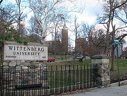
Springfield is home to two institutions of higher learning, Wittenberg University and Clark State Community College.
Wittenberg University is a Lutheran university that was founded in Springfield in 1845. It is a four-year private liberal arts university. It has more than two thousand students and a faculty of more than one hundred ninety five. It is situated on a campus of one hundred and fourteen rolling acres, shaded by many majestic trees. It is one of the most highly rated liberal arts universities in the nation, offering more than seventy majors, which include those in the sciences as well as in the arts. Wittenberg has more than one hundred fifty campus organizations, which include ten national fraternities and sororities. It has its own WUSO radio station and newspaper. The University is best known for its music department and its athletic endeavors. Wittenberg is also distinguished by its strong interdisciplinary programs such as East Asian Studies and Russian Area Studies. Recently majors in Management, Communication, Education are also becoming popular. The University made major renovations to its science facilities with the opening of the Barbara Deer Kuss Science Center in 2003.
The city is also home to Clark State Community College. Clark State Community College was founded in 1962 under the name of the Springfield and Clark County Technical Education Program as a technical education college for Clark County, Ohio and the surrounding area. It changed its name in 1966 to Clark County Technical Institute. The Ohio Board of Regents accredited it as Ohio's first technical college. It is now called Clark State Community College and has more than one thousand students. It offers courses in business, health, public services, engineering technologies, agriculture and general studies.
In popular culture
In the 1950 film Pagan Love Song, starring Esther Williams, actor Howard Keel played Hap "Hazard" Endicott, a school teacher from Springfield, Ohio.[34]
In 2009, during a scene of the movie X-Men Origins: Wolverine, "Springfield, Ohio" is listed in the scene caption as the location of a carnival where Victor Creed/Sabretooth finds Chris Bradley/Bolt working as a game booth attendant.
The Springfield News-Sun, The Wittenberg Torch, WEEC-FM radio, WUSO-FM radio are the city's main media organizations.
PBS' Market Warriors on September 17, 2012 featured the Springfield Antique Show and Flea Market.[35]
Notable people
The following are notable people born and/or raised in Springfield:
- Berenice Abbott – photographer
- Randy Ayers – assistant coach of the New Orleans Pelicans, former head coach of Ohio State and the Philadelphia 76ers
- Dave Burba – major league baseball player
- William R. Burnett – novelist and screenwriter
- Garvin Bushell – musician (saxophone, clarinet, etc.)
- Justin Chambers – former model and actor (in the cast of Grey's Anatomy)
- Lewis Strong Clarke – Louisiana sugar planter and Republican politician in the 19th century[36]
- Call Cobbs, Jr. – jazz pianist
- Jason Collier – professional basketball player
- Andrew Daniel – winner of Big Brother 5
- Trey DePriest - Linebacker of the Baltimore Ravens, 2 time NCAA National Champion of the Alabama Crimson Tide football team.
- Mike DeWine – former US Senator for Ohio and present Ohio Attorney General
- Marsha Dietlein – actress
- Adam Eaton (outfielder) - Major league baseball player
- Wayne Embry – professional basketball player
- Lillian Gish – actress from the silent film era and after
- Luther Alexander Gotwald Prof., D.D. – tried for and acquitted of Lutheran heresy at Wittenberg College in 1893.
- Albert Belmont Graham – Founder of 4H
- Harvey Haddix – major league baseball player
- Robert C. Henry – first African American mayor of any city
- Dustin Hermanson – major league baseball player
- Dave Hobson – Former U.S. Congressman for Ohio's Seventh District
- Alice Hohlmayer – All-American Girls Professional Baseball League player
- Griffin House – singer-songwriter
- Jimmy Journell – major league baseball player
- J. Warren Keifer – Civil War General and Speaker of the House
- Bradley Kincaid -America's first country music star. He performed on WLS, WBZ, and WLW.
- David Ward King – inventor of the King road drag
- Brooks Lawrence – major league baseball player
- John Legend (a.k.a. John Stephens) – singer, musician, R&B and neo-soul pianist
- Lois Lenski – author and illustrator of children's fiction, including Strawberry Girl
- Deborah Loewer – U.S. Navy flag officer
- Luke Lucas – major league baseball player
- Johnny Lytle – jazz musician
- Will McEnaney – major league baseball player, pitcher for the Cincinnati Reds
- Jeff Meckstroth – Multiple world champion bridge player
- Davey Moore – Boxer, World Featherweight Title holder 1959–1963
- Troy Perkins – professional soccer player
- Carl Ferdinand Pfeifer – Presidential aide
- Coles Phillips – early 20th century illustrator, inventor of the "fade-away" girl
- Robert Bruce Raup – Professor, Teachers College, Columbia University, writer, and critic of American Education system.
- Alaina Reed Hall – television actress, "227 (TV series)" and "Sesame Street"
- Cecil Scott – jazz clarinetist, tenor saxophonist, and bandleader
- Dick Shatto – professional Canadian football player
- Winant Sidle – U.S. Army Major General
- James Garfield Stewart, Supreme Court of Ohio the 109th Justice
- Dann Stupp – author
- Charles Thompson – jazz musician
- Tommy Tucker (a.k.a. Robert Higginbotham) – jazz musician
- W. D. Twichell – surveyor
- Christopher J. Waild – screenwriter
- Earle Warren – jazz saxophonist with Count Basie
- Walter L. Weaver – U.S. Representative from Ohio
- Rick White – major league baseball player
- Worthington Whittredge – Hudson River School painter
- Jonathan Winters – actor and comedian
See also
- Clark County Heritage Center, which houses the Clark County Historical Society museum, library, and archives.
- Clark County Public Library, which has its main and two other branches in Springfield.
- Springfield City School District, the school district that serves the city of Springfield
References
- 1 2 "US Gazetteer files 2010". United States Census Bureau. Retrieved 2013-01-06.
- ↑ "American FactFinder". United States Census Bureau. Retrieved 2013-01-06.
- ↑ "Population Estimates". United States Census Bureau. Retrieved 2013-06-17.
- 1 2 3 "American FactFinder". United States Census Bureau. Retrieved 2008-01-31.
- ↑ "US Board on Geographic Names". United States Geological Survey. 2007-10-25. Retrieved 2008-01-31.
- ↑ "Find a County". National Association of Counties. Retrieved 2011-06-07.
- 1 2 "American FactFinder2". Retrieved 2010-03-20.
- ↑ "Profile of General Population and Housing Characteristics: 2010". U.S. Census Bureau. Retrieved 2013-01-27.
- ↑ "Profile of General Population and Housing Characteristics: 2010". U.S. Census Bureau. Retrieved 2013-01-27.
- ↑ "Springfield third worst in wellness survey". Springfield News-Sun. May 14, 2011.
- ↑ McGinn, Andrew (January 12, 2012). "City rejects 'unhappiest' label as old, unfit". Springfield News-Sun. Retrieved 2012-03-19.
- ↑ Michael Cooper. "Springfield ranked least healthy city in Ohio by national report". Springfield News-Sun. Retrieved 2012-12-02.
- ↑ "The Least Healthy City in Every State". 24/7 Wall St. Retrieved 10 September 2015.
- ↑ "Peckuwe Shawnee Memorial Marker". HNdb.org, The Historical Marker Database. Retrieved 2013-02-17.
- ↑ "The Battle of Piqua Marker". HMdb.org, The Historical Marker Database. Retrieved 2013-02-17.
- ↑ Raitz, Karl B.; Thompson, George F. (1996). The National Road. JHU Press. p. 166. ISBN 978-0-8018-5155-1.
- ↑ History of the Bushnell Building Archived April 9, 2015, at the Wayback Machine.
- ↑ "4-H History." Available at: National4-hheadquarters.gov
- ↑ "Mob in Ohio Shoots...". New York Times. March 8, 1904.
- ↑ Ohiohistorycentral.org
- ↑ Knepper, George W. (January 2003). Ohio and Its People. Kent State University Press. p. 392. ISBN 978-0-87338-791-0.
- ↑ "US Gazetteer files: 2010, 2000, and 1990". United States Census Bureau. 2011-02-12. Retrieved 2011-04-23.
- ↑ "Annual Estimates of the Resident Population for Incorporated Places: April 1, 2010 to July 1, 2015". Retrieved July 2, 2016.
- ↑ "Population: Ohio" (PDF). 1930 US Census. U.S. Census Bureau. Retrieved 28 November 2013.
- ↑ "Number of Inhabitants: Ohio" (PDF). 18th Census of the United States. U.S. Census Bureau. Retrieved 22 November 2013.
- ↑ "Ohio: Population and Housing Unit Counts" (PDF). U.S. Census Bureau. Retrieved 22 November 2013.
- ↑ "Incorporated Places and Minor Civil Divisions Datasets: Subcounty Population Estimates: April 1, 2010 to July 1, 2012". U.S. Census Bureau. Retrieved 25 November 2013.
- ↑ "Crime in the United States by Metropolitan Statistical Area, 2012". FBI.
- ↑ "Crime in the United States by Metropolitan Statistical Area, 2013". FBI.
- ↑ "Crime in the United States by Metropolitan Statistical Area, 2014". FBI.
- ↑ "Violent crime in Springfield at 14-year high". Springfield News-Sun. March 22, 2016.
- ↑ Wichie, Allison. "Springfield residents fed up with crime, ready to fight back". Springfield News-Sun. Retrieved 3 May 2016.
- ↑ Great Schools.com. "Springfield City School District Profile". Retrieved 2008-10-06.
- ↑ "Database of Movie Dialogs (line 141)". 2011 BelaZebra.
- ↑ "Market Warriors Visits Springfield".
- ↑ "Clarke, Lewis Strong". Louisiana Historical Association, A Dictionary of Louisiana Biography (lahistory.com). Retrieved December 21, 2010.
External links
| Wikimedia Commons has media related to Springfield, Ohio. |
- City of Springfield
- Greater Springfield Convention and Visitor's Bureau
-
 Springfield travel guide from Wikivoyage
 -
 "Springfield, a city and the capital of Clark co., Ohio". The American Cyclopædia. 1879.
 |
Urbana, Ohio | Marysville, Ohio | | |
| Indianapolis, Indiana | |
Columbus, Ohio | ||
| ||||
| | ||||
| Dayton, Ohio | Wilmington, Ohio |
Municipalities and communities of Clark County, Ohio, United States | ||
|---|---|---|
| Cities |  | |
| Villages | ||
| Townships | ||
| CDPs | ||
| Unincorporated communities | ||
| Ghost towns | ||
| Footnotes | ‡This populated place also has portions in an adjacent county or counties | |