Bath Township, Summit County, Ohio
| Bath Township, Summit County, Ohio | |
|---|---|
| Township | |
|
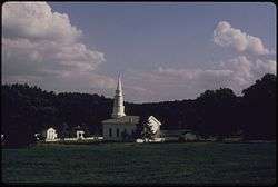
Hale Farm and Village in Bath | |
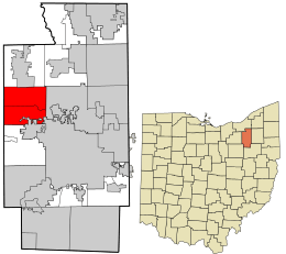 Location in Summit County and the state of Ohio. | |
| Coordinates: 41°9′29″N 81°38′0″W / 41.15806°N 81.63333°WCoordinates: 41°9′29″N 81°38′0″W / 41.15806°N 81.63333°W | |
| Country | United States |
| State | Ohio |
| County | Summit |
| Area | |
| • Total | 22.5 sq mi (58.2 km2) |
| • Land | 22.3 sq mi (57.7 km2) |
| • Water | 0.2 sq mi (0.4 km2) |
| Elevation[1] | 948 ft (289 m) |
| Population (2000) | |
| • Total | 9,635 |
| • Density | 432.4/sq mi (166.9/km2) |
| Time zone | Eastern (EST) (UTC-5) |
| • Summer (DST) | EDT (UTC-4) |
| ZIP code | 44210 |
| Area code(s) | 330 |
| FIPS code | 39-04248[2] |
| GNIS feature ID | 1086995[1] |
| Website | Bath Township |
Bath Township is one of the nine townships of Summit County, Ohio, United States. The 2000 census found 9,635 people in the township, a suburb of Akron.[3]
History
The township was originally known as Wheatfield when it was surveyed in 1808. The name was later changed to Hammondsburgh after Jason Hammond, who settled there in 1810. The name was changed to Bath when it fully separated from Richfield Township in 1818.[4] The origin of the name Bath is obscure;[5] it is said to have been so named for its brevity.[6]
In 1998, Bath Township formed a Joint Economic Development District (JEDD) with Akron and Fairlawn. The JEDD area has approximately 300 acres (1.2 km²) and is in the business district at the southern end of the township.[7]
Counties
Bath Township's land has been in the following counties:[8]
| Year | County |
|---|---|
| 1796 | Wayne |
| 1800 | Trumbull |
| 1808 | Portage |
| 1811 | No county |
| 1812 | Medina |
| 1840 | Summit |
Name
Statewide, other Bath Townships are located in Allen and Greene counties.
Geography
Located in the western part of the county, it borders the following townships and cities:
- Richfield Township – north
- Boston Township -– northeast
- Cuyahoga Falls – east
- Akron – southeast
- Copley Township – south
- Sharon Township, Medina County – southwest corner
- Granger Township, Medina County – west
- Hinckley Township, Medina County – northwest corner
Several populated places are located in Bath Township:
- The census-designated place of Montrose-Ghent, occupying the remainder of the southern part of the township, composed of the unincorporated communities of Ghent (in the center of the township) and Montrose (on the southern border with Copley Township)
- The unincorporated area of Hammond's Corners, in the north
Parts of the original Bath Township are now in Akron and Fairlawn.
It occupies most of survey Town 3, Range 12 in the Connecticut Western Reserve and is about 23 square miles (60 km²) in area.
Bath Township contains part of the Cuyahoga Valley National Park, whose main attraction within the township is the Hale Farm & Village, a historical community set in the 1800s.
Demographics
As of the census[9] of 2000, there were 9,635 people, 3,506 households, and 2,814 families residing in the township. The population density was 418.9 people per square mile (160.6/km²). There were 3,648 housing units at an average density of 158.6/sq mi (60.8/km²). The racial makeup of the township was 95.41% White, 1.59% African American, 0.04% Native American, 1.90% Asian, 0.11% from other races, and 0.94% from two or more races. Hispanic or Latino of any race were 0.80% of the population.
There were 3,506 households out of which 34.6% had children under the age of 18 living with them, 42.4% were married couples living together, 4.6% had a female householder with no husband present, and 19.7% were non-families. 17.2% of all households were made up of individuals and 8.93% had someone living alone who was 65 years of age or older. The average household size was 2.69 and the average family size was 3.06.
In the township the population was spread out with 25.5% under the age of 18, 2.5% from 20 to 24, 20.5% from 25 to 44, 22.5% from 45 to 64, and 17.0% who were 65 years of age or older. The median age was 44.7 years. For every 100 females there were 89.95 males. For every 100 females age 18 and over, there were 93.6 males.
The median income for a household in the township was $88,899, and the median income for a family was $99,202. Males had a median income of $74,464 versus $43,529 for females. The per capita income for the township was $49,032. About 0.6% of families and 1.3% of the population were below the poverty line, including 0.8% of those under age 18 and 2.7% of those age 65 or over.
Government
The township is governed by a non-partisan three-member board of trustees, who are elected in November of odd-numbered years to a four-year term beginning on the following January 1. Two are elected in the year after the presidential election and one is elected in the year before it. There is also an elected township fiscal officer, who serves a four-year term beginning on April 1 of the year after the election, which is held in November of the year before the presidential election. Vacancies in the fiscal officership or on the board of trustees are filled by the remaining trustees. In 2016, the board was composed of president Elaina Goodrich and members Becky Corbett and James Nelson, and the fiscal officer was Sharon Troike.[10] Vito Sinopoli was named Township Administrator on October 23, 2012.[11]
Major court cases are handled by the Summit County court system and minor ones by the Akron Municipal Court.
Bath Township is served by its own police and fire departments.
Infrastructure
Transportation
Bath Township has access to Interstate 77 at two points. There is a full cloverleaf that the township shares with Copley Township at the intersection with State Route 18. There is also an exit at Ghent Road. I-77 has rest areas on both sides in the northern part of the township. Interstate 271 passes through the township's northwest corner without providing access. Bath Township is served by two state highways: State Route 18 follows the western part of the original southern edge of the township, while State Route 21 shares Interstate 77 on a mostly north-south path through the township.[12]
Education
Most of Bath Township is in the Revere Local School District, with part of the township being in the Copley-Fairlawn City School District. The portion that is in the Revere district is also in the Cuyahoga Valley Joint Vocational School District. (Summit County Fiscal Officer, 2005). Old Trail School, an independent co-ed day school is situated in Cuyahoga Valley National Park.
Economy
InfoCision Management Corporation is based in Bath Township.
Arts and Culture
Bath Nature Preserve
In 1997 and 1998, a 404-acre (1.63 km2) former Firestone property was purchased by Bath Township and named Bath Nature Preserve. It contains grasslands, wetlands, ponds, streams, and mesophytic and riparian deciduous forests, which has through an agreement been used by The University of Akron as a research station.[13][14] It is used in ecology and biology research, and field trips are taken there by many biology classes to observe animals and collect samples for herbaria.[14] A map of the habitats in Bath Nature Preserve can be found here, and a list of species found and identified in the preserve can be found here.
Hale Farm and Village
Hale Farm and Village is a historic property of the Western Reserve Historical Society in Bath Township, Summit County, Ohio, United States. It is within the boundaries of the Cuyahoga Valley National Park. Hale Farm was the original homestead of Jonathan Hale, a Connecticut farmer who migrated to the Western Reserve in 1810.[15] In 1973 Hale Farm was listed on the National Register of Historic Places as the Jonathan Hale Homestead. The Hale House was built in 1825.[15]
Notable residents
- Michael Connell, high-level Republican consultant
- Jeffrey Dahmer, serial killer[16]
- LeBron James, basketball player for the Cleveland Cavaliers[17]
- Gilbert E. McKeeby, member of the Wisconsin State Senate
References
- 1 2 "US Board on Geographic Names". United States Geological Survey. 2007-10-25. Retrieved 2008-01-31.
- ↑ "American FactFinder". United States Census Bureau. Archived from the original on 2013-09-11. Retrieved 2008-01-31.
- ↑ Summit County, Ohio — Population by Places Estimates Ohio State University, 2007. Accessed 15 May 2007.
- ↑ "Bath Township Ohio". Bath Township Ohio. Retrieved 2012-06-07.
- ↑ Doyle, William B. (1908). Centennial History of Summit County, Ohio and Representative Citizens. Biographical Publishing Company. p. 102.
- ↑ Overman, William Daniel (1958). Ohio Town Names. Akron, OH: Atlantic Press. p. 9.
- ↑ "BATH-AKRON-FAIRLAWN JEDD". BATH-AKRON-FAIRLAWN JEDD. Archived from the original on February 5, 2007. Retrieved May 11, 2007.
- ↑ "Ohio Formation Maps". Ohio Formation Maps. Retrieved April 25, 2005.
- ↑ Extension Data Center, Dept of HCRD, The Ohio State University Ohio County Profiles. Retrieved May 1, 2005.
- ↑ Bath Township Administration Contact Information, Bath Township Homepage. Accessed 2012-10-10.
- ↑ "Bath trustees select Vito Sinopoli as next administrator". Akron Beacon Journal online. September 23, 2012. Retrieved October 25, 2012.
- ↑ Commercial Survey Company (2004). Official Street Atlas of Akron Summit and Portage Counties. Cleveland, Ohio: Commercial Survey Company. ISBN 1-879116-56-1.
- ↑ Bath Nature Preserve
- 1 2 Bath Nature Preserve
- 1 2 Hale Farm. Western Reserve Historical Society.
- ↑ Haidet, Ryan A. (August 15, 2014). "Tough sell? Jeffrey Dahmer boyhood home still on market". USA Today. Retrieved 31 January 2016.
- ↑ Cav's James in midst of building home fit for king usatoday.com, 2007-03-28. Accessed 2014-7-11.
Further reading
- The Ohio State University Department of Human and Community Resource Development (2003). Summit County. Retrieved April 29, 2005.
- Summit County Fiscal Officer, John Donofrio (2005). TAX YEAR 2004/COLLECTION YEAR 2005 FULL TAX RATE SUMMARY SHEET. Retrieved April 29, 2005.
- Grant, C.R.; et al. (1891). Illustrated Summit County Ohio. Akron Map & Atlas. LoC 91-077450.
External links
Municipalities and communities of Summit County, Ohio, United States | ||
|---|---|---|
| Cities | 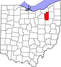 | |
| Villages | ||
| Townships | ||
| CDPs | ||
| Unincorporated communities | ||
| Footnotes | ‡This populated place also has portions in an adjacent county or counties | |