Hardin County, Ohio
| Hardin County, Ohio | |||
|---|---|---|---|
|
| |||
| |||
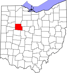 Location in the U.S. state of Ohio | |||
 Ohio's location in the U.S. | |||
| Founded | March 1, 1833 | ||
| Named for | John Hardin | ||
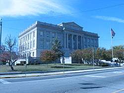
| Seat | Kenton | ||
| Largest city | Kenton | ||
| Area | |||
| • Total | 471 sq mi (1,220 km2) | ||
| • Land | 470 sq mi (1,217 km2) | ||
| • Water | 0.2 sq mi (1 km2), 0.1% | ||
| Population | |||
| • (2010) | 32,058 | ||
| • Density | 68/sq mi (26/km²) | ||
| Congressional district | 5th | ||
| Time zone | Eastern: UTC-5/-4 | ||
| Website |
www | ||

Hardin County is a county located in the U.S. state of Ohio. As of the 2010 census, the population was 32,058.[1] Its county seat is Kenton.[2] The county was created in 1820 and later organized in 1833.[3] It is named for John Hardin, an officer in the American Revolution.[4]
Geography
According to the U.S. Census Bureau, the county has a total area of 471 square miles (1,220 km2), of which 470 square miles (1,200 km2) is land and 0.2 square miles (0.52 km2) (0.1%) is water.[5]
Adjacent counties
- Hancock County (north)
- Wyandot County (northeast)
- Marion County (east)
- Union County (southeast)
- Logan County (south)
- Auglaize County (southwest)
- Allen County (northwest)
Demographics
| Historical population | |||
|---|---|---|---|
| Census | Pop. | %± | |
| 1820 | 22 | — | |
| 1830 | 210 | 854.5% | |
| 1840 | 4,598 | 2,089.5% | |
| 1850 | 8,251 | 79.4% | |
| 1860 | 13,570 | 64.5% | |
| 1870 | 18,714 | 37.9% | |
| 1880 | 27,023 | 44.4% | |
| 1890 | 28,939 | 7.1% | |
| 1900 | 31,187 | 7.8% | |
| 1910 | 30,407 | −2.5% | |
| 1920 | 29,167 | −4.1% | |
| 1930 | 27,635 | −5.3% | |
| 1940 | 27,061 | −2.1% | |
| 1950 | 28,673 | 6.0% | |
| 1960 | 29,633 | 3.3% | |
| 1970 | 30,813 | 4.0% | |
| 1980 | 32,719 | 6.2% | |
| 1990 | 31,111 | −4.9% | |
| 2000 | 31,945 | 2.7% | |
| 2010 | 32,058 | 0.4% | |
| Est. 2015 | 31,682 | [6] | −1.2% |
| U.S. Decennial Census[7] 1790-1960[8] 1900-1990[9] 1990-2000[10] 2010-2013[1] | |||
2000 census
At the 2000 census,[11] there were 31,945 people, 11,963 households and 8,134 families residing in the county. The population density was 68 per square mile (26/km²). There were 12,907 housing units at an average density of 27 per square mile (11/km²). The racial makeup of the county was 97.54% White, 0.70% Black or African American, 0.25% Native American, 0.43% Asian, 0.23% from other races, and 0.85% from two or more races. 0.78% of the population were Hispanic or Latino of any race. 96.9% spoke English and 1.4% German as their first language.
There were 11,963 households of which 31.40% had children under the age of 18 living with them, 55.00% were married couples living together, 8.90% had a female householder with no husband present, and 32.00% were non-families. 26.50% of all households were made up of individuals and 10.80% had someone living alone who was 65 years of age or older. The average household size was 2.51 and the average family size was 3.03.
24.30% of the population were under the age of 18, 15.40% from 18 to 24, 26.00% from 25 to 44, 21.30% from 45 to 64, and 12.90% who were 65 years of age or older. The median age was 33 years. For every 100 females there were 95.90 males. For every 100 females age 18 and over, there were 92.70 males.
The median household income was $34,440 and the median family income was $42,395. Males had a median income of $33,393 comppared with $21,695 for females. The per capita income for the county was $16,200. About 8.90% of families and 13.20% of the population were below the poverty line, including 15.20% of those under age 18 and 11.90% of those age 65 or over.
2010 census
As of the 2010 United States Census, there were 32,058 people, 11,762 households, and 7,950 families residing in the county.[12] The population density was 68.1 inhabitants per square mile (26.3/km2). There were 13,100 housing units at an average density of 27.8 per square mile (10.7/km2).[13] The racial makeup of the county was 96.7% white, 0.8% black or African American, 0.6% Asian, 0.2% American Indian, 0.5% from other races, and 1.3% from two or more races. Those of Hispanic or Latino origin made up 1.3% of the population.[12] In terms of ancestry, 33.0% were German, 15.1% were Irish, 13.2% were American, and 9.6% were English.[14]
Of the 11,762 households, 32.3% had children under the age of 18 living with them, 52.4% were married couples living together, 10.1% had a female householder with no husband present, 32.4% were non-families, and 26.7% of all households were made up of individuals. The average household size was 2.53 and the average family size was 3.05. The median age was 34.7 years.[12]
The median income for a household in the county was $41,343 and the median income for a family was $55,274. Males had a median income of $41,191 versus $32,313 for females. The per capita income for the county was $19,100. About 9.6% of families and 16.2% of the population were below the poverty line, including 18.5% of those under age 18 and 6.0% of those age 65 or over.[15]
Politics
| Year | Republican | Democrat |
|---|---|---|
| 2016 | 70.56% 8,717 | 23.64% 2,920 |
| 2012 | 60.06% 7,489 | 37.04% 4,619 |
| 2008 | 58.93% 7,749 | 38.12% 5,013 |
| 2004 | 63.03% 8,441 | 36.52% 4,891 |
| 2000 | 59.03% 7,124 | 37.76% 4,557 |
Transportation
Airports
Ada Airport (FAA LID: 0D7) is a privately owned, public-use airport located one nautical mile (1.85 km) northwest of the central business district of Ada, a village in Hardin County.
Hardin County Airport (FAA LID: I95) is the largest paved facility and is located 3 miles south of Kenton, Ohio on CR 135. The runway is 4,803 feet long at an elevation of 1,030 feet. Maintenance, fuel and storage are available.[17]
Major highways
Science
Currently there is a working Artesian aquifer operating in the county.
Media
Two newspapers, the daily The Kenton Times of Kenton and the weekly The Ada Herald of Ada, operate in Hardin County.
Radio stations include WKTN of Kenton and WONB of Ada, the radio station at Ohio Northern University.
WOCB-LP TV48 is a local Christian television station in downtown Kenton covering channels 39.1-39.4.[18]
Communities
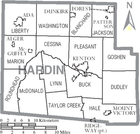
City
- Kenton (county seat)
Villages
Townships
Unincorporated communities
Notable people
From Kenton
- John R. Goodin, Democratic congressman from Kansas
- William Lawrence, Republican congressman involved with the attempt to impeach Andrew Johnson
- Jacob Parrott, first recipient of the Medal of Honor
- Paul Robinson, creator of the long-running "Etta Kett" comic strip for King Features Syndicate
- Brigadier General John (Mike) Murray[20]
From Ada
- Rollo May, an American existential psychologist.
- Lee Tressel, Father of former Ohio State University Football Coach Jim Tressel.
- John Berton, award-winning computer graphics animator and visual effects supervisor.
From Alger
- Ray Brown — Homestead Grays pitcher
From Dunkirk
- Willard Rhodes, ethnomusicologist (1901–1992)
- Dean Pees, NFL coach
See also
References
- 1 2 "State & County QuickFacts". United States Census Bureau. Retrieved February 8, 2015.
- ↑ "Find a County". National Association of Counties. Retrieved 2011-06-07.
- ↑ "Ohio: Individual County Chronologies". Ohio Atlas of Historical County Boundaries. The Newberry Library. 2007. Retrieved February 14, 2015.
- ↑ Gannett, Henry (1905). The Origin of Certain Place Names in the United States. Govt. Print. Off. p. 149.
- ↑ "2010 Census Gazetteer Files". United States Census Bureau. August 22, 2012. Retrieved February 8, 2015.
- ↑ "County Totals Dataset: Population, Population Change and Estimated Components of Population Change: April 1, 2010 to July 1, 2015". Retrieved July 2, 2016.
- ↑ "U.S. Decennial Census". United States Census Bureau. Retrieved February 8, 2015.
- ↑ "Historical Census Browser". University of Virginia Library. Retrieved February 8, 2015.
- ↑ Forstall, Richard L., ed. (March 27, 1995). "Population of Counties by Decennial Census: 1900 to 1990". United States Census Bureau. Retrieved February 8, 2015.
- ↑ "Census 2000 PHC-T-4. Ranking Tables for Counties: 1990 and 2000" (PDF). United States Census Bureau. April 2, 2001. Retrieved February 8, 2015.
- ↑ "American FactFinder". United States Census Bureau. Retrieved 2008-01-31.
- 1 2 3 "DP-1 Profile of General Population and Housing Characteristics: 2010 Demographic Profile Data". United States Census Bureau. Retrieved 2015-12-27.
- ↑ "Population, Housing Units, Area, and Density: 2010 - County". United States Census Bureau. Retrieved 2015-12-27.
- ↑ "DP02 SELECTED SOCIAL CHARACTERISTICS IN THE UNITED STATES – 2006-2010 American Community Survey 5-Year Estimates". United States Census Bureau. Retrieved 2015-12-27.
- ↑ "DP03 SELECTED ECONOMIC CHARACTERISTICS – 2006-2010 American Community Survey 5-Year Estimates". United States Census Bureau. Retrieved 2015-12-27.
- ↑ "Dave Leip's Atlas of U.S. Presidential Elections". Retrieved 2016-03-26.
- ↑ http://www.hardinohio.org/new/Transportation.aspx
- ↑ "The Central Ohio Association Of Christian Broadcasters".
- ↑ "Kansas Governor Nehemiah Green". National Governors Association. Retrieved September 29, 2012.
- ↑ http://www.army.mil/article/15459/
External links
Municipalities and communities of Hardin County, Ohio, United States | ||
|---|---|---|
| City | | |
| Villages | ||
| Townships | ||
| CDP | ||
| Unincorporated communities | ||
| Footnotes | ‡This populated place also has portions in an adjacent county or counties | |
Coordinates: 40°40′N 83°40′W / 40.66°N 83.66°W