Meigs County, Ohio
| Meigs County, Ohio | ||
|---|---|---|
 County courthouse in Pomeroy | ||
| ||
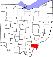 Location in the U.S. state of Ohio | ||
 Ohio's location in the U.S. | ||
| Founded | April 1, 1819[1] | |
| Named for | Return J. Meigs, Jr. | |
| Seat | Pomeroy | |
| Largest village | Middleport | |
| Area | ||
| • Total | 433 sq mi (1,121 km2) | |
| • Land | 430 sq mi (1,114 km2) | |
| • Water | 2.9 sq mi (8 km2), 0.7% | |
| Population | ||
| • (2010) | 23,770 | |
| • Density | 55/sq mi (21/km²) | |
| Congressional district | 6th | |
| Time zone | Eastern: UTC-5/-4 | |

Meigs County is a county located in the U.S. state of Ohio. As of the 2010 census, the population was 23,770.[2] Its county seat is Pomeroy.[3] The county is named for Return J. Meigs, Jr., the fourth Governor of Ohio.[4]
Geography
According to the U.S. Census Bureau, the county has a total area of 433 square miles (1,120 km2), of which 430 square miles (1,100 km2) is land and 2.9 square miles (7.5 km2) (0.7%) is water.[5] The Ohio River forms the eastern and southern boundaries of the county, the other side of which is located in West Virginia.
Meigs County lies in the Appalachian Plateau physiographic region of the Appalachian Mountains. The landscape is considered to be anywhere from gently rolling to rugged, typical of a dissected plateau. Elevations range from 1,020 feet (310 m) asl (above sea level) in the southwest to about 535 feet (163 m) asl in the far south central part of the county along the Ohio River. The majority of Meigs County is drained by two subwatersheds of the Ohio River, Shade River and Leading Creek. Another stream of note is Raccoon Creek, which flows through a small area of the northwestern corner of the county.[6]
Coal mining, both strip and underground, has been an important industry in Meigs County since the late 19th century, although mining of all types largely ceased by the 1990s. The effects of mining are still readily seen on the landscape today. Features such as high walls, spoil piles, and irregular topography are still prevalent. Many tributaries in the Leading Creek basin are plagued by acid mine drainage and sedimentation.
In 2009, Gatling, Ohio LLC invested $75 million to open a new coal mine and coal prep plant near Racine. It is capable of employing 120 to 150 miners, and is capable of producing 3.5 million marketable tons of coal per year.[7][8]
Climate
Meigs County's climate is considered humid continental, with warm to hot, humid summers and cool to cold, wet winters. Precipitation averages 41" annually, spread evenly throughout the year. High July temperatures average in the upper 80s F, while lows average in the low to mid 60s F. Temperatures above 90* F in the summer are common. January highs average about 40* F, with lows in the lower 20s. Temperatures around or even below 0* F occur during most winters. Snowfall averages 20–25", falling between late November and the first week of April.
The Ohio River creates a microclimate in its valley where temperatures tend to be moderated by the river, hence resulting in longer growing seasons compared to the rest of the county. Other microclimates, known as frost hollows or frost pockets, exist throughout the county in small isolated valleys. Nocturnal temperatures are often several degrees colder than the surrounding terrain.
Adjacent counties
- Athens County (north)
- Wood County, West Virginia (northeast)
- Jackson County, West Virginia (east)
- Mason County, West Virginia (southeast)
- Gallia County (southwest)
- Vinton County (west)
State protected areas
Demographics
| Historical population | |||
|---|---|---|---|
| Census | Pop. | %± | |
| 1820 | 4,480 | — | |
| 1830 | 6,158 | 37.5% | |
| 1840 | 11,452 | 86.0% | |
| 1850 | 17,971 | 56.9% | |
| 1860 | 26,534 | 47.6% | |
| 1870 | 31,465 | 18.6% | |
| 1880 | 32,325 | 2.7% | |
| 1890 | 29,813 | −7.8% | |
| 1900 | 28,620 | −4.0% | |
| 1910 | 25,594 | −10.6% | |
| 1920 | 26,189 | 2.3% | |
| 1930 | 23,961 | −8.5% | |
| 1940 | 24,104 | 0.6% | |
| 1950 | 23,227 | −3.6% | |
| 1960 | 22,159 | −4.6% | |
| 1970 | 19,799 | −10.7% | |
| 1980 | 23,641 | 19.4% | |
| 1990 | 22,987 | −2.8% | |
| 2000 | 23,072 | 0.4% | |
| 2010 | 23,770 | 3.0% | |
| Est. 2015 | 23,257 | [9] | −2.2% |
| U.S. Decennial Census[10] 1790-1960[11] 1900-1990[12] 1990-2000[13] 2010-2013[2] | |||
2000 census
As of the census[14] of 2000, there were 23,072 people, 9,234 households, and 6,574 families residing in the county. The population density was 54 people per square mile (21/km²). There were 10,782 housing units at an average density of 25 per square mile (10/km²). The racial makeup of the county was 97.73% White, 0.69% Black or African American, 0.27% Native American, 0.10% Asian, 0.25% from other races, and 0.96% from two or more races. 0.60% of the population were Hispanic or Latino of any race.
There were 9,234 households out of which 31.20% had children under the age of 18 living with them, 56.90% were married couples living together, 10.00% had a female householder with no husband present, and 28.80% were non-families. 25.00% of all households were made up of individuals and 11.70% had someone living alone who was 65 years of age or older. The average household size was 2.47 and the average family size was 2.94.
In the county, the population was spread out with 23.90% under the age of 18, 8.40% from 18 to 24, 27.70% from 25 to 44, 25.20% from 45 to 64, and 14.80% who were 65 years of age or older. The median age was 39 years. For every 100 females there were 94.70 males. For every 100 females age 18 and over, there were 92.80 males.
The median income for a household in the county was $27,287, and the median income for a family was $33,071. Males had a median income of $30,821 versus $19,621 for females. The per capita income for the county was $13,848. About 14.30% of families and 19.80% of the population were below the poverty line, including 26.30% of those under age 18 and 14.50% of those age 65 or over.
2010 census
As of the 2010 United States Census, there were 23,770 people, 9,557 households, and 6,698 families residing in the county.[15] The population density was 55.3 inhabitants per square mile (21.4/km2). There were 11,191 housing units at an average density of 26.0 per square mile (10.0/km2).[16] The racial makeup of the county was 97.4% white, 0.9% black or African American, 0.2% Asian, 0.2% American Indian, 0.1% from other races, and 1.2% from two or more races. Those of Hispanic or Latino origin made up 0.5% of the population.[15] In terms of ancestry, 25.1% were German, 14.3% were Irish, 13.9% were American, and 9.6% were English.[17]
Of the 9,557 households, 31.4% had children under the age of 18 living with them, 52.6% were married couples living together, 11.5% had a female householder with no husband present, 29.9% were non-families, and 25.3% of all households were made up of individuals. The average household size was 2.46 and the average family size was 2.91. The median age was 41.2 years.[15]
The median income for a household in the county was $33,407 and the median income for a family was $42,653. Males had a median income of $41,850 versus $27,271 for females. The per capita income for the county was $18,003. About 16.7% of families and 20.8% of the population were below the poverty line, including 31.9% of those under age 18 and 12.3% of those age 65 or over.[18]
Politics
| Year | Republican | Democrat |
|---|---|---|
| 2016 | 72.79% 7,309 | 22.51% 2,260 |
| 2012 | 57.69% 5,895 | 39.41% 4,027 |
| 2008 | 57.80% 6,015 | 39.34% 4,094 |
| 2004 | 58.23% 6,272 | 41.20% 4,438 |
| 2000 | 58.70% 5,750 | 37.51% 3,674 |
Education
Meigs county schools include:
- Meigs Elementary School
- Meigs Middle School
- Meigs High School
- Eastern High School
- Southern High School
Communities
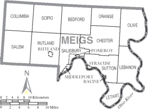

Villages
- Middleport
- Pomeroy (county seat)
- Racine
- Rutland
- Syracuse
Townships
Unincorporated communities
Notable people
- Mike Bartrum, an NFL long snapper/tight end
- Ambrose Bierce, an American editorialist, journalist, short story writer, fabulist and satirist best known for his short story "An Occurrence at Owl Creek Bridge".
- James Edwin Campbell, a poet, writer and educator
- David L. "Dave" Diles, a former American sports broadcaster and journalist
- Norman "Kid" Elberfeld, a Major League Baseball shortstop and manager
- William P. Halliday, steamboat captain, businessman, and railroad executive.
- Samuel Dana Horton, a bimetallism writer
- Reverend Fr. John Joseph Jessing, founder of the Pontifical College Josephinum in Columbus, Ohio
- Benny Kauff, Major League Baseball player
- Cy Morgan, a Major League Baseball pitcher
- Jorma Kaukonen, musician
See also
References
- ↑ "Ohio County Profiles: Meigs County" (PDF). Ohio Department of Development. Retrieved April 28, 2007.
- 1 2 "State & County QuickFacts". United States Census Bureau. Retrieved February 9, 2015.
- ↑ "Find a County". National Association of Counties. Archived from the original on May 31, 2011. Retrieved 2011-06-07.
- ↑ Gannett, Henry (1905). The Origin of Certain Place Names in the United States. U.S. Government Printing Office. p. 204.
- ↑ "2010 Census Gazetteer Files". United States Census Bureau. August 22, 2012. Retrieved February 9, 2015.
- ↑ Ohio Atlas & Gazetteer. Yarmouth, Me.: DeLorme. 1991. pp. 79–80, 87. ISBN 0-89933-233-1.
- ↑ "Pomeroy Daily Sentinel – Gatling investing million in mine facility". Mydailysentinel.com. Retrieved June 1, 2010.
- ↑ "Coal Ties / Meigs County producing coal once again " Entangled Citizens". Spurse.org. May 18, 2009. Retrieved June 1, 2010.
- ↑ "County Totals Dataset: Population, Population Change and Estimated Components of Population Change: April 1, 2010 to July 1, 2015". Retrieved July 2, 2016.
- ↑ "U.S. Decennial Census". United States Census Bureau. Archived from the original on May 11, 2015. Retrieved February 9, 2015.
- ↑ "Historical Census Browser". University of Virginia Library. Retrieved February 9, 2015.
- ↑ Forstall, Richard L., ed. (March 27, 1995). "Population of Counties by Decennial Census: 1900 to 1990". United States Census Bureau. Retrieved February 9, 2015.
- ↑ "Census 2000 PHC-T-4. Ranking Tables for Counties: 1990 and 2000" (PDF). United States Census Bureau. April 2, 2001. Retrieved February 9, 2015.
- ↑ "American FactFinder". United States Census Bureau. Archived from the original on September 11, 2013. Retrieved 2008-01-31.
- 1 2 3 "DP-1 Profile of General Population and Housing Characteristics: 2010 Demographic Profile Data". United States Census Bureau. Retrieved 2015-12-27.
- ↑ "Population, Housing Units, Area, and Density: 2010 - County". United States Census Bureau. Retrieved 2015-12-27.
- ↑ "DP02 SELECTED SOCIAL CHARACTERISTICS IN THE UNITED STATES – 2006-2010 American Community Survey 5-Year Estimates". United States Census Bureau. Retrieved 2015-12-27.
- ↑ "DP03 SELECTED ECONOMIC CHARACTERISTICS – 2006-2010 American Community Survey 5-Year Estimates". United States Census Bureau. Retrieved 2015-12-27.
- ↑ "Dave Leip's Atlas of U.S. Presidential Elections". Retrieved 2016-03-30.
Further reading
- Thomas William Lewis, History of Southeastern Ohio and the Muskingum Valley, 1788-1928. In Three Volumes. Chicago: S.J. Clarke Publishing Co., 1928.
External links
 |
Athens County | Wood County, West Virginia | | |
| Vinton County | |
Jackson County, West Virginia | ||
| ||||
| | ||||
| Gallia County | Mason County, West Virginia |
Municipalities and communities of Meigs County, Ohio, United States | ||
|---|---|---|
| Villages | | |
| Townships | ||
| CDP | ||
| Unincorporated communities | ||
| Ghost town | ||
Coordinates: 39°05′N 82°01′W / 39.08°N 82.02°W