Fulton County, Ohio
| Fulton County, Ohio | ||
|---|---|---|
 | ||
| ||
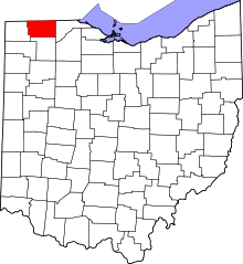 Location in the U.S. state of Ohio | ||
 Ohio's location in the U.S. | ||
| Founded | April 1, 1850[1] | |
| Named for | Robert Fulton | |
| Seat | Wauseon | |
| Largest city | Wauseon | |
| Area | ||
| • Total | 407 sq mi (1,054 km2) | |
| • Land | 405 sq mi (1,049 km2) | |
| • Water | 1.8 sq mi (5 km2), 0.4% | |
| Population | ||
| • (2010) | 42,698 | |
| • Density | 105/sq mi (41/km²) | |
| Congressional district | 5th | |
| Time zone | Eastern: UTC-5/-4 | |
| Website |
www | |


Fulton County is a county located in the U.S. state of Ohio. As of the 2010 census, the population was 42,698.[2] Its county seat is Wauseon.[3] The county was created in 1850 with land from Henry, Lucas, and Williams counties[4] and is named for Robert Fulton, inventor of the steamboat.[5]
History
The first seat of justice in Fulton County was Ottokee, located there because of its central location in the county. A wooden courthouse was built in 1851.[6]
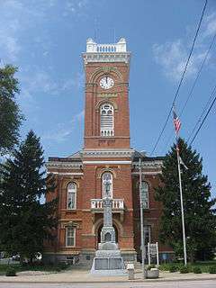
However, a railroad was built further south. Wauseon sprung up in 1854 when the railroad was extended to that point, and incorporated in 1859.[7] With the commercial success that the railroad brought to Wauseon, the citizens of the county voted to move the county seat to Wauseon in 1871.[6] The Fulton County Courthouse was built in 1872.[8]
|


Geography

Fulton County is part of the Toledo Metropolitan Area.
According to the U.S. Census Bureau, the county has a total area of 407 square miles (1,050 km2), of which 405 square miles (1,050 km2) is land and 1.8 square miles (4.7 km2) (0.4%) is water.[11]
Adjacent counties
- Lenawee County, Michigan (north)
- Lucas County (east)
- Henry County (south)
- Williams County (west)
- Hillsdale County, Michigan (northwest)
Protected Areas
- Fulton Pond Wildlife Area
- Goll Woods State Nature Preserve
- Harrison Lake State Park
- Maumee State Forest
- Tiffin River Wildlife Area
- Wabash Cannonball Trail
Demographics
| Historical population | |||
|---|---|---|---|
| Census | Pop. | %± | |
| 1850 | 7,781 | — | |
| 1860 | 14,043 | 80.5% | |
| 1870 | 17,789 | 26.7% | |
| 1880 | 21,053 | 18.3% | |
| 1890 | 22,023 | 4.6% | |
| 1900 | 22,801 | 3.5% | |
| 1910 | 23,914 | 4.9% | |
| 1920 | 23,445 | −2.0% | |
| 1930 | 23,477 | 0.1% | |
| 1940 | 23,626 | 0.6% | |
| 1950 | 25,580 | 8.3% | |
| 1960 | 29,301 | 14.5% | |
| 1970 | 33,071 | 12.9% | |
| 1980 | 37,751 | 14.2% | |
| 1990 | 38,498 | 2.0% | |
| 2000 | 42,084 | 9.3% | |
| 2010 | 42,698 | 1.5% | |
| Est. 2015 | 42,537 | [12] | −0.4% |
| U.S. Decennial Census[13] 1790-1960[14] 1900-1990[15] 1990-2000[16] 2010-2013[2] | |||
2000 census
As of the census[17] of 2000, there were 42,084 people, 15,480 households, and 11,687 families residing in the county. The population density was 104 people per square mile (40/km²). There were 16,232 housing units at an average density of 40 per square mile (15/km²). The racial makeup of the county was 95.65% White, 0.24% Black or African American, 0.26% Native American, 0.42% Asian, 0.04% Pacific Islander, 2.31% from other races, and 1.08% from two or more races. 5.76% of the population were Hispanic or Latino of any race.
There were 15,480 households out of which 37.10% had children under the age of 18 living with them, 63.20% were married couples living together, 8.20% had a female householder with no husband present, and 24.50% were non-families. 21.10% of all households were made up of individuals and 9.40% had someone living alone who was 65 years of age or older. The average household size was 2.69 and the average family size was 3.13.
In the county the population was spread out with 28.30% under the age of 18, 7.70% from 18 to 24, 28.70% from 25 to 44, 22.60% from 45 to 64, and 12.70% who were 65 years of age or older. The median age was 36 years. For every 100 females there were 95.60 males. For every 100 females age 18 and over, there were 93.30 males.
The median income for a household in the county was $44,074, and the median income for a family was $50,952. Males had a median income of $36,180 versus $25,137 for females. The per capita income for the county was $18,999. About 4.00% of families and 5.40% of the population were below the poverty line, including 6.10% of those under age 18 and 4.60% of those age 65 or over.
2010 census
As of the 2010 United States Census, there were 42,698 people, 16,188 households, and 11,942 families residing in the county.[18] The population density was 105.3 inhabitants per square mile (40.7/km2). There were 17,407 housing units at an average density of 42.9 per square mile (16.6/km2).[19] The racial makeup of the county was 94.9% white, 0.4% black or African American, 0.4% Asian, 0.3% American Indian, 2.4% from other races, and 1.5% from two or more races. Those of Hispanic or Latino origin made up 7.8% of the population.[18] In terms of ancestry, 45.5% were German, 11.9% were Irish, 10.7% were English, 6.9% were Polish, and 6.2% were American.[20]
Of the 16,188 households, 34.6% had children under the age of 18 living with them, 59.8% were married couples living together, 9.3% had a female householder with no husband present, 26.2% were non-families, and 22.3% of all households were made up of individuals. The average household size was 2.61 and the average family size was 3.05. The median age was 39.9 years.[18]
The median income for a household in the county was $50,717 and the median income for a family was $59,090. Males had a median income of $42,561 versus $30,070 for females. The per capita income for the county was $22,804. About 8.5% of families and 10.5% of the population were below the poverty line, including 14.4% of those under age 18 and 5.4% of those age 65 or over.[21]
Politics
| Year | Republican | Democrat |
|---|---|---|
| 2016 | 64.20% 13,709 | 28.42% 6,069 |
| 2012 | 55.08% 11,738 | 42.58% 9,073 |
| 2008 | 53.10% 11,689 | 44.97% 9,900 |
| 2004 | 62.13% 13,640 | 37.46% 8,224 |
| 2000 | 61.10% 11,546 | 36.01% 6,805 |
Transportation
Airport
Fulton County Airport is a public use airport located four nautical miles (5 mi, 7 km) north of the central business district of Wauseon, Ohio. It is owned by the Fulton County Commissioners.[23]
Highways
Communities

City
- Wauseon (county seat)
Villages
Townships
Census-designated places
Unincorporated communities
See also
References
- ↑ "Ohio County Profiles: Fulton County" (PDF). Ohio Department of Development. Retrieved 2007-04-28.
- 1 2 "State & County QuickFacts". United States Census Bureau. Retrieved February 7, 2015.
- ↑ "Find a County". National Association of Counties. Retrieved 2011-06-07.
- ↑ http://www.genealogyinc.com/ohio/maps/
- ↑ Gannett, Henry (1905). The Origin of Certain Place Names in the United States. Govt. Print. Off. p. 133.
- 1 2 Aldrich, Lewis Cass (1888). History of Henry and Fulton counties, Ohio : with illustrations and biographical sketches of some of its prominent men and pioneers. Syracuse, N. Y.: D. Mason & Co., Publishers. pp. 288–289.
- ↑ Reighard, Frank H. (1920). A Standard History of Fulton County, Ohio (Volume 1). Lewis Publishing Company. p. 209.
- ↑ Hellmann, Paul T. (May 13, 2013). "Historical Gazetteer of the United States". Routledge. p. 876. Retrieved 30 November 2013.
- ↑ Railroad & township map of Ohio (Map). Library of Congress. 1851. Retrieved 11 April 2016.
- ↑ J. A. Norton, Ohio commissioner of railroads & telegraphs (1890). Railroad map of Ohio (Map). Retrieved 11 April 2016.
- ↑ "2010 Census Gazetteer Files". United States Census Bureau. August 22, 2012. Retrieved February 7, 2015.
- ↑ "County Totals Dataset: Population, Population Change and Estimated Components of Population Change: April 1, 2010 to July 1, 2015". Retrieved July 2, 2016.
- ↑ "U.S. Decennial Census". United States Census Bureau. Retrieved February 7, 2015.
- ↑ "Historical Census Browser". University of Virginia Library. Retrieved February 7, 2015.
- ↑ Forstall, Richard L., ed. (March 27, 1995). "Population of Counties by Decennial Census: 1900 to 1990". United States Census Bureau. Retrieved February 7, 2015.
- ↑ "Census 2000 PHC-T-4. Ranking Tables for Counties: 1990 and 2000" (PDF). United States Census Bureau. April 2, 2001. Retrieved February 7, 2015.
- ↑ "American FactFinder". United States Census Bureau. Retrieved 2008-01-31.
- 1 2 3 "DP-1 Profile of General Population and Housing Characteristics: 2010 Demographic Profile Data". United States Census Bureau. Retrieved 2015-12-27.
- ↑ "Population, Housing Units, Area, and Density: 2010 - County". United States Census Bureau. Retrieved 2015-12-27.
- ↑ "DP02 SELECTED SOCIAL CHARACTERISTICS IN THE UNITED STATES – 2006-2010 American Community Survey 5-Year Estimates". United States Census Bureau. Retrieved 2015-12-27.
- ↑ "DP03 SELECTED ECONOMIC CHARACTERISTICS – 2006-2010 American Community Survey 5-Year Estimates". United States Census Bureau. Retrieved 2015-12-27.
- ↑ "Dave Leip's Atlas of U.S. Presidential Elections". Retrieved 2016-03-26.
- ↑ FAA Airport Master Record for USE (Form 5010 PDF). Federal Aviation Administration. Effective May 31, 2012.
External links
 |
Hillsdale County, Michigan | Lenawee County, Michigan | | |
| Williams County | |
Lucas County | ||
| ||||
| | ||||
| Henry County |
Municipalities and communities of Fulton County, Ohio, United States | ||
|---|---|---|
| City | | |
| Villages | ||
| Townships | ||
| CDPs | ||
| Unincorporated communities | ||
| Ghost towns | ||
| Footnotes | ‡This populated place also has portions in an adjacent county or counties | |
Coordinates: 41°36′N 84°07′W / 41.60°N 84.12°W