Tinambac, Camarines Sur
| Tinambac | |
|---|---|
| Municipality | |
 | |
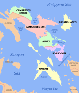
 Map of Camarines Sur showing the location of Tinambac | |
.svg.png) Tinambac Location within the Philippines | |
| Coordinates: 13°49′N 123°20′E / 13.82°N 123.33°ECoordinates: 13°49′N 123°20′E / 13.82°N 123.33°E | |
| Country | Philippines |
| Region | Bicol (Region V) |
| Province | Camarines Sur |
| District | 3rd district |
| Founded | 1888 |
| Barangays | 44 |
| Government[1] | |
| • Mayor | Ruel T. Velarde |
| Area[2] | |
| • Total | 351.62 km2 (135.76 sq mi) |
| Population (2015 census)[3] | |
| • Total | 67,572 |
| • Density | 190/km2 (500/sq mi) |
| Time zone | PST (UTC+8) |
| ZIP code | 4426 |
| IDD : area code | +63 (0)54 |
| Income class | 1st class; partially urban |
| Website |
tinambac |
Tinambac is a first class municipality in the province of Camarines Sur, Philippines. According to the 2015 census, it has a population of 67,572 people.[3]
Barangays
Tinambac is politically subdivided into 44 barangays.[2]
- Agay-Ayan
- Antipolo
- Bagacay
- Banga
- Bolaobalite
- Bani
- Bataan
- Binalay (Pob.)
- Buenavista
- Buyo
- Cagliliog
- Caloco
- Camagong
- Canayonan
- Cawaynan
- Daligan
- Filarca (Pob.)
- La Purisima (Pob.)
- Lupi
- Magsaysay (Camp 4)
- Magtang
- Mananao
- La Medalla (Mile 9)
- New Caaluan
- Olag Grande
- Olag Pequeño
- Old Caaluan
- Pag-Asa
- Pantat
- Sagrada (Camp 6)
- Salvacion
- San Antonio
- San Isidro (Pob.)
- San Jose (Tiltilan)
- San Pascual (Pob.)
- San Ramon (Camp 7)
- San Roque
- San Vicente
- Santa Cruz (Pob.)
- Sogod
- Tambang
- Tierra Nevada
- Union
- Salvacion Poblacion
History
The town of Tinambac was considered to be a trading center of villages surrounding the eastern side of Mt. Isarog . It was in this place where tobacco, then a prohibited product, was exchanged by the townspeople of Tinambac.
Its establishment as a separate municipality occurred during the latter part of the 18th century and this was known as the mission post of Himoragat. In 1829 when the Spanish administration divided the province of Camarines Sur into four districts, Tinambac fall under the District of Isarog.
A church was built atop a hill which still stands at present where the residents of this simple town give way to the celebration of its fiesta every 17th day of May. St. Pascual Baylon is the patron saint of this town.
Demographics
| Population census of Tinambac | ||
|---|---|---|
| Year | Pop. | ±% p.a. |
| 1990 | 46,570 | — |
| 1995 | 49,185 | +1.03% |
| 2000 | 55,608 | +2.67% |
| 2007 | 59,125 | +0.85% |
| 2010 | 62,435 | +2.00% |
| 2015 | 67,572 | +1.52% |
| Source: Philippine Statistics Authority[3][4][5] | ||
In the 2015 census, the population of Tinambac was 67,572 people,[3] with a density of 190 inhabitants per square kilometre or 490 inhabitants per square mile.
Bikol is the predominant language.
Economy
Total agricultural area is estimated to be 17,230 hectares (42,600 acres), 96% of which are planted with coconut. Only around 4% are devoted to rice, corn, banana and root crops. Fishponds cover around 464 hectares (1,150 acres) or 1.8% of the total agricultural area.
Communication facilities:
- 1 Post Office located in the Poblacion, staffed by a Post Master and mail carriers
- Telegraph service offered by local branch of National Telecommunications Office
- Branches of RCPI and LBC Air Cargo
- Land line communication facilities
References
- ↑ "Municipalities". Quezon City, Philippines: Department of the Interior and Local Government. Retrieved 9 January 2013.
- 1 2 "Province: CAMARINES SUR". PSGC Interactive. Makati City, Philippines: National Statistical Coordination Board. Retrieved 9 January 2013.
- 1 2 3 4 "Region V (BICOL REGION)". Census of Population (2015): Total Population by Province, City, Municipality and Barangay (Report). PSA. Retrieved 20 June 2016.
- ↑ "Region V (BICOL REGION)". Census of Population and Housing (2010): Total Population by Province, City, Municipality and Barangay (Report). NSO. Retrieved 29 June 2016.
- ↑ "Province of Camarines Sur". Municipality Population Data. LWUA Research Division. Retrieved 24 July 2013.
External links
| Wikimedia Commons has media related to Tinambac, Camarines Sur. |
- Philippine Standard Geographic Code
- Philippine Census Information
- Official site of the province of Camarines Sur/Tinambac
 |
Siruma | Philippine Sea | | |
| Mercedes, CamNorte / San Miguel Bay | |
Lagonoy Goa | ||
| ||||
| | ||||
| Calabanga |
| Administrative Divisions |
|  | ||||||
|---|---|---|---|---|---|---|---|---|
| Geography | ||||||||
| History | ||||||||
| Religion | ||||||||
| Public Utilities and Services |
| |||||||
| Transportation | ||||||||
| Education | ||||||||
| Landmarks |
| |||||||
Pili (capital) | |
| Municipalities | |
| Component city | |
| Independent component city |
|