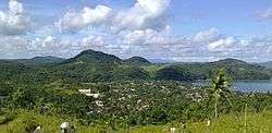
Jose Panganiban, Camarines Norte
| Jose Panganiban (Mambulao) | ||
|---|---|---|
| Municipality | ||
| Municipality of Jose Panganiban | ||
 | ||
| ||
| Motto: Alay sa Diyos at sa Bayan | ||
 Location within Camarines Norte | ||
.svg.png) Jose Panganiban Location within the Philippines | ||
| Coordinates: 14°18′N 122°42′E / 14.3°N 122.7°ECoordinates: 14°18′N 122°42′E / 14.3°N 122.7°E | ||
| Country |
| |
| Region | Bicol Region-Region V | |
| Province | Camarines Norte | |
| District | 1st district | |
| Founded (as Mambulao) | 1571 | |
| Founded (as Jose Panganiban) | December 1, 1934 | |
| Barangays | 27 | |
| Government[1] | ||
| • Type | Mayor–council government | |
| • Mayor | Ricarte Robledo Padilla (LP) | |
| • Vice Mayor | Ariel Mimay Non (LP) | |
| • Municipal Council |
Councilors
| |
| Area[2] | ||
| • Total | 214.44 km2 (82.80 sq mi) | |
| Elevation | 31 m (102 ft) | |
| Population (2015 census)[3] | ||
| • Total | 59,639 | |
| • Density | 259/km2 (670/sq mi) | |
| Demonym(s) | Mambuleños | |
| Time zone | PST (UTC+8) | |
| ZIP code | 4606 | |
| IDD : area code | +63 (0)54 | |
| Income class | 2nd class[2] | |
| Website |
mambulao | |

Jose Panganiban is a second-class municipality in the province of Camarines Norte, Philippines. According to the 2015 census, it has a population of 59,639 people.[3]
The town of Jose Panganiban was formerly known as Mambulao, a word taken from “mambulawan,” meaning bountiful in gold. It was renamed to honor Jose Maria Panganiban on December 1, 1934.[4]
Barangays
Jose Panganiban is politically subdivided into 27 barangays.
- Bagong Bayan
- Calero
- Dahican
- Dayhagan
- Larap
- Luklukan Norte
- Luklukan Sur
- Motherlode
- Nakalaya
- Osmeña
- Pag-Asa
- Parang
- Plaridel
- North Poblacion
- South Poblacion
- Salvacion
- San Isidro
- San Jose
- San Martin
- San Pedro
- San Rafael
- Santa Cruz
- Santa Elena
- Santa Milagrosa
- Santa Rosa Norte
- Santa Rosa Sur
- Tamisan
Demographics
| Population census of Jose Panganiban | ||
|---|---|---|
| Year | Pop. | ±% p.a. |
| 1960 | 27,144 | — |
| 1970 | 34,164 | +2.32% |
| 1980 | 30,260 | −1.21% |
| 1990 | 44,408 | +3.91% |
| 1995 | 45,396 | +0.41% |
| 2000 | 46,064 | +0.31% |
| 2007 | 49,028 | +0.86% |
| 2010 | 55,557 | +4.65% |
| 2015 | 59,639 | +1.36% |
| Source: Philippine Statistics Authority[3][5][4] | ||
In the 2015 census, the population of Jose Panganiban was 59,639 people,[3] with a density of 280 inhabitants per square kilometre or 730 inhabitants per square mile.
Economy
Mining
It is known that even before the colonizers came, Mambulao was already a flourishing mining town. It was the Spaniards, drawn by the rumor of immense gold deposits in the Mambulao-Paracale district, who mastered in exploring the gold mining potentials of these towns.
From the 1750s to 1800s, Paracale held the major Spanish mines, but due to its closure in the 1790s, its people were living in desultory gold washing, fishing and selling betel nut to Mambulao which has now became the mining center. During that time, there were plenty of small shops but there’s no rice fields and vegetable gardening. All necessities came from Ambos Camarines and Tayabas (Quezon). Fifteen years later, the mines of Mambulao were no longer open. There was still some haphazard gold washing by women of Indio Class whose husbands, it was alleged, gambled away their meager earning in card games run by the town mayor. But by 1818, the population was back to the levels of the 1790s and by the mid-1820s annual gold production levels ran as 3,200 ounces (90.7 kg.) worth Php. 44,000 at prevailing prices. By 1829, Camarines Norte was considered to be wealthy and populous enough to warrant separation as province of its own for the first time. But after the 1840s the mining and population declined. Dr. Fedor Jagor (in his book Travels in the Philippines and The former Philippines thru Foreign Eyes), a well known German traveler who visited Mambulao in 1859, reported that it was thinly populated and that the mining mania was already ruined.[6] From 1837 to 1876 the population of Mambulao and Paracale decreased by 30%.
From 1900 until the early twenties, Mambulao was a sleepy town, isolated from the other towns of Camarines Norte. During the gold bloom, it was dubbed as “Little Manila”, due to flourishing business operated by Filipinos, Chinese, Japanese, Syrians and many others. Dutch-born Filipino citizen Jan Hendrik Marsman operated two rich mines during the American occupation, a substantial dredging operation and the Philippines only smelter located in the Mambulao- Paracale district. The population quadrupled between 1918 and 1938. One of the most notable mining company to operate in this municipality is the Philippine Iron Mines, then the largest iron mine in Asia.
Mining companies operating in Jose Panganiban include:
- Philippine Iron Mines (defunct) 1925 to 1975, then biggest iron mine in Asia
- San Mauricio Mining Company (defunct) 1933
- Benguet Gold Mining Corporation (defunct)
- Motherlode Mining Company (defunct)
- J. G. Realty and Mining Company (defunct) 1987-1997
- Johson Gold Mining Corporation[7]
- Investwell Mining (mining arm of Isabelo Fonacier Mining)[8]
- Ferro Management and Consultancy Group Inc. (FMCGI) 2008
Jose Panganiban Special Economic Zone
- JPSEZ(1) Situated in Barangay Larap, Jose Panganiban created under Presidential Proclamation No. 508, s. 2003 [9]
- JPSEZ(2) Situated in Barangay Osmena, Jose Panganiban. Pan Century Surfactants Inc. under the Aditya Birla Group operates in the area.[10]
Infrastructure
Airport and Seaports
The International Port of Jose Panganiban (Latitude 14° 17’N Longitude 122° 42’E) is nearly 2 miles wide at the entrance between Calambayungan Island and Pinandungan Point and with sea distance to Manila of 468.10 nautical miles.The port is situated at Barangay Osmeña which is approximately five (5) kilometers away from the town proper of Jose Panganiban. The port serves as the passage of all water borne traffic to and from the Paracale mining area, Larap., Lucena, other Quezon town and the rest of Bicol and Visayas provinces. Copra, coconut oil and copra pellets used to be its principal exports.[11][12]
The Port of Larap Bay is a natural coastal harbor situated at Barangay Larap (Latitude 14° 18' 36" N Latutude 122° 39' 0" E), currently serving the needs of a local mining company. The harbor entrance is restricted due to swell.[13][14]
The Larap (Jose Panganiban) Airport (ICAO Code: RPUP), formerly operated by the Philippine Iron Mines, covers an area of approximately 35 hectares and with existing 1,400 meter stretched runway.[15] It is located at Latitude 14°17′28″N Longitude 122°38′46″E.
The nearest airports that operate regularly are Naga Airport (126 km away) in Camarines Sur and Legazpi Airport (216 km away) in Albay.
Public Land Transportation
The municipal's public transportation needs are provided by Tricycles, Jeepneys (Route: Downtown to Mountainous Villages), Vans (Route: Jose Panganiban to Daet, and Buses (Routes: Jose Panganiban to Daet) via Labo, Jose Panganiban to Tabaco, Albay via Naga City, and Jose Panganiban to Metro Manila). Philtranco, Superlines, and DLTB serves the Jose Panganiban-Metro Manila route.
Electricity and Water Supply
Jose Panganiban is being served by the National Power Corporation through CANORECO (Camarines Norte Electric Cooperative). A Coal Power Plant is set to be built by H and WB Asia Pacific Pte. Ltd. by 2016 which is expected to generate a total of 300 Megawatts of power supply using green coal technology.[16]
Water supply and treatment is provided by Jose Panganiban Water District, a local cooperative, via a system of pumps and pipes.
Communication
Mambulao Cable Television and JP Cable TV System provide digital cable services and internet connection throughout the municipality. Smart Communications, Globe Telecom, and Sun Cellular are the mobile, fixed-line, broadband, 3G and 4G internet service providers. International Calls are provided by the Local Government for free. Town FM 89.3 also broadcasts from the municipality.
Medical institutions
- Jose Panganiban Primary Hospital Services Coop.
- Barrios- Businos Medical Clinic and Hospital
Educational institutions

Post-secondary
- Camarines Norte State College - Jose Panganiban Campus (College of Engineering and Industrial Technology) formerly Camarines Norte School of Arts and Trades
- Roy Padilla Sr. (JP) Memorial Technical and Vocational Training Center (TESDA-accredited)
Public Secondary
- Jose Panganiban National High School
- Larap National High School
- Sta. Cruz National High School
- Milagros Villarasa-Torres National High School
Public Primary
West District:
|
East District:
|
Private Preschools
- Wonderkids Science Montessori School (formerly Wonderkids E-Learning Center)
- Good Sheperd Learning School
- St. Roch Children's
- Ave Maria Children Center
Places of interest
Historical landmarks
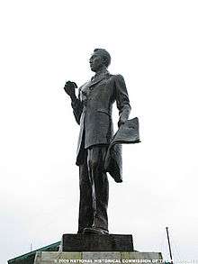
- Jose Maria Panganiban Monument- installed on February 1, 1985 by the National Historical Institute which contains the remains of the home-grown hero[17]
Churches
Roman Catholic Churches
- Parish of Our Lady of the Most Holy Rosary
- Parish of Saint Roch in Larap
Other Christian Churches
- Iglesia Ni Cristo
- Kingdom Hall of Jehovah's Witnesses
- City Of Praise
- The Church of Jesus Christ of Latter-day Saints
- Seventh-day Adventist
- Ang Dating Daan
- Assemblies of God
- Bible Centered Fellowship
- Body of Christ
Radio stations
- Hot FM 94.3 - Jose Panganiban (Manila Broadcasting Corporation)
- Town FM 89.3 - Jose Panganiban
Sister City
Gallery
 Jose Panganiban National High School
 Tree Planting Activity
 Hills above Barangay Motherlode
 Fil-Nippon Fountain of Friendship Park
 Jose Panganiban Elementary School
 Sunset viewed from a defunct seaport.
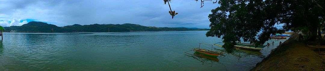
 Mambulao Bay
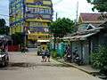 Street near JP Public Market
 Jose Rizal Street
 Rice Field inside JPNHS Campus
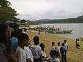 Mambulao beach during a fluvial parade
 PCSI compound in Barangay Osmena, Jose Panganiban
See also
References
- ↑ "Municipalities". Quezon City, Philippines: Department of the Interior and Local Government. Retrieved 31 December 2012.
- 1 2 "Province: CAMARINES NORTE". PSGC Interactive. Makati City, Philippines: National Statistical Coordination Board. Retrieved 31 December 2012.
- 1 2 3 4 "Region V (BICOL REGION)". Census of Population (2015): Total Population by Province, City, Municipality and Barangay (Report). PSA. Retrieved 20 June 2016.
- 1 2 "Municipal Profile". Official Website of Jose Panganiban. Retrieved 31 December 2012.
- ↑ "Region V (BICOL REGION)". Census of Population and Housing (2010): Total Population by Province, City, Municipality and Barangay (Report). NSO. Retrieved 29 June 2016.
- ↑ "Travels in the Philippines" (English) Reisen in den Philippinen. Chapman and Hall, London 1875
- ↑ http://www.johsongold.com/
- ↑ http://newsinfo.inquirer.net/38473/denr-execs-want-to-regulate-small-scale-mining
- ↑ http://www.gov.ph/2003/12/02/proclamation-no-508-s-2003/
- ↑ http://www.business-in-asia.com/philippines/ph_economic_zones.html
- ↑ http://www.pdosoluz.com.ph/terminal-port-of-jose-panganiban.html
- ↑ http://www.anchorageworld.com/content/jose-panganiban
- ↑ http://www.portarrivals.com/ports.asp?sec=Port&item=58090
- ↑ http://www.anchorageworld.com/content/larap-bay
- ↑ "Infrastracure".
- ↑ "Power Plant".
- ↑ http://nhcphistoricsites.blogspot.com/2011/11/jose-ma-panganiban-y-enverga-monument.html
- ↑ http://www.makati.gov.ph/portal/roms/roms_view.jsp?cat_no=040&view=cat
- ↑ http://camnortenews.com/page/?p=4481
External links
| Wikimedia Commons has media related to Jose Panganiban, Camarines Norte. |
- Jose Panganiban Official Website
- Jose Panganiban Website
- Philippine Standard Geographic Code
- Mambulaoans Worldwide Buzz
- Camarines Norte Online Store
- ONLINE ADVERTISEMENT
 |
Philippine Sea | | ||
| Capalonga | |
Paracale | ||
| ||||
| | ||||
| Labo |
Daet (capital) | |
| Municipalities | |