Buhi, Camarines Sur
| Buhi | ||
|---|---|---|
| Municipality | ||
 | ||
| ||
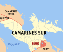 Map of Camarines Sur showing the location of Buhi | ||
.svg.png) Buhi Location within the Philippines | ||
| Coordinates: 13°26′N 123°31′E / 13.43°N 123.52°ECoordinates: 13°26′N 123°31′E / 13.43°N 123.52°E | ||
| Country | Philippines | |
| Region | Bicol Region (Region V) | |
| Province | Camarines Sur | |
| District | 5th District | |
| Founded | April 14, 1578 | |
| Barangays | 38 | |
| Government[1] | ||
| • Mayor | Margie M. Aguinillo (UNA) | |
| Area[2] | ||
| • Total | 246.65 km2 (95.23 sq mi) | |
| Population (2015 census)[3] | ||
| • Total | 77,143 | |
| • Density | 310/km2 (810/sq mi) | |
| Demonym(s) | Buhinon | |
| Time zone | PST (UTC+8) | |
| ZIP code | 4433 | |
| IDD : area code | +63 (0)54 | |
| Income class | 1st Class; Partially Urban | |
| Website |
www | |

Buhi, (Rinconada Bikol: Banwāan ka Buhi; English: Municipality of Buhi; Filipino: Bayan ng Buhi) is a town in the province of Camarines Sur, Philippines. According to the 2015 census, it has a population of 77,143 people.[3]
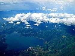
Buhi is not just known for Lake Buhi but it is likewise the home to the world's smallest commercial fish locally known as the sinarapan (Mystychtis luzonensis).
Geography

Buhi is located in the south-eastern part of the province of Camarines Sur. It is bound on the east by Mount Malinao, on the west by Mount Asog and Iriga City, on the north by Sagñay-Buhi mountain ranges and on the south by the low-lying ranges of Polangui, Albay, with the following coordinates: 13 degrees 25’ 32.4" north latitude and 123 degrees 30’ 49.1" east longitude. It is 75 kilometres (47 mi) north-east of Legaspi City and 53 kilometres (33 mi) and south of Naga City.
The municipality has been divided into five sectors, namely:
- The Poblacion
- The Lake/Mt. Asog sector
- the Road/cross road sector
- The Mountain sector
- The Malangkaw Sector
Topography
Buhi has generally mountainous and hilly surface, with 50% of its area having a slope of around 25%. The Poblacion located on the south shore of Lake Buhi, has gently rolling topography.
Mt. Malinao and Mt. Asog dominate the town's surface terrain whose highest elevations are 1,548 metres (5,079 ft) and 1,196 metres (3,924 ft) above main sea level respectively.
Climate
Buhi has a warm, humid climate. During the warmest months from March to June, temperatures reach 29.2 °C (84.6 °F). The weather cools off during the rainy season which last from August to February with an average temperature of 24.7 °C (76.5 °F).
Land use

A total area of 24,665 hectares (60,950 acres) is occupied by the municipality,[2] about 13,000 hectares of which are part of the watershed in Rinconada. 18,378 hectares (45,410 acres) of its land area are within the watershed declared as protected area by virtue of Presidential Proclamation No. 573 and Executive Order no. 224. All other areas are cultivated for agriculture, quarry and human settlement. Higher slopes east and north of Lake Buhi are predominantly forests and secondary brushland. Total area utilized as built-up areas is 448 hectares (1,110 acres).
Farmlands make up about 7,500 hectares (19,000 acres) of which about 2,375 hectares (5,870 acres) have access to irrigation, while 600 hectares (1,500 acres) are non-irrigated. About 2,811 hectares (6,950 acres) are open water spaces of Lake Buhi, and other lakes and streams.
Barangays
Buhi is politically subdivided into 38 barangays.[2]
- Antipolo
- Burocbusoc
- Cabatuan
- Cagmaslog
- Amlongan (Del Rosario)
- De La Fe
- Divino Rostro
- Ipil (Fatima)
- Gabas
- Ibayugan
- Igbac
- Iraya (Del Rosario)
- Labawon (Santa Teresita)
- De Los Angeles (Los Angeles)
- Monte Calvario
- Namurabod
- Sagrada Familia
- Salvacion
- San Antonio
- San Buenaventura (Poblacion)
- San Francisco (Parada)
- San Isidro
- San Jose Baybayon
- San Jose Salay
- Macaangay
- San Pascual (Poblacion)
- San Pedro (Poblacion)
- San Rafael
- San Ramon (Kaarayo)
- San Roque (Poblacion)
- San Vicente (Buraburan)
- Santa Clara(Poblacion)
- Santa Cruz
- Santa Elena (Poblacion)
- Santa Isabel
- Santa Justina (East and West)
- Lourdes (Our Lady of Lourdes)
- Tambo
- Tabao
- Marayag
History
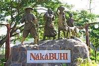
The town known today as Buhi began as a small settlement by refugees fleeing the outrage of Mayon Volcano hundreds of years ago. These people founded a permanent settlement in an area close to the lake and flourished as time passed.
The general exodus of people fleeing and being able to escape grave calamities such as Mayon's eruption was known in local vernacular as "naka-buhi". Local lore takes this as the most probable explanation as to how the town acquired its present name – Buhi. One version of local legend attributes the town being accorded the name to the time when the first Spaniards came and asked local settlers the name of the area. The local settlers misunderstood the question as how they came to be there and so gave the response "Naka-Buhi".
There were two patron saints with whom the town directed their devotion. The first was St. Francis of Assisi placed in the church made of wooden materials. Unfortunately, in 1730 the church was razed down by fire. It was, however, replaced by a stone structure built under the supervision of Rev. Fray Jose de Cerda. Another saint was installed, St. Anthony of Padua.
Demographics
| Population census of Buhi | ||
|---|---|---|
| Year | Pop. | ±% p.a. |
| 1990 | 57,496 | — |
| 1995 | 61,887 | +1.39% |
| 2000 | 67,762 | +1.96% |
| 2007 | 70,756 | +0.60% |
| 2010 | 73,809 | +1.55% |
| 2015 | 77,143 | +0.84% |
| Source: Philippine Statistics Authority[3][4][5] | ||
In the 2015 census, the population of Buhi, Camarines Sur, was 77,143 people,[3] with a density of 310 inhabitants per square kilometre or 800 inhabitants per square mile.
The total population was 70,756 in 2007, with a growth rate of about 2.1%. The total number of households was 13,238 and with an average household size of 5 persons. At the 2010 census, the population has increased to 73,809 persons. The local language is Buhinon, a dialect of Bikolano.
Literacy rate of Buhi is about 99%. The labor force is about 24,000 people strong, or 63% of economically productive people age 15 to 64 years old.
8 out of 10 persons are Roman Catholics; Iglesia ni Cristo makes up about 2% of the total population which is the largest minority religion in the municipality.
Language

Buhinon is the mother tongue of the majority of the population with Rinconada Bikol as its second language especially the folks residing on the eastern part of the municipality near Iriga City. Buhinon is clasiffied as one of the Albay Bikol languages, and the only one used in the province of Camarines Sur. Both Albay Bikol languages, which Buhinon is included, and Rinconada Bikol are members of Inland Bikol group of languages and share common vocabulary.
Economy
- Two thirds of the population depends on agriculture
- More than one-fifth of the total land area is devoted to agriculture primary crops are rice, corn, coconut,and abaca
- Rice grows in the vast field of Road sector while corn and abaca are being grown at Mountain sector
Infrastructure
Transportation
- Three major road networks that link the town to the adjacent province of Albay, Partido District and Iriga City. Most of its roads are gravel, especially those in the lake, road and mountain sectors.
- Presence of tricycles and jeepneys
- Presence of non-aircon and aircon buses
- Presence of motorized boats and bancas
- Presence of motorcycles called door-to-door
Utilities
Water supply:
- Rural Waterworks Multi-Purpose
- Cooperative provides the potable drinking water to at least 1,683 households in 7 suburban areas
Power and electricity:
- CASURECO III delivers electricity to 63% of households and business establishments and 97% of barangays
- Host to a 1.2 MW mini hydro-electric power plant of the National Power Corporation
Health
Presence of 1 public hospital; 3 private medical clinics; 38 health stations/centers; 3 pharmacies
Public Hospital:
- Buhi Community Hospital (temporarily closed by DOH)
Private Clinics:
- Claveria Clinic
- Portugal Clinic
- Sabio-Valenciano Clinic
Education
- No. of pre-schools: 33 public and 4 private schools
- No. of elementary schools: 33 public and 4 private schools
- No. of high schools: 3 private and 6 public schools
- No. of colleges: 1 state college
- No. of universities: 1 state university
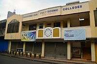
State Colleges:
- Camarines Sur Polytechnic Colleges
Public high schools:
- Sta. Justina National High School
- Tambo Barangay National High School
- San Vicente Barangay National High School
- Lourdes High School(New Open Public High school)
- Iraya High School (New Open Public High School)
- Salvacion High School (New Open Public High School)
- Sta. Isabel High School(Soon to Operate)
- John Mark Memorial High School
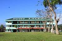
Private high schools:
- Buhi St. Joseph's Academy Inc. (formerly St. Joseph's Academy)
- Buhi Lyceum
- St. Bridget School
Private elementary schools:
- Buhi Institute Foundation
- Holy Child Educational Center (Buhi Branch)
- Buhi Lyceum
Media
Websites:
- Buhi Online: www.buhi.com[6]
FM Station
- 88.5 DWLF-FM Barita 88.5 (relay of Barita 97/7 FM Goa - Rural Airwaves Media Service (RAMS)
- 97.7 DWEA FM – Buhi (ASTIG ka dito!) Celebrates its 2nd year anniversary (September 11, 2010)
- 100.1 Radyo Natin-Buhi (Sa Buhi Ika Sana)
- 102.9 DWLR – Lauyay Radio
Notable people
Gallery
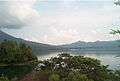 Lake Buhi
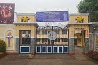
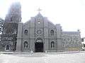 St. Francis of Assisi Parish Church
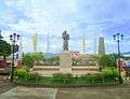 Patio
Patio Parish Pastoral Center
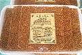 Baked "Sinarapan"

References
- ↑ "Municipalities". Quezon City, Philippines: Department of the Interior and Local Government. Archived from the original on 25 January 2013. Retrieved 10 January 2013.
- 1 2 3 "Province: CAMARINES SUR". PSGC Interactive. Makati City, Philippines: National Statistical Coordination Board. Retrieved 10 January 2013.
- 1 2 3 4 "Region V (BICOL REGION)". Census of Population (2015): Total Population by Province, City, Municipality and Barangay (Report). PSA. Retrieved 20 June 2016.
- ↑ "Region V (BICOL REGION)". Census of Population and Housing (2010): Total Population by Province, City, Municipality and Barangay (Report). NSO. Retrieved 29 June 2016.
- ↑ "Province of Camarines Sur". Municipality Population Data. LWUA Research Division. Retrieved 24 July 2013.
- ↑ http://www.buhi.com
External links
| Wikimedia Commons has media related to Buhi, Camarines Sur. |
- Buhi Online/BOL (www.buhi.com) – The 1st Online Community of Buhi (est. 1998)
- Philippine Standard Geographic Code
- Philippine Census Information
 |
Sagñay | | ||
| Iriga | |
Tiwi, Albay | ||
| ||||
| | ||||
| Polangui, Albay | Malinao, Albay |
Pili (capital) | |
| Municipalities | |
| Component city | |
| Independent component city |
|