San Fernando, Camarines Sur
| San Fernando | ||
|---|---|---|
| Municipality | ||
|
San Fernando Municipal Hall | ||
| ||
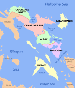
 Map of Camarines Sur showing the location of San Fernando | ||
.svg.png) San Fernando Location within the Philippines | ||
| Coordinates: 13°34′N 123°09′E / 13.57°N 123.15°ECoordinates: 13°34′N 123°09′E / 13.57°N 123.15°E | ||
| Country | Philippines | |
| Region | Bicol (Region V) | |
| Province | Camarines Sur | |
| District | 1st district | |
| Founded | 1813 | |
| Barangays | 22 | |
| Government[1] | ||
| • Mayor | Fermin "Magdalo" Mabolo | |
| Area[2] | ||
| • Total | 71.76 km2 (27.71 sq mi) | |
| Population (2015 census)[3] | ||
| • Total | 35,258 | |
| • Density | 490/km2 (1,300/sq mi) | |
| Time zone | PST (UTC+8) | |
| ZIP code | 4415 | |
| IDD : area code | +63 (0)54 | |
| Income class | 4th class; rural | |


San Fernando is a fourth class municipality in the province of Camarines Sur, Philippines. According to the 2015 census, it has a population of 35,258 people.[3]
Barangays
San Fernando is administratively subdivided into 22 barangays.[2]
- Alianza
- Beberon
- Bical
- Bocal
- Bonifacio (Pob.)
- Buenavista (Pob.)
- Calascagas
- Cotmo
- Daculang Tubig
- Del Pilar (Pob.)
- Gñaran
- Grijalvo
- Lupi
- Maragñi
- Pamukid
- Pinamasagan
- Pipian
- Planza
- Rizal (Pob.)
- San Joaquin
- Santa Cruz
- Tagpocol
History
Ambos Camarines included among its "visitas" or barrios the town of San Fernando. The town, however, also remained as a "barrio" of Milaor for more than 230 years.
Pueblo de San Fernando separated from Milaor and was established as an independent pueblo on 1 January 1813.
The residents of this old settlement were noted for their religious devotion as manifested by their honor and dedication to San Fernando, the town's patron saint. This patron of San Fernando, according to historical records, was however not the original patron saint for whom the first settlers built the chapel. They actually built a chapel in honor of their patron saint San Fernando. However, for some unusual reasons, the image was lost after it had been transferred into the newly erected chapel. It was said that efforts were wielded to find the missing icon but it all ended into great frustration as the lost image of San Fernando was not found. One resident from the old site where the image was housed later informed the people of San Fernando that the image returned to its original location. With this incident, the Teniente del Barrio then decided to install the image of another saint, Saint John the Baptist. Their celebration of the town and parish fiesta is held every 24 June.
Demographics
| Population census of San Fernando | ||
|---|---|---|
| Year | Pop. | ±% p.a. |
| 1990 | 20,608 | — |
| 1995 | 24,196 | +3.05% |
| 2000 | 27,433 | +2.73% |
| 2007 | 31,895 | +2.10% |
| 2010 | 33,281 | +1.56% |
| 2015 | 35,258 | +1.10% |
| Source: Philippine Statistics Authority[3][4][5] | ||
In the 2015 census, the population of San Fernando, Camarines Sur, was 35,258 people,[3] with a density of 490 inhabitants per square kilometre or 1,300 inhabitants per square mile.
Religion
The present parish priest is Rev. Fr. Michael Dela Rosa V.G.. At present the parish is taking care of 22 barangays of the municipality with the vision of forming SKK, saradit na kristiyanong komunidad (basic ecclesial communities). There are 235 clusters of families. Each cluster is composed of 15-20 neighboring families. Each cluster has a shepherd, called a cluster leader. A leader serves as the co-ordinator for all pastoral and community activities.
Economy
Industries include hat making and bag making.
The main agricultural product is rice. Backyard poultry and piggery are also practiced.
Fishery and aquatic resources include hito, dalag, martinico, carp, tilapia, eels and mirapina which thrive in fresh water.
Education
- San Fernando National High School founded in 1966, located at Barangay Buenavista.
- Pamukid National High School
- Lupi National High School
- Pinamasagan National High School
- Marangi High School
References
- ↑ "Municipalities". Quezon City, Philippines: Department of the Interior and Local Government. Retrieved 3 January 2013.
- 1 2 "Province: CAMARINES SUR". PSGC Interactive. Makati City, Philippines: National Statistical Coordination Board. Retrieved 3 January 2013.
- 1 2 3 4 "Region V (BICOL REGION)". Census of Population (2015): Total Population by Province, City, Municipality and Barangay (Report). PSA. Retrieved 20 June 2016.
- ↑ "Region V (BICOL REGION)". Census of Population and Housing (2010): Total Population by Province, City, Municipality and Barangay (Report). NSO. Retrieved 29 June 2016.
- ↑ "Province of Camarines Sur". Municipality Population Data. LWUA Research Division. Retrieved 24 July 2013.
External links
- Philippine Standard Geographic Code
- Philippine Census Information
- Official web site of the Province of Camarines Sur
 |
Pamplona | Gainza | Milaor | |
| Pasacao | |
Minalabac | ||
| ||||
| | ||||
| Ragay Gulf |
| Administrative Divisions |
|  | ||||||
|---|---|---|---|---|---|---|---|---|
| Geography | ||||||||
| History | ||||||||
| Religion | ||||||||
| Public Utilities and Services |
| |||||||
| Transportation | ||||||||
| Education | ||||||||
| Landmarks |
| |||||||
Pili (capital) | |
| Municipalities | |
| Component city | |
| Independent component city |
|