Cataingan, Masbate
| Cataingan | |
|---|---|
| Municipality | |
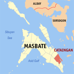 Map of Masbate with Cataingan highlighted | |
.svg.png) Cataingan Location within the Philippines | |
| Coordinates: 12°00′N 123°59′E / 12.000°N 123.983°ECoordinates: 12°00′N 123°59′E / 12.000°N 123.983°E | |
| Country | Philippines |
| Region | Bicol (Region V) |
| Province | Masbate |
| District | 3rd district |
| Barangays | 36 |
| Government[1] | |
| • Mayor | Wilton T. Kho |
| Area[2] | |
| • Total | 191.64 km2 (73.99 sq mi) |
| Population (2010)[3] | |
| • Total | 49,078 |
| • Density | 260/km2 (660/sq mi) |
| Time zone | PST (UTC+8) |
| Zip Code | 5405 |
| Dialing code | 56 |
Cataingan is a second class municipality in the province of Masbate, Philippines, about 77 kilometres (48 mi) southeast of Masbate City. According to the 2010 census, it has a population of 49,078 people.[3] Cataingan is one of the municipalities and cities of Masbate where Masbateño is the indigenous language.
In 1948, Placer, then a barrio of this town, was separated as a town by virtue of Republic Act No. 292, passed June 16, 1948.[4] Three years later, in 1951, the barrios of Limbuhan, Guindawahan, Palho, Casabangan, Salvacion, Alegria, Tanke, Bundukan, Bugtong, and Cabangrayan were separated from Cataingan and created into the town of Limbuhan.[5]
Barangays
Cataingan is politically subdivided into 36 barangays.[2]
- Abaca
- Aguada
- Badiang
- Bagumbayan
- Cadulawan
- Cagbatang
- Chimenea
- Concepcion
- Curvada
- Divisoria
- Domorog
- Estampar
- Gahit
- Libtong
- Liong
- Maanahao
- Madamba
- Malobago
- Matayum
- Matubinao
- Mintac
- Nadawisan
- Osmeña
- Pawican
- Pitogo
- Poblacion
- Quezon
- San Isidro
- San Jose
- San Pedro
- San Rafael
- Santa Teresita
- Santo Niño
- Tagboan
- Tuybo
- Villa Pogado
Demographics
| Population census of Cataingan | ||
|---|---|---|
| Year | Pop. | ±% p.a. |
| 1990 | 39,496 | — |
| 1995 | 42,065 | +1.19% |
| 2000 | 46,593 | +2.22% |
| 2007 | 48,827 | +0.65% |
| 2010 | 49,078 | +0.19% |
| Source: National Statistics Office[3][6] | ||
References
- ↑ "Municipalities". Quezon City, Philippines: Department of the Interior and Local Government. Archived from the original on 25 January 2013. Retrieved 24 January 2013.
- 1 2 "Province: Masbate". PSGC Interactive. Makati City, Philippines: National Statistical Coordination Board. Archived from the original on 14 November 2012. Retrieved 24 January 2013.
- 1 2 3 "Total Population by Province, City, Municipality and Barangay: as of May 1, 2010" (PDF). 2010 Census of Population and Housing. National Statistics Office. Archived from the original (PDF) on 19 November 2012. Retrieved 20 January 2013.
- ↑ "An act creating the municipality of Placer in the province of Masbate". LawPH.com. Retrieved 2011-04-09.
- ↑ "An Act Creating the Municipality of Limbuhan in the Province of Masbate". LawPH.com. Retrieved 2011-04-09.
- ↑ "Province of Masbate". Municipality Population Data. LWUA Research Division. Retrieved 23 July 2013.
External links
- Informations about Cataingan
- Philippine Standard Geographic Code
- Philippine Census Information
- Local Governance Performance Management System
- abante-cataingan.tripod.com
- elgu2.ncc.gov.ph
 |
Palanas | |
Samar Sea | |
| |
Samar Sea / Tagapul-an, Samar | |||
| ||||
| | ||||
| Placer | |
Pio V. Corpuz |
Masbate City (capital) | |
| Municipalities | |
| Component city | |
This article is issued from Wikipedia - version of the 11/17/2016. The text is available under the Creative Commons Attribution/Share Alike but additional terms may apply for the media files.