Tiwi, Albay
| Tiwi | |
|---|---|
| Municipality | |
|
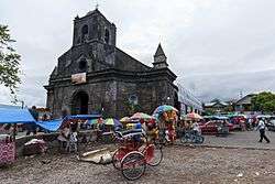
Tiwi church | |
 Location within Albay province | |
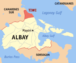
.svg.png) Tiwi Location within the Philippines | |
| Coordinates: 13°27′N 123°41′E / 13.45°N 123.68°ECoordinates: 13°27′N 123°41′E / 13.45°N 123.68°E | |
| Country | Philippines |
| Region | Bicol Region (Region V) |
| Province | Albay |
| District | 1st district |
| Founded | 1696 |
| Barangays | 25 (see Barangays) |
| Government [1] | |
| • Type | Sangguniang Bayan |
| • Mayor | Jaime Villanueva |
| Area[2] | |
| • Total | 105.76 km2 (40.83 sq mi) |
| Population (2015 census)[3] | |
| • Total | 53,120 |
| • Density | 500/km2 (1,300/sq mi) |
| • Voter (2016)[4] | 30,739 |
| Time zone | PST (UTC+8) |
| ZIP code | 4513 |
| IDD : area code | +63 (0)52 |
| Income class | 1st class |
| PSGC | 050518000 |
| Website |
www |
Tiwi, officially the Municipality of Tiwi (Filipino: Bayan ng Tiwi), is a municipality in the province of Albay in the Bicol Region (Region V) of the Philippines. The population was 53,120 at the 2015 census.[3] In the 2016 election, it had 30,739 registered voters.[4]
The present mayor is Hon. Leo P. Templado, serving in his first term after having won the mayoral election in May 2013.
History
Friars called the place Tigbi, which evolved into Tivi and, then, finally to its present name Tiwi.[5][6]
Tiwi began as a barrio of Malinao before it was formally organized as a politically independent pueblo in 1696. As a pueblo, it was governed by a gobernadorcillo. As a Catholic parish, it was administered by a secular priest under the then Diocese of Nueva Caceres, now an archdiocese. In its primeval stages, it had some 1,105 houses, a parish church, a community-funded primary school, and a cemetery outside the town proper. The villagers ordinarily engaged in fishing, planting rice, corn, sugarcane, indigo, fruit-bearing trees, and vegetables. Aside from agriculture, they also busied themselves weaving cotton and abaca clothes, and in pottery.[7]
In Kagnipa, known today as Barangay Baybay, the dilapidated Sinimbahan, the remnant of the first concrete house of worship built by the Franciscans led by the pastor of Malinao, Fray Pedro de Brosas, remains to be the deaf witness of both the villagers' ready acceptance of the Christian faith and their suffering of persecution at the hands of the Moslems; Christian missionaries called them Moros. The parola by the shore of Sitio Nipa of the same barangay testifies to the people's paralyzing fear of the Moros' capricious forays. The market site of the pueblo before these raids was located in the present location of Baybay Elementary School. In order to sidetrack surprise attacks, at least temporarily, the market site was transferred to southernmost part of now Brgy. Baybay; henceforth, it was called Binanwaan. The transfer, however, was useless. Finally, to have enough time to escape and keep themselves safer from their enemies' easy attacks, they moved the market site and their settlement to the present poblacion now named as Barangay Tigbi. Before the Moro's assaults, Brgy. Baybay was then the center of trade and commerce because of its easy accessibility to marine transportation of goods from the islands of what are now known as Catanduanes, San Miguel, Rapu-Rapu, and Batan, not to mention those from adjoining pueblos in the mainland of Ibalon, now the province of Albay, and the Camarines.[7]
In the extant records of the municipality, the first chief executive of the municipal government was Don Lorenzo Mancilla installed in 1776.
Geography
Tiwi is located at 13°27′N 123°41′E / 13.45°N 123.68°E.
According to the Philippine Statistics Authority, the municipality has a land area of 105.76 square kilometres (40.83 sq mi)[2] constituting 4.11% of the 2,575.77-square-kilometre- (994.51 sq mi) total area of Albay.
Barangays
Tiwi is politically subdivided into 25 barangays.[8]
| PSGC | Barangay | Population | ±% p.a. | ||
|---|---|---|---|---|---|
| 2015[3] | 2010[9] | ||||
| 050518001 | Bagumbayan | 4.4% | 2,315 | 2,148 | +1.44% |
| 050518002 | Bariis | 2.1% | 1,092 | 921 | +3.30% |
| 050518003 | Baybay | 4.3% | 2,265 | 2,207 | +0.50% |
| 050518004 | Belen (Malabog) | 2.6% | 1,406 | 1,273 | +1.91% |
| 050518005 | Biyong | 3.2% | 1,680 | 1,543 | +1.63% |
| 050518006 | Bolo | 2.3% | 1,205 | 1,173 | +0.51% |
| 050518007 | Cale | 10.5% | 5,557 | 5,245 | +1.11% |
| 050518008 | Cararayan | 3.8% | 2,012 | 2,011 | +0.01% |
| 050518009 | Coro-coro | 3.3% | 1,747 | 1,587 | +1.85% |
| 050518010 | Dap-dap | 1.7% | 891 | 765 | +2.95% |
| 050518011 | Gajo | 2.9% | 1,536 | 1,489 | +0.59% |
| 050518012 | Joroan | 5.2% | 2,741 | 2,667 | +0.52% |
| 050518013 | Libjo | 5.5% | 2,936 | 2,624 | +2.16% |
| 050518014 | Libtong | 4.3% | 2,304 | 2,253 | +0.43% |
| 050518017 | Matalibong | 2.6% | 1,397 | 1,290 | +1.53% |
| 050518018 | Maynonong | 1.6% | 824 | 674 | +3.90% |
| 050518019 | Mayong | 3.1% | 1,632 | 1,660 | −0.32% |
| 050518020 | Misibis | 4.1% | 2,192 | 2,064 | +1.15% |
| 050518021 | Naga | 8.7% | 4,629 | 4,614 | +0.06% |
| 050518023 | Nagas | 6.0% | 3,206 | 2,925 | +1.76% |
| 050518024 | Oyama | 2.4% | 1,289 | 1,208 | +1.24% |
| 050518025 | Putsan | 2.3% | 1,234 | 1,186 | +0.76% |
| 050518026 | San Bernardo | 3.3% | 1,759 | 1,530 | +2.69% |
| 050518027 | Sogod | 4.0% | 2,103 | 1,993 | +1.03% |
| 050518028 | Tigbi (Poblacion) | 6.0% | 3,168 | 3,113 | +0.33% |
| Total | 53,120 | 50,163 | +1.10% | ||
Demographics
| Population census of Tiwi | |||||||||||||||||||||||||
|---|---|---|---|---|---|---|---|---|---|---|---|---|---|---|---|---|---|---|---|---|---|---|---|---|---|
|
| ||||||||||||||||||||||||
| Source: PSA[3][9][10] | |||||||||||||||||||||||||
In the 2015 census, Tiwi had a population of 53,120.[3] The population density was 500 inhabitants per square kilometre (1,300/sq mi).
In the 2016 election, it had 30,739 registered voters.[4]
Attractions
- Parish Church of Our Lady of Salvation, Brgy. Joroan
- Parish Church of St. Lawrence, Deacon & Martyr, Brgy. Tigbi
- Corangon Shoal, Brgy. Baybay
- PhilCeramics, Brgy. Putsan
- Naglagbong Park cum Science Centrum Museum, Brgy. Cararayan
- Rangasa Spring Resort
- Sinimbahan Ruins, Brgy. Baybay
- Japanese Garden, Brgy. Tigbi
- Bugsukan Falls, Brgy. Misibis
- Baybay-Bolo Beach
- Sogod Beach
- Maslog Waterfalls, Brgy. Misibis
- Tiwi Geothermal Plants
- DJC Halo-Halo
- Capantagan Waterfalls, Brgy. Cale
References
- ↑ "Municipality". Quezon City, Philippines: Department of the Interior and Local Government. Retrieved 31 May 2013.
- 1 2 "Province: Albay". PSGC Interactive. Makati City, Philippines: Philippine Statistics Authority. Retrieved 29 October 2016.
- 1 2 3 4 5 "Region V (BICOL REGION)". Census of Population (2015): Total Population by Province, City, Municipality and Barangay (Report). PSA. Retrieved 20 June 2016.
- 1 2 3 "2016 National and Local Elections Statistics". Commission on Elections. 2016.
- ↑ The evolution of the nomenclature is not conclusive because a plant known as Tiwi (Bicol; Tua or Tui in Tagalog) also exists aside from the fact that the present poblacion was named differently being called Brgy. Tigbi; otherwise, it would have been simply called "poblacion".
- ↑
- 1 2 Natanauan, Rommel A. (December 2002), "Tiwi: Yesterday...Today...Tomorrow", 1st Tiwi Coron Festival Souvenir Magazine, pp. 17–19. Print
- ↑ "Municipal: Tiwi, Albay". PSGC Interactive. Quezon City, Philippines: Philippine Statistics Authority. Retrieved 8 January 2016.
- 1 2 "Region V (BICOL REGION)". Census of Population and Housing (2010): Total Population by Province, City, Municipality and Barangay (Report). NSO. Retrieved 29 June 2016.
- ↑ "Region V (BICOL REGION)". Census of Population (1995, 2000 and 2007): Total Population by Province, City and Municipality (Report). NSO. Archived from the original on 24 June 2011.
External links
| Wikimedia Commons has media related to Tiwi, Albay. |
 |
Sagñay, Camarines Sur | | ||
| Buhi, Camarines Sur | |
Lagonoy Gulf | ||
| ||||
| | ||||
| Malinao |
Legazpi (capital) | |
| Municipalities | |
| Component cities | |