Malinao, Albay
| Malinao | |
|---|---|
| Municipality | |
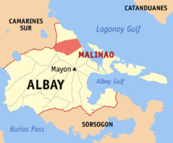 Location within Albay province | |
.svg.png) Malinao Location within the Philippines | |
| Coordinates: 13°24′N 123°42′E / 13.4°N 123.7°ECoordinates: 13°24′N 123°42′E / 13.4°N 123.7°E | |
| Country | Philippines |
| Region | Bicol Region (Region V) |
| Province | Albay |
| District | 1st district |
| Barangays | 29 (see Barangays) |
| Government [1] | |
| • Type | Sangguniang Bayan |
| • Mayor | Avelino Ceriola |
| Area[2] | |
| • Total | 107.5 km2 (41.5 sq mi) |
| Population (2015 census)[3] | |
| • Total | 45,301 |
| • Density | 420/km2 (1,100/sq mi) |
| • Voter (2016)[4] | 28,843 |
| Time zone | PST (UTC+8) |
| ZIP code | 4514 |
| IDD : area code | +63 (0)52 |
| Income class | 3rd class |
| PSGC | 050510000 |
| Website |
www |
Malinao, officially the Municipality of Malinao (Filipino: Bayan ng Malinao), is a municipality in the province of Albay in the Bicol Region (Region V) of the Philippines. The population was 45,301 at the 2015 census.[3] In the 2016 election, it had 28,843 registered voters.[4]
History
Malinao was founded in 1600, or 79 years after Ferdinand Magellan landed in Cebu and planted the first Christian Cross.
Between 1600 and 1616, Malinao was then part of the Diocese of Cagsawa (now Daraga). It became an independent bisita or sitio attached to Sawangan (now Legazpi City) until 1619, when separate religious administration was exercised with Rev. Francisco de Santa Ana, OFM, as first pastor.
Local folklore speaks of a plant once rich in this town called "alinao." The prefix "ma," which denotes abundance of something in local dialect, was affixed by the natives in referring to the place abundant with Alinao, thus Ma-alinao and later corrupted to Malinao.
It was, however, in 1916 when, according to legendary account, Malinao got its name. A siege by Moros on town resulted in the abduction of seven women. Miraculously, the boat sank within the jurisdictional waters of Malinao and on that same spot in the sea across the island of natunawan because of the women's fervent prayer in canticles and "tarahades" or clear thoughts for the Blessed Virgin to sink the boat. From these "clear thoughts" of the seven women translated in Bicol dialect as "malinao na isip." The name of Malinao was given to the Municipality. It has since then the tradition among the residents particularly the women, to sing the canticles or tarahades in times of crisis or calamities or when they want to drive away epidemics and misfortunes.
Geography
Malinao is located at 13°24′N 123°42′E / 13.4°N 123.7°E.
According to the Philippine Statistics Authority, the municipality has a land area of 107.5 square kilometres (41.5 sq mi)[2] constituting 4.17% of the 2,575.77-square-kilometre- (994.51 sq mi) total area of Albay.
Malinao occupies a narrow stretch of plains hemmed in by the Lagonoy Gulf in the east and Mount Malinao on the west. The area is dominated by the mountain ranges of Malinao, with a peak altitude of 1,584 metres (5,197 ft) above sea level.
The town is 587 kilometres (365 mi) south-east of Manila, 32 kilometres (20 mi) north of Albay Provincial Capitol, and 5 kilometres (3.1 mi) north of Tabaco City.
Land use
- Public Land: 72.60 hectares (179.4 acres)
- Built-up/Residential: 985.76 hectares (2,435.9 acres)
- Agricultural: 5,750.34 hectares (14,209.4 acres)
- Irrigable: 2,250 hectares (5,600 acres)
- Irrigated: 1,873 hectares (4,630 acres)
- Forest: 1,569.30 hectares (3,877.8 acres)
- Timberland: 21.00 hectares (51.9 acres)
- 2nd growth: 615.00 hectares (1,519.7 acres)
- Watershed: 870.00 hectares (2,149.8 acres)
- Mangrove/swamp: 63.30 hectares (156.4 acres)
- Grassland/Shrub/Pasture: 15.00 hectares (37.1 acres)
- Idle/Vacant Lot: 49.00 hectares (121.1 acres)
- Nipas: 2,308.00 hectares (5,703.2 acres)
Barangays
Malinao is politically subdivided into 29 barangays.[5] Of these, 12 are upland barangays, 13 lowland barangays, and 4 are coastal barangays. Twenty-five barangays are rural areas and the remaining four are urban.
| PSGC | Barangay | Population | ±% p.a. | ||
|---|---|---|---|---|---|
| 2015[3] | 2010[6] | ||||
| 050510001 | Awang | 0.8% | 347 | 336 | +0.62% |
| 050510002 | Bagatangki | 1.7% | 772 | 569 | +5.98% |
| 050510022 | Bagumbayan | 1.7% | 788 | 699 | +2.31% |
| 050510003 | Balading | 6.9% | 3,104 | 2,996 | +0.68% |
| 050510004 | Balza | 4.6% | 2,084 | 2,061 | +0.21% |
| 050510005 | Bariw | 3.4% | 1,524 | 1,353 | +2.29% |
| 050510006 | Baybay | 3.8% | 1,730 | 1,647 | +0.94% |
| 050510007 | Bulang | 2.3% | 1,028 | 864 | +3.36% |
| 050510008 | Burabod | 1.8% | 837 | 836 | +0.02% |
| 050510009 | Cabunturan | 1.3% | 577 | 681 | −3.11% |
| 050510010 | Comun | 3.9% | 1,772 | 1,672 | +1.11% |
| 050510011 | Diaro | 2.0% | 889 | 885 | +0.09% |
| 050510012 | Estancia | 9.5% | 4,293 | 3,987 | +1.42% |
| 050510013 | Jonop | 4.5% | 2,024 | 2,009 | +0.14% |
| 050510014 | Labnig | 7.7% | 3,479 | 3,410 | +0.38% |
| 050510015 | Libod | 2.4% | 1,065 | 949 | +2.22% |
| 050510016 | Malolos | 1.9% | 856 | 785 | +1.66% |
| 050510017 | Matalipni | 4.3% | 1,939 | 1,863 | +0.76% |
| 050510018 | Ogob | 4.4% | 1,992 | 1,975 | +0.16% |
| 050510019 | Pawa | 2.7% | 1,217 | 1,103 | +1.89% |
| 050510020 | Payahan | 3.1% | 1,414 | 1,390 | +0.33% |
| 050510021 | Poblacion | 1.5% | 657 | 570 | +2.74% |
| 050510023 | Quinarabasahan | 1.8% | 821 | 735 | +2.13% |
| 050510024 | Santa Elena | 2.5% | 1,133 | 1,018 | +2.06% |
| 050510025 | Soa | 3.0% | 1,352 | 1,248 | +1.54% |
| 050510026 | Sugcad | 3.9% | 1,784 | 1,615 | +1.91% |
| 050510027 | Tagoytoy | 5.1% | 2,323 | 2,217 | +0.89% |
| 050510028 | Tanawan | 3.8% | 1,739 | 1,638 | +1.15% |
| 050510029 | Tuliw | 3.9% | 1,761 | 1,659 | +1.14% |
| Total | 45,301 | 42,770 | +1.10% | ||
Demographics
| Population census of Malinao | ||
|---|---|---|
| Year | Pop. | ±% p.a. |
| 1990 | 31,349 | — |
| 1995 | 33,872 | +1.46% |
| 2000 | 36,231 | +1.45% |
| 2007 | 39,516 | +1.20% |
| 2010 | 42,770 | +2.92% |
| 2015 | 45,301 | +1.10% |
| Source: PSA[3][6][7] | ||
In the 2015 census, Malinao had a population of 45,301.[3] The population density was 420 inhabitants per square kilometre (1,100/sq mi).
In the 2016 election, it had 28,843 registered voters.[4]
In 1995, The total population was 33,872, which increased by 2359 individuals or 6.94% for five (5) years in 2000. In the 2010 census, the population had reached 42,770.
Of these, less than ten (10) per cent or 3,301 reside in the urban barangays of Bagumbayan, Pawa, Payahan and Poblacion. The rest of the constituents meanwhile stay on the rural barangays: Awang, Bagatangki, Balading, Balza, Bariw, Baybay, Bulang, Burabod, Cabunturan, Comun, Diaro, Estancia, Jonop, Labnig, Libod, Malolos, matalipni, Ogob, Quinarabasahan, Santa Elena, Soa, Sugcad, Tagoytoy, Tanawan and Tuliw. The densest areas are Estancia, Labnig and Balading while Awang and Bagatangki are the least populated in the rural areas.
Majority of its population engages in agriculture and other agri-related enterprise.
Economy
|
The major agricultural products are:
|
Other crops:
|
References
- ↑ "Municipality". Quezon City, Philippines: Department of the Interior and Local Government. Retrieved 31 May 2013.
- 1 2 "Province: Albay". PSGC Interactive. Makati City, Philippines: Philippine Statistics Authority. Retrieved 28 October 2016.
- 1 2 3 4 5 "Region V (BICOL REGION)". Census of Population (2015): Total Population by Province, City, Municipality and Barangay (Report). PSA. Retrieved 20 June 2016.
- 1 2 3 "2016 National and Local Elections Statistics". Commission on Elections. 2016.
- ↑ "Municipal: Malinao, Albay". PSGC Interactive. Quezon City, Philippines: Philippine Statistics Authority. Retrieved 8 January 2016.
- 1 2 "Region V (BICOL REGION)". Census of Population and Housing (2010): Total Population by Province, City, Municipality and Barangay (Report). NSO. Retrieved 29 June 2016.
- ↑ "Region V (BICOL REGION)". Census of Population (1995, 2000 and 2007): Total Population by Province, City and Municipality (Report). NSO. Archived from the original on 24 June 2011.
 |
Buhi, Camarines Sur | Tiwi | | |
| Polangui | |
Lagonoy Gulf | ||
| ||||
| | ||||
| Tabaco |
Legazpi (capital) | |
| Municipalities | |
| Component cities | |