Camaligan, Camarines Sur
| Camaligan | |
|---|---|
| Municipality | |
| Municipality of Camaligan | |
 | |
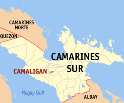 Map of Camarines Sur showing the location of Camaligan | |
.svg.png) Camaligan Location within the Philippines | |
| Coordinates: 13°37′30″N 123°09′25″E / 13.625°N 123.1569°ECoordinates: 13°37′30″N 123°09′25″E / 13.625°N 123.1569°E | |
| Country | Philippines |
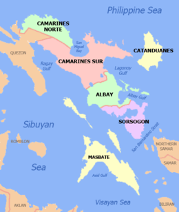
| Region | Bicol (Region V) |
| Province | Camarines Sur |
| District | 3rd district |
| Barangays | 13 |
| Government[1] | |
| • Type | Municipality |
| • Mayor | Marilou Marquez-Hirose |
| Area[2] | |
| • Total | 4.68 km2 (1.81 sq mi) |
| Population (2015 census)[3] | |
| • Total | 24,109 |
| • Density | 5,200/km2 (13,000/sq mi) |
| Time zone | PST (UTC+8) |
| ZIP code | 4401 |
| IDD : area code | +63 (0)54 |
| Income Class | 5th Class |
Camaligan is a fifth class municipality in the province of Camarines Sur, Philippines. According to the 2015 census, it has a population of 24,109 people.[3]
With an area of 468.8 hectares (1,158 acres), it is the smallest municipality in Camarines Sur, but it is the densest, having 4755 persons per square kilometer, which is almost twice the density of the Naga City.
Barangays
Camaligan is politically subdivided into 13 barangays.[2]
- Gogon-Dugcal
- Marupit
- San Francisco
- San Jose-San Pablo (Poblacion)
- San Juan-San Ramon (Poblacion)
- San Lucas (Poblacion)
- San Mateo (Poblacion)
- San Marcos (Poblacion)
- San Roque
- Santo Domingo (Poblacion)
- Santo Tomas (Poblacion)
- Sua-Tampac
- Tarosanan
History
The origin of the town and its name can be traced back to the early settlers of the place. Known as the “Canoadores” (Certadores) to the early Spanish colonizers who came to the place in the early Seventeenth Century (17th), the settlers cut timbers from nearby mountains located upriver or around San Miguel bay area and made this as their form of living. Out of these timbers they hewed out canoes or “bancas” which they stored under small sheds or huts. Later, when these sheds became abundant in the area, as they were made the permanent dwelling places by these canoe makers, the place was called “CAMALIGAN” from the word “KAMALIG” or shed, a place where so many “Kamalig” are found. The sheds served to shelter the canoe makers and protect their boats from the natural elements. Hence, the name and origin of the town is historically tied to the river and its early inhabitants.
The original settlement was considered a religious visita of Nueva Caceres, which was then under its ecclesiastical jurisdiction. On the 5th of June 1775, a petition to the Spanish religious authorities was sent by the natives and signed by the supposedly officials of the place, to request for a resident curate. The officials’ names were: Andre Casa, Diego, Lobao, Simeon de la Cruz, Manuel del Espiritu Santo, Fernando Valenzuela, Agustin del Espiritu Santo, Marcos David, Domingo Flores, Pedro Negre, Bartolome Rodriguez and Valentine de los Santos.
The official establishment of the municipality is in year 1902 through an act of the Philippine legislature. It also named Pedro Bustamante as the first (1st) Municipal Mayor. This event of the creation of the Municipality of Camaligan was brought about by a historical fact when Camaligan was eventually separated from being as annex town to Nueva Caceres now Naga City.
The people of Camaligan derived their socio-cultural identity as river people from the existence of the river. Bicol River is an important resource for irrigation and fertilization of the land where agriculture and fishing is still considered as a major industry. The place’s festivals, songs and dances found their roots and inspiration from the river. Hence, it could be said that the river ecology has bred its own distinct community.
Demographics
| Population census of Camaligan | ||
|---|---|---|
| Year | Pop. | ±% p.a. |
| 1990 | 15,436 | — |
| 1995 | 17,411 | +2.28% |
| 2000 | 19,188 | +2.11% |
| 2007 | 20,758 | +1.09% |
| 2010 | 22,254 | +2.56% |
| 2015 | 24,109 | +1.54% |
| Source: Philippine Statistics Authority[3][4][5] | ||
In the 2015 census, the population of Camaligan was 24,109 people,[3] with a density of 5,200 inhabitants per square kilometre or 13,000 inhabitants per square mile.
Educational institutions
- Camaligan National High School
- Camaligan Central School
- Sua Elementary School
- Dugcal Elementary School
- San Roque Elementary School
- Marupit Elementary School
- San Francisco-Tarosanan Elementary School
- San Mateo Day Care Center
- San Marcos Day Care Center
- San Ramon Day Care Center
Festivals
- Kamalig Festival
- Kamaligang Pasko Festival
References
- ↑ "Municipalities". Quezon City, Philippines: Department of the Interior and Local Government. Archived from the original on 25 January 2013. Retrieved 3 January 2013.
- 1 2 "Province: CAMARINES SUR". PSGC Interactive. Makati City, Philippines: National Statistical Coordination Board. Retrieved 3 January 2013.
- 1 2 3 4 "Region V (BICOL REGION)". Census of Population (2015): Total Population by Province, City, Municipality and Barangay (Report). PSA. Retrieved 20 June 2016.
- ↑ "Region V (BICOL REGION)". Census of Population and Housing (2010): Total Population by Province, City, Municipality and Barangay (Report). NSO. Retrieved 29 June 2016.
- ↑ "Province of Camarines Sur". Municipality Population Data. LWUA Research Division. Retrieved 24 July 2013.
External links
| Wikimedia Commons has media related to Camaligan, Camarines Sur. |
- Philippine Standard Geographic Code
- Philippine Census Information
- Official Site of the Province of Camarines Sur
 |
Canaman | | ||
| Pamplona | |
Naga City | ||
| ||||
| | ||||
| Gainza | Milaor |
Pili (capital) | |
| Municipalities | |
| Component city | |
| Independent component city |
|
| Administrative Divisions |
|  | ||||||
|---|---|---|---|---|---|---|---|---|
| Geography | ||||||||
| History | ||||||||
| Religion | ||||||||
| Public Utilities and Services |
| |||||||
| Transportation | ||||||||
| Education | ||||||||
| Landmarks |
| |||||||