The Plains, Virginia
| The Plains, Virginia | |
|---|---|
| Town | |
|
Carter Hotel on the west end of town | |
 Location of The Plains, Virginia | |
| Coordinates: 38°51′46″N 77°46′32″W / 38.86278°N 77.77556°WCoordinates: 38°51′46″N 77°46′32″W / 38.86278°N 77.77556°W | |
| Country | United States |
| State | Virginia |
| County | Fauquier |
| Area | |
| • Total | 0.3 sq mi (0.7 km2) |
| • Land | 0.3 sq mi (0.7 km2) |
| • Water | 0.0 sq mi (0.0 km2) |
| Elevation | 610 ft (186 m) |
| Population (2010) | |
| • Total | 217 |
| • Density | 819/sq mi (316.4/km2) |
| Time zone | Eastern (EST) (UTC-5) |
| • Summer (DST) | EDT (UTC-4) |
| ZIP code | 20198 |
| Area code(s) | 540 |
| FIPS code | 51-78192[1] |
| GNIS feature ID | 1496309[2] |
| Website |
www |
The Plains is a town in Fauquier County, Virginia, United States. The population was 217 at the 2010 census,[3] down from 266 at the 2000 census. It is centered on the intersection of Virginia Route 55 (John Marshall Highway) and Virginia Route 245 (Old Tavern Road). The mayor of The Plains is Robert Gurtler.
Geography
The Plains is located in northeastern Fauquier County at 38°51′46″N 77°46′32″W / 38.86278°N 77.77556°W (38.862698, -77.775464).[4] VA 55 leads southeast 10 miles (16 km) to Gainesville and west 4.5 miles (7.2 km) to Marshall. VA 245 leads southwest 1 mile (1.6 km) to Interstate 66 at Exit 31. I-66 leads east 45 miles (72 km) to Washington, D.C. and west 24 miles (39 km) to Front Royal.
According to the United States Census Bureau, the town has a total area of 0.3 square miles (0.7 km2), all of it land.[3]
Demographics
| Historical population | |||
|---|---|---|---|
| Census | Pop. | %± | |
| 1920 | 275 | — | |
| 1930 | 414 | 50.5% | |
| 1940 | 372 | −10.1% | |
| 1950 | 405 | 8.9% | |
| 1960 | 484 | 19.5% | |
| 1970 | 418 | −13.6% | |
| 1980 | 382 | −8.6% | |
| 1990 | 219 | −42.7% | |
| 2000 | 266 | 21.5% | |
| 2010 | 217 | −18.4% | |
| Est. 2015 | 226 | [5] | 4.1% |
As of the census[1] of 2000, there were 266 people, 110 households, and 70 families residing in the town. The population density was 1,035.1 people per square mile (395.0/km²). There were 118 housing units at an average density of 459.2 per square mile (175.2/km²). The racial makeup of the town was 89.85% White and 10.15% African American. Hispanic or Latino of any race were 0.38% of the population.
There were 110 households out of which 25.5% had children under the age of 18 living with them, 44.5% were married couples living together, 14.5% had a female householder with no husband present, and 35.5% were non-families. 31.8% of all households were made up of individuals and 10.9% had someone living alone who was 65 years of age or older. The average household size was 2.42 and the average family size was 3.01.
In the town the population was spread out with 21.1% under the age of 18, 5.6% from 18 to 24, 32.0% from 25 to 44, 26.3% from 45 to 64, and 15.0% who were 65 years of age or older. The median age was 42 years. For every 100 females there were 91.4 males. For every 100 females age 18 and over, there were 85.8 males.
The median income for a household in the town was $43,750, and the median income for a family was $45,313. Males had a median income of $41,250 versus $33,542 for females. The per capita income for the town was $27,909. About 13.7% of families and 14.1% of the population were below the poverty line, including 11.1% of those under the age of eighteen and 14.8% of those sixty five or over.
Churches
-

St. Mark's United Methodist Church
-

Grace Episcopal Church
-

First Baptist Church
-

The Plains Baptist Church
Attractions
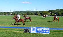
The Plains is home to Great Meadow, a large open-air and open-field facility that hosts several large events throughout the year, including the Virginia Gold Cup steeplechase horse race, which attracts over 50,000 guests on the first Saturday of each May.[7]
Archwood Green Barns Farmer's Market features fresh, home made and local products. Hours are Sunday, 10:00 a.m. to 3:00 p.m. beginning the last Sunday in April through the 2nd Sunday in November. It is open the first two Sundays in December for the "Christmas on the Farm" show.
A museum exhibit, "Footprint to Change", is located at 4243 Loudoun Avenue near the train tracks that go through town. The building houses the Afro-American Historical Association of Fauquier County offices, library and archives as well as the museum.[8]
Long Branch Baptist Church (est. 1786), the third oldest Baptist church in Virginia, lies 4 miles (6 km) north of The Plains in the unincorporated area called Halfway. The evangelist William Broaddus, founder of Southwestern Seminary in Louisville, Kentucky, was pastor there in the 1830s. His nephew John Broadus is often called "the father of homiletics" (preaching).
Wakefield School, a pre-school through Grade 12 independent school, is located just south of the town limits.
Actor Robert Duvall once owned a restaurant in The Plains called "The Rail Stop". He still makes his residence north of town at his 360-acre (1.5 km2) Brindley Farm.
The town is also home to a seasonal corn maze owned and operated by locals.
The National Association of Rocketry held NARAM-50 there in the summer of 2008.
The Masonic lodge was organized on a site near the present post office. The Plains Lodge U.D. held its first meeting on December 29, 1898, and continued to work "Under Dispensation" until the Grand Lodge of Virginia met in Alexandria on December 15, 1899, and issued the lodge a charter under the name of Cochran Lodge No. 271.
Beverley Mill was listed on the National Register of Historic Places in 1972,[9] and most of the town was listed as The Plains Historic District in 2014.[10][11]
Climate
The climate in this area is characterized by hot, humid summers and generally mild to cool winters. According to the Köppen Climate Classification system, The Plains has a humid subtropical climate, abbreviated "Cfa" on climate maps.[12]
Other photos
-

Carter Hotel next to RR tracks
-

Old High School at west end of town
-

Train depot - brick
-
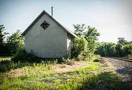
Train depot - frame
-

Former jail
See also
References
- 1 2 "American FactFinder". United States Census Bureau. Retrieved 2008-01-31.
- ↑ "US Board on Geographic Names". United States Geological Survey. 2007-10-25. Retrieved 2008-01-31.
- 1 2 "Geographic Identifiers: 2010 Demographic Profile Data (G001): The Plains town, Virginia". U.S. Census Bureau, American Factfinder. Retrieved October 18, 2016.
- ↑ "US Gazetteer files: 2010, 2000, and 1990". United States Census Bureau. 2011-02-12. Retrieved 2011-04-23.
- ↑ "Annual Estimates of the Resident Population for Incorporated Places: April 1, 2010 to July 1, 2015". Retrieved July 2, 2016.
- ↑ "Census of Population and Housing". Census.gov. Retrieved June 4, 2015.
- ↑ Ridgway-Khalifa, Daisy (March 21, 2012). "A Day in the Country". Virginia Living. Cape Fear Publishing. Retrieved June 27, 2016.
- ↑ "Virtual Museum". Footsteps to Change. Afro-American Historical Association of Fauquier County. Retrieved 20 November 2013.
- ↑ National Park Service (2010-07-09). "National Register Information System". National Register of Historic Places. National Park Service.
- ↑ "NRHP nomination for The Plains Historic District" (PDF). Virginia DHR. Retrieved 2014-06-06.
- ↑ "NRHP actions taken, 5/26/14 through 5/30/14". National Park Service. Retrieved 2014-06-06.
- ↑ Climate Summary for The Plains, Virginia
External links
- Town of The Plains official website
- virginia.org website
- Great Meadows
- Virginia Gold Cup
- Corn Maze in The Plains
- Fauquier County tourism website
- Cochran Lodge No. 271 A.F. & A.M.
Municipalities and communities of Fauquier County, Virginia, United States | ||
|---|---|---|
| Towns | 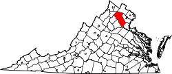 | |
| CDPs | ||
| Unincorporated communities | ||
| Footnotes | ‡This populated place also has portions in an adjacent county or counties | |

