Abingdon, Virginia
| Abingdon, Virginia | ||
|---|---|---|
| Town | ||
|
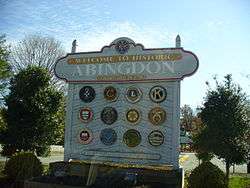
Abingdon Welcome Sign | ||
| ||
| Motto: Honor Pro Antiquis, Fides Pro Futuris | ||
 Location in the Commonwealth of Virginia | ||
| Coordinates: 36°42′35″N 81°58′32″W / 36.70972°N 81.97556°WCoordinates: 36°42′35″N 81°58′32″W / 36.70972°N 81.97556°W | ||
| Country | United States | |
| State | Virginia | |
| County | Washington | |
| Founded | 1778 | |
| Government | ||
| • Mayor | Edward Morgan | |
| Area | ||
| • Total | 8.3 sq mi (21.6 km2) | |
| • Land | 8.3 sq mi (21.6 km2) | |
| • Water | 0 sq mi (0 km2) | |
| Elevation | 2,087 ft (636 m) | |
| Population (2010) | ||
| • Total | 8,191 | |
| • Density | 932.6/sq mi (360.2/km2) | |
| Time zone | EST (UTC-5) | |
| • Summer (DST) | EDT (UTC-4) | |
| ZIP codes | 24210-24212 | |
| Area code(s) | 276 | |
| FIPS code | 51-00148[1] | |
| GNIS feature ID | 1498444[2] | |
| Website |
www | |

Abingdon is a town in Washington County, Virginia, United States, 133 miles (214 km) southwest of Roanoke. The population was 8,191 at the 2010 census. It is the county seat of Washington County[3] and is a designated Virginia Historic Landmark. The town encompasses several historically significant sites and features a fine arts and crafts scene centered on the galleries and museums along Main Street.
Abingdon is part of the Kingsport−Bristol (TN)−Bristol (VA) Metropolitan Statistical Area, which is a component of the Johnson City−Kingsport−Bristol, TN-VA Combined Statistical Area − commonly known as the "Tri-Cities" region.
History

The region was long the territory of varying cultures of indigenous peoples, including the Chisca and Xualae. From the late 17th-century, it was occupied by the Cherokee Nation, whose territory extended from the present-day area of borders of Tennessee, Virginia, and Kentucky through the spine of North Carolina and later into Georgia.
Between 1748 and 1750, Dr. Thomas Walker surveyed the land where the town of Abingdon is situated. It was on the Great Road that Colonel William Byrd III ordered cut through the wilderness on to Kingsport, Tennessee.[4] In 1760, the famed frontiersman Daniel Boone named the area Wolf Hills, after his dogs were attacked by a pack of wolves during a hunting expedition. The site of the attack is on 'Courthouse Hill'. In the twenty-first century, the town sponsored a public art event, in which artists created 27 wolf sculptures, which were installed around the town. Most were later sold at an auction to raise money for Advance Abingdon.[4]
Between the years 1765 and 1770 James Douglas, Andrew Colville, George Blackburn, Joseph Black, Samuel Briggs and James Piper settled in and around present-day Abingdon under purchases from Dr. Thomas Walker.
During Lord Dunmore's War, Joseph Black built Black's Fort in 1774 to protect local settlers in the region from attacks by the Cherokee of the Lower Towns.[4] It consisted of a log stockade, with a few log cabins inside, where nearby settlers took refuge in event of attack. They retreated to the fort in 1776 when attacked by the war leader Dragging Canoe and his Chickamauga Cherokee forces. Hoping to push out the colonists, the Cherokee had allied with the British in the American Revolutionary War.[5] The settlement was known as Black’s Fort prior to being named Abingdon. Black, Briggs and Walker donated the 120 acres of land upon which the original town was laid out.
It was at the intersection of two great Indian trails, which had followed ancient animal migration trails through the mountains. It was a prime location as a trade center and access point to the west and south. In 1776 the community of Black's Fort was made the county seat of the newly formed Washington county. In 1778, Black's Fort was incorporated as the town of Abingdon, said to be named for the ancestral home of Martha Washington in Oxfordshire, England.
Possible namesakes for the town include Jake Dore's home in Abington, Pennsylvania, or Lord Abingdon, friend of settler William Campbell.[6]
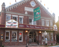
Martha Washington College, a school for women, operated in Abingdon from 1860 to 1932 in a former private residence. Since 1935 the building has been occupied and operated as a hotel, the Martha Washington Inn. The Barter Theatre, the state theatre of Virginia, was opened in Abingdon in 1933 during the Great Depression.
Abingdon is the final stop along the Virginia Creeper Trail, which allows pedestrian, cyclist and equestrian traffic. This trail is 35 miles long, extending from White Top Mountain through Damascus, Virginia, with the trailhead in Abingdon. The Historical Society of Washington County, Virginia, located in Abingdon, serves as a regional genealogy center, in addition to being a repository for Washington County history.
The Abingdon Historic District, Abingdon Bank, Mont Calm, Moonlite Theatre, Dr. William H. Pitts House, White's Mill, and Baker-St. John House are listed on the National Register of Historic Places.[7][8]
Climate
| Climate data for Abingdon, Virginia | |||||||||||||
|---|---|---|---|---|---|---|---|---|---|---|---|---|---|
| Month | Jan | Feb | Mar | Apr | May | Jun | Jul | Aug | Sep | Oct | Nov | Dec | Year |
| Average high °F (°C) | 44.2 (6.8) |
48.5 (9.2) |
58.3 (14.6) |
67.7 (19.8) |
75.1 (23.9) |
81.8 (27.7) |
84.7 (29.3) |
84.2 (29) |
78.6 (25.9) |
68.6 (20.3) |
58.1 (14.5) |
47.7 (8.7) |
66.5 (19.2) |
| Average low °F (°C) | 23.6 (−4.7) |
25.7 (−3.5) |
32.8 (0.4) |
40.1 (4.5) |
48.8 (9.3) |
57.0 (13.9) |
60.7 (15.9) |
59.9 (15.5) |
53.2 (11.8) |
41.4 (5.2) |
33.5 (0.8) |
26.4 (−3.1) |
41.9 (5.5) |
| Average precipitation inches (mm) | 4.0 (102) |
3.6 (91) |
4.3 (109) |
3.8 (97) |
4.6 (117) |
4.1 (104) |
4.9 (124) |
3.7 (94) |
3.4 (86) |
2.8 (71) |
3.3 (84) |
4.0 (102) |
46.4 (1,179) |
| Source: Weatherbase [9] | |||||||||||||
Geography
Abingdon is located at 36°42′35″N 81°58′32″W / 36.70972°N 81.97556°W (36.709773, −81.975694).[10]
According to the United States Census Bureau, the town has a total area of 8.3 square miles (21.6 km²), all land.
The town is located in the Great Appalachian Valley, between the Middle Fork and the North Fork of the Holston River.
Demographics
| Historical population | |||
|---|---|---|---|
| Census | Pop. | %± | |
| 1870 | 715 | — | |
| 1880 | 1,064 | 48.8% | |
| 1890 | 1,674 | 57.3% | |
| 1900 | 1,306 | −22.0% | |
| 1910 | 1,757 | 34.5% | |
| 1920 | 2,532 | 44.1% | |
| 1930 | 2,877 | 13.6% | |
| 1940 | 3,158 | 9.8% | |
| 1950 | 4,709 | 49.1% | |
| 1960 | 4,758 | 1.0% | |
| 1970 | 4,376 | −8.0% | |
| 1980 | 4,318 | −1.3% | |
| 1990 | 7,003 | 62.2% | |
| 2000 | 7,780 | 11.1% | |
| 2010 | 8,191 | 5.3% | |
| Est. 2015 | 8,119 | [11] | −0.9% |
| source:[12] | |||

As of the census[1] of 2010, there were 8,191 people, 3,878 households residing in the town. The population density was 932.6 people per square mile (360.2/km²). There were 3,788 housing units at an average density of 454.1 per square mile (175.4/km²). The racial makeup of the town was 93.8% White, 3.1% African American, 0.2% Native American, 1.0% Asian, 0.1% Pacific Islander, 0.8% from other races, and 1.0% from two or more races. Hispanic or Latino of any race were 2.6% of the population.[13]
There were 3,522 households out of which 23.3% had children under the age of 18 living with them, 45.6% were married couples living together, 10.6% had a female householder with no husband present, and 40.6% were non-families. 36.7% of all households were made up of individuals and 14.9% had someone living alone who was 65 years of age or older. The average household size was 2.08 and the average family size was 2.72.
In the town the population was spread out with 18.3% under the age of 18, 8.2% from 18 to 24, 27.4% from 25 to 44, 25.5% from 45 to 64, and 20.6% who were 65 years of age or older. The median age was 42 years. For every 100 females there were 81.0 males. For every 100 females age 18 and over, there were 77.6 males.
The median income for a household in the town was $30,976, and the median income for a family was $46,106. Males had a median income of $32,005 versus $22,844 for females. The per capita income for the town was $22,486. About 7.3% of families and 10.1% of the population were below the poverty line, including 10.4% of those under age 18 and 9.7% of those age 65 or over.
Education
Abingdon is served by Washington County Public Schools, in which students attend Abingdon Elementary, Watauga Elementary, Greendale Elementary, E.B. Stanley Middle School, and Abingdon High School.
Virginia Highlands Community College located in Abingdon is the local community college offering 2-year degrees.
Emory & Henry College is located 7 miles outside of town.
Southwest Virginia Higher Education Center, on the campus of VHCC, provides the region with access to undergraduate and graduate degree programs and courses. Participating academic institutions include: Emory & Henry College, Old Dominion University, Radford University, University of Virginia, University of Virginia's College at Wise, Virginia Commonwealth University, Virginia Highlands Community College, Virginia Intermont College, and Virginia Tech.
Economy
Alpha Natural Resources is not based in Abingdon any longer, but in nearby Bristol, VA .
Points of interest
- William King Museum of Art
- Abingdon Historic District, which includes the Fields-Penn House, Arts Depot, and the Martha Washington Inn.
- Barter Theatre, designated as the "State Theatre of Virginia" in 1946 and is one of the longest-running professional regional theatres in the nation. In 1940, Gregory Peck, before becoming a major star, worked in exchange for food and performed at the Barter Theatre, appearing in five plays including Family Portrait and On Earth as It Is.
- The northern end of the Overmountain Victory National Historic Trail lies in Abingdon at the Abingdon Munster Grounds[14]
- Virginia Creeper Trail, a 35-mile rail trail that runs from Abingdon to Whitetop, Virginia.
- The Virginia Highlands Festival, is a festival that was started in 1948 by Robert Porterfield, founder of the Barter Theatre, as a simple one-week festival to showcase Appalachian arts and crafts. The festival has now grown into a 16-day event offering a variety of venues. Every year hundreds of volunteers work to create new events for the festival for locals and tourists to enjoy.
- The Crooked Road- Virginia's Heritage Music Trail, Explores Virginia's mountain regions and the rich heritage of the mountain people, focusing on their traditional.
Notable people
Three Virginia governors lived here: Wyndham Robertson, David Campbell, and John B. Floyd.
- Robert Armstrong, (1792–1854), born in Abingdon, United States Army officer and candidate for Governor of Tennessee[15]
- Martin Beaty (1784–1856), born in Abingdon, United States Congressman from Kentucky [15]
- Francis Preston Blair, (1791–1876), born in Abingdon, journalist and politician [15]
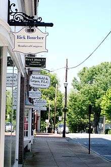
- Rick Boucher, (b. 1946), Abingdon native, U.S. Congressman for the 9th congressional District (map), served 13 terms (1983-2011).
- Scott Cooper (b. 1970), film director
- James King Gibson, (1812–1879), born in Abingdon, United States Congressman from Virginia [15]
- Gail Harris, (b. 1931), born in Abingdon, major league baseball player for New York Giants and Detroit Tigers[16][17]
- Henry Jackson (1811-1857), Minnesota pioneer[18]
- John W. Johnston, (1818–1889), nephew of Gen. Joseph E. Johnston, served as United States Senator after Virginia readmitted to the Union in 1869.
- Joseph E. Johnston, (1807–1891), lived in Abingdon as a boy, Confederate General in the American Civil War.
- Eric McClure (b. 1978), driver in the NASCAR Nationwide Series.
- William McMillan, (1764–1804), born in Abingdon, lawyer. district attorney, and United States Congressman from Ohio Territory.[15]
- Henry Warren Ogden (1842-1905), born in Abingdon, became a Louisiana planter and politician; Confederate States of America lieutenant and prisoner of war.
- Granville Henderson Oury, (1825–1885), born in Abingdon, captain in the Confederate Army and later United States Congressman from Arizona.[15]
- John S. Preston, (1809–1881), born in Abingdon, Confederate general in the American Civil War and South Carolina politician
- Robert Sheffey (1820–1902), grew up in Abingdon, eccentric Methodist circuit-rider and evangelist.
- Hiram Emory Widener, Jr., (1923–2007), born and died in Abingdon, judge of the United States Court of Appeals for the Fourth Circuit, and one of the longest-serving federal judges in United States history.
Mayors of Abingdon, Virginia
- John Montgomery Preston 1834-1836, 1842-1843
- J. M. Butt 1910-1912
- T.H. Crabtree 1912-1916, 1926-1930, 1936-1940.
- A.P. Hutton 1920-1922
- George F. Grant 1916-1920
- R.B. Hagy 1922-1926, 1931-1935
- E.W. Potts 1935-1936
- T.C. Phillips 1940-1946
- Ronald C. Craig 1946-1948
- John C. Summers, Jr. 1948-1950
- Charles Henry Butt 1950-1966
- J.A. Johnson 1966-1972
- George W. Summerson 1972-1978
- Harry L. Coomes 1978-1982
- French Moore, Jr.
- Joe Phipps
- Lois Humphries
- Ed Morgan 2010–2016
- Cathy Lowe 2016-Present
References
- 1 2 "American FactFinder". United States Census Bureau. Archived from the original on 2013-09-11. Retrieved 2008-01-31.
- ↑ "US Board on Geographic Names". United States Geological Survey. 2007-10-25. Retrieved 2008-01-31.
- ↑ "Find a County". National Association of Counties. Archived from the original on 2011-05-31. Retrieved 2011-06-07.
- 1 2 3 Official Town of Abingdon website
- ↑ Carrie Hunter Willis and Etta Belle Walker, 1937, Legends of the Skyline Drive and the Great Valley of Virginia, p. 118-119.
- ↑ Tennis, Joe. Southwest Virginia Crossroads: An Almanac of Place Names and Places to See. Overmountain Press: Johnson City, Tennessee, 2004.
- ↑ National Park Service (2010-07-09). "National Register Information System". National Register of Historic Places. National Park Service.
- ↑ "National Register of Historic Places Listings". Weekly List of Actions Taken on Properties: 2/22/11 through 2/25/11. National Park Service. 2011-03-04.
- ↑ "Weatherbase: Historical Weather for Abington, Virginia". Weatherbase. 2011. Retrieved on November 24, 2011.
- ↑ "US Gazetteer files: 2010, 2000, and 1990". United States Census Bureau. 2011-02-12. Retrieved 2011-04-23.
- ↑ "Annual Estimates of the Resident Population for Incorporated Places: April 1, 2010 to July 1, 2015". Retrieved July 2, 2016.
- ↑ "Population Finder: Abingdon CDP, Virginia". U.S. Census Bureau. Retrieved 2011-07-07.
- ↑ "Fact Finder". U.S. Census. Archived from the original on 2011-05-20.
- ↑ "Official site". Abingdon Munster Grounds. Retrieved 30 September 2015.
- 1 2 3 4 5 6 Who Was Who in America, Historical Volume, 1607-1896. Chicago: Marquis Who's Who. 1967.
- ↑ Hayes, Tim (2008-06-28). "LOCAL LEGENDS IN THE PROS: Harris' Big League Career Was A Hit". Bristol Herald Courier. Retrieved 2008-06-28.
- ↑ Gail Harris Baseball Stats by Baseball Almanac
- ↑ 'Minnesota Historical Society collection, 1901, pg. 144-146
External links
| Wikimedia Commons has media related to Abingdon, Virginia. |
- Official website
- Abingdon, Virginia, Official visitor website
- William King Museum, website
- Virginia Creeper Trail, Official Virginia Creeper Trail website
- Barter Theatre, website
Municipalities and communities of Washington County, Virginia, United States | ||
|---|---|---|
| Towns |  | |
| CDPs | ||
| Unincorporated communities | ||
| Footnotes | ‡This populated place also has portions in an adjacent county or counties | |