National Register of Historic Places listings in Henrico County, Virginia
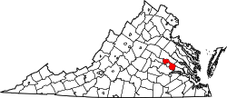
Location of Henrico County in Virginia
This is a list of the National Register of Historic Places listings in Henrico County, Virginia.
This is intended to be a complete list of the properties and districts on the National Register of Historic Places in Henrico County, Virginia, United States. The locations of National Register properties and districts for which the latitude and longitude coordinates are included below, may be seen in a Google map.[1]
There are 30 properties and districts listed on the National Register in the county, including 2 National Historic Landmarks.
- This National Park Service list is complete through NPS recent listings posted December 2, 2016.[2]
Current listings
| [3] | Name on the Register[4] | Image | Date listed[5] | Location | City or town | Description |
|---|---|---|---|---|---|---|
| 1 | Beth Elon | Upload image | (#03000446) |
4600 Nine Mile Rd. 37°32′42″N 77°22′27″W / 37.545°N 77.374167°W |
Richmond | A simplified Queen Anne style house from 1890, that was home of Leslie and Laura Watson, musicians and music teachers in the Richmond area[6] |
| 2 | Brook Road Marker, Jefferson Davis Highway | 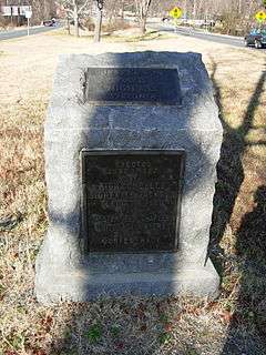 |
(#07000765) |
0.2 mi (0.32 km). E of jct. of Hilliard and Brook Rds. 37°37′04″N 77°27′26″W / 37.617836°N 77.457114°W |
Richmond | A marker for the Jefferson Davis Highway, conceived and marked by the United Daughters of the Confederacy, as a counter to the Lincoln Highway in the north, during 1913-1925 in an era of named highway promotion, before numbered U.S. highways were created.[7] |
| 3 | Clarke-Palmore House | 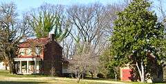 |
(#04000576) |
904 McCoul St. 37°30′28″N 77°24′24″W / 37.507778°N 77.406667°W |
Richmond | Brick house built as a farmhouse in 1819 and expanded in 1855; "a reminder of Henrico County's agricultural past."[8] |
| 4 | Curles Neck Farm | 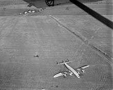 |
(#09001222) |
4705 Curles Neck Rd. 37°23′26″N 77°17′33″W / 37.390653°N 77.292383°W |
Henrico | Plantation operated continuously as a working farm since 1635. One of the great James River Plantations. Incidentally, site of an airplane crash-landing in 1951. Plantation house and 156 acres (0.63 km2) are NRHP-listed.[9] |
| 5 | Druin-Horner House | 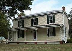 |
(#09000064) |
9904 River Rd. 37°35′09″N 77°36′38″W / 37.585956°N 77.610589°W |
Richmond | |
| 6 | Edge Hill | Upload image | (#08000243) |
Address Restricted |
Richmond | |
| 7 | Emek Sholom Holocaust Memorial Cemetery | 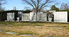 |
(#99000072) |
4000 Pilots Ln. 37°35′27″N 77°26′15″W / 37.590833°N 77.4375°W |
Richmond | |
| 8 | Emmanuel Church at Brook Hill | 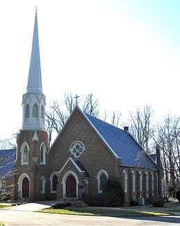 |
(#99001720) |
1214 Wilmer Ave. 37°36′21″N 77°27′31″W / 37.605833°N 77.458611°W |
Henrico County | A "superb example of late antebellum Gothic Revival ecclesiastical architecture", designed by Rhode Island architect Clifton A. Hall.[10] |
| 9 | Farmer's Rest | Upload image | (#15000015) |
9341 Varina Rd. 37°24′32″N 77°21′13″W / 37.4088°N 77.3536°W |
Henrico | |
| 10 | Flood Marker of 1771 | Upload image | (#71000981) |
0.8 mi (1.3 km). SE of jct. of VA 5 and VA 156 37°23′42″N 77°16′06″W / 37.395°N 77.268333°W |
Richmond | |
| 11 | Fort Harrison National Cemetery | 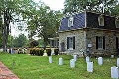 |
(#95000921) |
8620 Varina Rd. 37°25′42″N 77°22′00″W / 37.428333°N 77.366667°W |
Richmond | |
| 12 | Glendale National Cemetery | |
(#96000026) |
Jct of VA 156 and VA 600, 1 mi (1.6 km). S 37°26′09″N 77°14′05″W / 37.435833°N 77.234722°W |
Providence Forge | |
| 13 | Henrico Theatre | 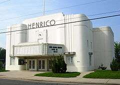 |
(#05001226) |
305 E. Nine Mile Rd. 37°32′44″N 77°19′35″W / 37.545556°N 77.326389°W |
Highland Springs | An Art Deco style building from 1938.[11] |
| 14 | James River and Kanawha Canal Historic District | 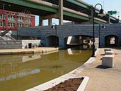 |
(#71000982) |
Extends from Ship Locks to Bosher's Dam 37°32′46″N 77°30′10″W / 37.546111°N 77.502778°W |
Richmond | |
| 15 | James River Steam Brewery Cellars | Upload image | (#13001162) |
4920 Old Main St. 37°30′58″N 77°24′57″W / 37.51616°N 77.415745°W |
Richmond | |
| 16 | Laurel Industrial School Historic District | 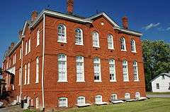 |
(#87001149) |
N & S sides of Hungary Rd. W of Old Staples Mill Rd. 37°38′35″N 77°30′37″W / 37.643056°N 77.510278°W |
Laurel | |
| 17 | Malvern Hill | 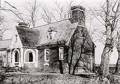 |
(#69000248) |
SE of jct. of Rtes. 5 and 156 37°23′52″N 77°14′28″W / 37.397778°N 77.241111°W |
Richmond | Site of bloody Battle of Malvern Hill on July 1, 1862. Cruciform-plan house built in 1600s, burned in 1905. Ruins, including end gables and chimney still "perhaps the finest example of seventeenth century diaper brickwork in the state."[12] |
| 18 | Mankin Mansion | 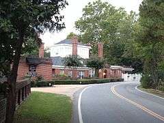 |
(#93001124) |
4300 Oakleys Ln. 37°32′10″N 77°20′50″W / 37.536111°N 77.347222°W |
Richmond | |
| 19 | Meadow Farm | 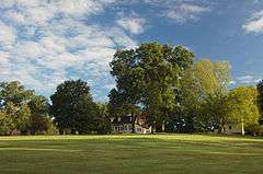 |
(#74002125) |
Mountain and Courtney Rds. 37°40′32″N 77°31′02″W / 37.675556°N 77.517222°W |
Glen Allen | |
| 20 | Virginia Randolph Cottage | .jpg) |
(#74002126) |
2200 Mountain Rd. 37°39′39″N 77°28′56″W / 37.660833°N 77.482222°W |
Glen Allen | Home economics building of the Virginia Randolph Training School, a vocational school, where Virginia E. Randolph (1874–1958), who was a black woman, was a teacher and a teacher educator for 55 years. Now a museum commemorating her life. Her gravesite is on the grounds.[13] |
| 21 | Redesdale | Upload image | (#08000071) |
8603 River Rd. 37°34′09″N 77°33′48″W / 37.569278°N 77.563239°W |
Richmond | |
| 22 | Reynolds Metals Company International Headquarters | 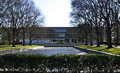 |
(#00000064) |
6601 W. Broad St. 37°36′05″N 77°31′12″W / 37.601389°N 77.52°W |
Richmond | International Style building complex set in a composed landscape, completed in 1958, cited as a prototype for modern suburban office development, and featuring aluminum inside and out.[14] |
| 23 | Richmond National Cemetery | 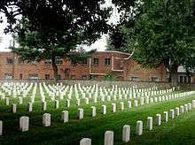 |
(#95001183) |
1701 Williamsburg Rd. 37°30′52″N 77°23′35″W / 37.514444°N 77.393056°W |
Richmond | |
| 24 | Rocky Mills | 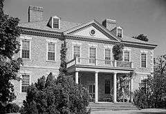 |
(#02000513) |
211 Ross Rd. 37°33′56″N 77°33′14″W / 37.565556°N 77.553889°W |
Richmond | |
| 25 | Seven Pines National Cemetery | |
(#95001182) |
400 E. Williamsburg Rd. 37°31′13″N 77°18′07″W / 37.520278°N 77.301944°W |
Sandston | |
| 26 | Tree Hill | Upload image | (#74002127) |
VA 5 37°29′46″N 77°24′49″W / 37.496111°N 77.413611°W |
Richmond | |
| 27 | Tuckahoe | 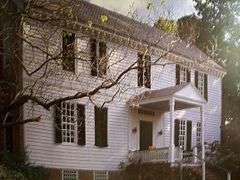 |
(#68000049) |
SE of Manakin near jct. of Rtes. 650 and 647 37°34′15″N 77°39′15″W / 37.570833°N 77.654167°W |
Manakin | Boyhood home of Thomas Jefferson (1745–1752).[15] The plantation spans border between Goochland and Henrico counties. |
| 28 | Varina Plantation | Upload image | (#77001489) |
Varina Road 37°22′54″N 77°20′09″W / 37.3817°N 77.3358°W |
Varina | |
| 29 | Walkerton | 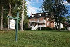 |
(#84000676) |
Mountain Rd. 37°39′53″N 77°29′38″W / 37.664722°N 77.493889°W |
Glen Allen | |
| 30 | Woodside | Upload image | (#73002021) |
SW of Tuckahoe off VA 157 37°34′26″N 77°37′14″W / 37.573889°N 77.620556°W |
Tuckahoe | A Greek Revival style villa built in 1858, the countryside home of the Wickham family of Richmond.[16] |
See also
| Wikimedia Commons has media related to National Register of Historic Places in Henrico County, Virginia. |
- List of National Historic Landmarks in Virginia
- National Register of Historic Places listings in Virginia
- National Register of Historic Places listings in Richmond, Virginia
References
- ↑ The latitude and longitude information provided in this table was derived originally from the National Register Information System, which has been found to be fairly accurate for about 99% of listings. For about 1% of NRIS original coordinates, experience has shown that one or both coordinates are typos or otherwise extremely far off; some corrections may have been made. A more subtle problem causes many locations to be off by up to 150 yards, depending on location in the country: most NRIS coordinates were derived from tracing out latitude and longitudes off of USGS topographical quadrant maps created under the North American Datum of 1927, which differs from the current, highly accurate WGS84 GPS system used by most on-line maps. Chicago is about right, but NRIS longitudes in Washington are higher by about 4.5 seconds, and are lower by about 2.0 seconds in Maine. Latitudes differ by about 1.0 second in Florida. Some locations in this table may have been corrected to current GPS standards.
- ↑ "National Register of Historic Places: Weekly List Actions". National Park Service, United States Department of the Interior. Retrieved on December 2, 2016.
- ↑ Numbers represent an ordering by significant words. Various colorings, defined here, differentiate National Historic Landmarks and historic districts from other NRHP buildings, structures, sites or objects.
- ↑ National Park Service (2008-04-24). "National Register Information System". National Register of Historic Places. National Park Service.
- ↑ The eight-digit number below each date is the number assigned to each location in the National Register Information System database, which can be viewed by clicking the number.
- ↑ Richard C. and Jeanne E. McNeil (September 1, 2002). "National Register of Historic Places Registration: Beth Elon" (PDF). Virginia Historic Landmarks Commission. Retrieved 2010-05-05. and Accompanying photo at Virginia Historic Landmarks Commission, undated
- ↑ Ruth D. Snead and Virginia Department of Historic Resources staff (2004). "UDC Commemorative Highway Markers along the Jefferson Davis Highway in Virginia" (PDF). National Park Service.
- ↑ Susan Reed Smither (January 29, 2004). "National Register of Historic Places Registration: Clarke-Palmore House / Clarke Home" (PDF). Virginia Historic Landmarks Commission. Retrieved 2010-05-08. and Accompanying four photos at Virginia Historic Landmarks Commission, undated
- ↑ Nancy W. Kraus (August 26, 2009). "National Register of Historic Places Registration: Curles Neck Farm / DHR File No. 043-0035 / Curles Neck Plantation" (PDF). Virginia Historic Landmarks Commission. Retrieved 2010-05-06. and Accompanying six photos at Virginia Historic Landmarks Commission, undated
- ↑ Virginia Historic Landmarks Commission staff (June 1999). "National Register of Historic Places Registration: Emmanuel Church at Brook Hill" (PDF). Virginia Historic Landmarks Commission. Retrieved 2010-05-06. and Accompanying photo at Virginia Historic Landmarks Commission, undated
- ↑ Bryan Clark Green and Susan Reed (June 7, 2005). "National Register of Historic Places Registration: Henrico Theatre" (PDF). Virginia Historic Landmarks Commission. Retrieved 2010-05-08. and Accompanying 4 photos at Virginia Historic Landmarks Commission, undated
- ↑ Virginia Historic Landmarks Commission staff (1967). "National Register of Historic Places Inventory/Nomination: Malvern Hill" (PDF). Virginia Historic Landmarks Commission. Retrieved 2010-05-27. and Accompanying 2 photos at Virginia Historic Landmarks Commission, undated
- ↑ James Sheire (July 31, 1974), National Register of Historic Places Inventory-Nomination: Virginia E. Randolph Museum - Virginia Cardwell Cottage / Home Economics Cottage (pdf), National Park Service and Accompanying one photo, undated (plus an unrelated photo of Poe Shrine, "oldest house" in Richmond, Virginia) (32 KB)
- ↑ Mary Harding Sadler and Peter McDearmon Witt (October 1, 1999). "National Register of Historic Places Registration: Reynolds Metals Company International Headquarters" (PDF). Virginia Historic Landmarks Commission. Retrieved 2010-05-08. and Accompanying four photos at Virginia Historic Landmarks Commission, undated
- ↑ "Tuckahoe National Register of Historic Places Nomination Form" (PDF). Virginia Department of Historic Resources. 1968. Retrieved 27 December 2008.
- ↑ Virginia Historic Landmarks Commission staff (December 1972). "National Register of Historic Places Registration: Woodside" (PDF). Virginia Historic Landmarks Commission. Retrieved 2010-05-08. and Accompanying photo at Virginia Historic Landmarks Commission, undated


Municipalities and communities of Henrico County, Virginia, United States | ||
|---|---|---|
| CDPs | | |
| Unincorporated communities | ||
This article is issued from Wikipedia - version of the 11/17/2016. The text is available under the Creative Commons Attribution/Share Alike but additional terms may apply for the media files.