National Register of Historic Places listings in Wise County, Virginia

Location of Wise County in Virginia
This is a list of the National Register of Historic Places listings in Wise County, Virginia.
This is intended to be a complete list of the properties and districts on the National Register of Historic Places in Wise County, Virginia, United States. The locations of National Register properties and districts for which the latitude and longitude coordinates are included below, may be seen in a Google map.[1]
There are 18 properties and districts listed on the National Register in the county.
- This National Park Service list is complete through NPS recent listings posted December 2, 2016.[2]
Current listings
| [3] |
Name on the Register |
Image |
Date listed[4] |
Location |
City or town |
Description |
|---|
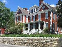
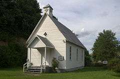
| 1 |
Christ Episcopal Church |
|
000000001990-12-19-0000December 19, 1990
(#89001905) |
100 Clinton Ave.
36°51′50″N 82°46′35″W / 36.863889°N 82.776389°W / 36.863889; -82.776389 (Christ Episcopal Church) |
Big Stone Gap |
|
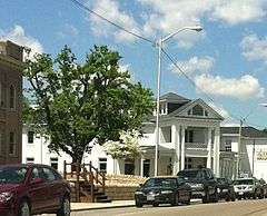
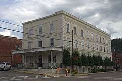
| 2 |
Colonial Hotel |
|
000000001991-02-05-0000February 5, 1991
(#91000019) |
Jct. of Main and Spring Sts.
36°58′39″N 82°34′51″W / 36.9775°N 82.580833°W / 36.9775; -82.580833 (Colonial Hotel) |
Wise |
|
| 3 |
Country Cabin |
|
000000001992-10-27-0000October 27, 1992
(#92001395) |
Jct. of US 23 and VA 790
36°55′35″N 82°40′24″W / 36.926389°N 82.673333°W / 36.926389; -82.673333 (Country Cabin) |
Norton |
|
| 4 |
Derby Historic District |
|
000000002004-01-16-0000January 16, 2004
(#03001436) |
VA 686, from a point beginning 1 mile (1.6 km) above the junction with VA 78 and extending for 1.2 miles (1.9 km) to the northwest
36°56′02″N 82°49′21″W / 36.933889°N 82.8225°W / 36.933889; -82.8225 (Derby Historic District) |
Appalachia |
|
| 5 |
Flat Gap High School |
|
000000002009-03-06-0000March 6, 2009
(#09000123) |
Rt. 671
37°05′00″N 82°41′36″W / 37.083333°N 82.693333°W / 37.083333; -82.693333 (Flat Gap High School) |
Pound |
|
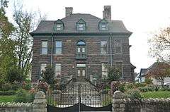
| 6 |
John Fox, Jr. House |
|
000000001974-06-07-0000June 7, 1974
(#74002151) |
117 Shawnee Ave.
36°51′57″N 82°46′42″W / 36.865833°N 82.778333°W / 36.865833; -82.778333 (John Fox, Jr. House) |
Big Stone Gap |
|
| 7 |
E. M. Fulton House |
|
000000002006-02-01-0000February 1, 2006
(#05001581) |
103 W. Main St.
36°58′48″N 82°34′50″W / 36.98°N 82.580556°W / 36.98; -82.580556 (E. M. Fulton House) |
Wise |
|
| 8 |
Kelly View School |
Upload image |
000000002006-08-30-0000August 30, 2006
(#06000752) |
Appalachia Elementary School, Norton Rd., US 23
36°55′37″N 82°44′39″W / 36.926944°N 82.744167°W / 36.926944; -82.744167 (Kelly View School) |
Appalachia |
|
| 9 |
St. Paul Historic District |
|
000000002011-06-08-0000June 8, 2011
(#11000351) |
Portions of 4th & 5th Aves., Russell & Broad Sts.
36°54′17″N 82°18′38″W / 36.904722°N 82.310556°W / 36.904722; -82.310556 (St. Paul Historic District) |
St. Paul |
|
| 10 |
Southwest Virginia Museum Historical State Park |
|
000000002002-11-22-0000November 22, 2002
(#02001362) |
10 W. Street N
36°51′48″N 82°46′49″W / 36.863333°N 82.780278°W / 36.863333; -82.780278 (Southwest Virginia Museum Historical State Park) |
Big Stone Gap |
|
| 11 |
Stonega Historic District |
|
000000002004-01-16-0000January 16, 2004
(#03001435) |
VA 600, from 0.1 mi. north of the junction with VA 685 to a point approximately 3 mi. to the northeast
36°57′11″N 82°47′29″W / 36.953056°N 82.791389°W / 36.953056; -82.791389 (Stonega Historic District) |
Appalachia |
|
| 12 |
Sunnydale Farm |
Upload image |
000000002011-06-08-0000June 8, 2011
(#11000352) |
12439 Sunnydale Farm Rd.
37°09′16″N 82°33′28″W / 37.154444°N 82.557778°W / 37.154444; -82.557778 (Sunnydale Farm) |
Pound |
|
| 13 |
Tacoma School |
|
000000001997-09-12-0000September 12, 1997
(#97001072) |
4408 Stone Mountain Rd.
36°56′06″N 82°31′56″W / 36.935°N 82.532222°W / 36.935; -82.532222 (Tacoma School) |
Coeburn |
|
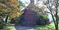
| 14 |
Terrace Park Girl Scout Cabin |
|
000000002007-11-01-0000November 1, 2007
(#07001146) |
211 Proctor St., N.
36°51′55″N 82°46′50″W / 36.865278°N 82.780556°W / 36.865278; -82.780556 (Terrace Park Girl Scout Cabin) |
Big Stone Gap |
|
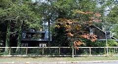
| 15 |
"June Tolliver" House |
|
000000001973-08-28-0000August 28, 1973
(#73002067) |
522 Clinton Ave E
36°52′02″N 82°46′22″W / 36.867222°N 82.772778°W / 36.867222; -82.772778 ("June Tolliver" House) |
Big Stone Gap |
|
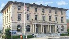
| 16 |
U.S. Post Office and Courthouse |
|
000000001975-12-23-0000December 23, 1975
(#75002043) |
322 Wood Ave. E.[5]
36°51′59″N 82°46′30″W / 36.866389°N 82.775°W / 36.866389; -82.775 (U.S. Post Office and Courthouse) |
Big Stone Gap |
|
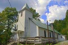
| 17 |
Virginia City Church |
|
000000002005-11-16-0000November 16, 2005
(#05001263) |
Bull Run Rd.
36°55′12″N 82°20′46″W / 36.92°N 82.346111°W / 36.92; -82.346111 (Virginia City Church) |
St. Paul |
|
| 18 |
Wise County Courthouse |
|
000000001981-03-02-0000March 2, 1981
(#81000649) |
206 E. Main Street
36°58′36″N 82°34′47″W / 36.976667°N 82.579722°W / 36.976667; -82.579722 (Wise County Courthouse) |
Wise |
|
See also
References
- ↑ The latitude and longitude information provided in this table was derived originally from the National Register Information System, which has been found to be fairly accurate for about 99% of listings. For about 1% of NRIS original coordinates, experience has shown that one or both coordinates are typos or otherwise extremely far off; some corrections may have been made. A more subtle problem causes many locations to be off by up to 150 yards, depending on location in the country: most NRIS coordinates were derived from tracing out latitude and longitudes off of USGS topographical quadrant maps created under the North American Datum of 1927, which differs from the current, highly accurate WGS84 GPS system used by most on-line maps. Chicago is about right, but NRIS longitudes in Washington are higher by about 4.5 seconds, and are lower by about 2.0 seconds in Maine. Latitudes differ by about 1.0 second in Florida. Some locations in this table may have been corrected to current GPS standards.
- ↑ "National Register of Historic Places: Weekly List Actions". National Park Service, United States Department of the Interior. Retrieved on December 2, 2016.
- ↑ Numbers represent an ordering by significant words. Various colorings, defined here, differentiate National Historic Landmarks and historic districts from other NRHP buildings, structures, sites or objects.
- ↑ The eight-digit number below each date is the number assigned to each location in the National Register Information System database, which can be viewed by clicking the number.
- ↑ Address based on USPS website. Accessed April 12, 2016.
|
|---|
|
Lists
by county | | |
|---|
|
Lists
by city | |
|---|
|
| Other lists | |
|---|
|
|