National Register of Historic Places listings in Lexington, Virginia
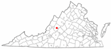
Location of Lexington in Virginia
This is a list of the National Register of Historic Places listings in Lexington, Virginia.
This is intended to be a complete list of the properties and districts on the National Register of Historic Places in the independent city of Lexington, Virginia, United States. The locations of National Register properties and districts for which the latitude and longitude coordinates are included below, may be seen in a Google map.[1]
There are 16 properties and districts listed on the National Register in the city, including 4 National Historic Landmarks.
- This National Park Service list is complete through NPS recent listings posted December 2, 2016.[2]
Current listings
| [3] |
Name on the Register[4] |
Image |
Date listed[5] |
Location |
Description |
|---|
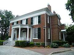
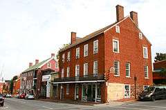
| 1 |
Alexander-Withrow House |
|
000000001971-07-02-0000July 2, 1971
(#71001055) |
Main and Washington Sts.
37°47′07″N 79°26′31″W / 37.785278°N 79.441944°W / 37.785278; -79.441944 (Alexander-Withrow House) |
|
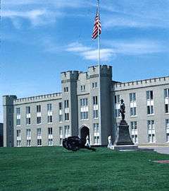
| 2 |
Barracks, Virginia Military Institute |
|
000000001966-10-15-0000October 15, 1966
(#66000956) |
Northern edge of Lexington on U.S. Route 11
37°47′25″N 79°26′19″W / 37.790278°N 79.438611°W / 37.790278; -79.438611 (Barracks, Virginia Military Institute) |
|
| 3 |
Blandome |
|
000000002002-01-24-0000January 24, 2002
(#01001520) |
101 Tucker St.
37°47′04″N 79°26′20″W / 37.784444°N 79.438889°W / 37.784444; -79.438889 (Blandome) |
|
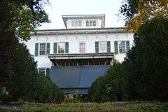
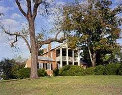
| 4 |
Col Alto |
|
000000001990-11-19-0000November 19, 1990
(#89001925) |
Nelson and Spottswood Dr.
37°46′49″N 79°26′21″W / 37.780278°N 79.439167°W / 37.780278; -79.439167 (Col Alto) |
|
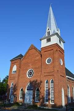
| 5 |
First Baptist Church-Lexington |
|
000000002006-08-30-0000August 30, 2006
(#06000757) |
103 N. Main St.
37°47′10″N 79°26′26″W / 37.786111°N 79.440556°W / 37.786111; -79.440556 (First Baptist Church-Lexington) |
|
| 6 |
Stonewall Jackson House |
|
000000001973-04-24-0000April 24, 1973
(#73002215) |
8 E. Washington St.
37°47′05″N 79°26′29″W / 37.784722°N 79.441389°W / 37.784722; -79.441389 (Stonewall Jackson House) |
|
| 7 |
Jordan's Point Historic District |
Upload image |
000000002016-08-15-0000August 15, 2016
(#16000530) |
Moses Mill Rd. & confluence of Maury R. & Woods Cr.
37°47′33″N 79°25′44″W / 37.792538°N 79.428818°W / 37.792538; -79.428818 (Jordan's Point Historic District) |
|
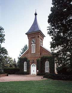
| 8 |
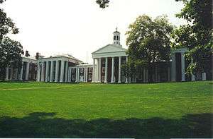
Lee Chapel, Washington and Lee University |
|
000000001966-10-15-0000October 15, 1966
(#66000914) |
Washington and Lee University campus
37°47′14″N 79°26′32″W / 37.787222°N 79.442222°W / 37.787222; -79.442222 (Lee Chapel, Washington and Lee University) |
|
| 9 |
Lexington and Covington Turnpike Toll House |
|
000000002004-11-27-0000November 27, 2004
(#04001268) |
453 Lime Kiln Rd.
37°47′11″N 79°27′16″W / 37.786389°N 79.454444°W / 37.786389; -79.454444 (Lexington and Covington Turnpike Toll House) |
|
| 10 |
Lexington Historic District |
|
000000001972-07-26-0000July 26, 1972
(#72001506) |
Roughly bounded by the former Chesapeake and Ohio railroad line, Graham and Jackson Aves., and Estill and Jordan Sts.
37°47′09″N 79°26′25″W / 37.785833°N 79.440278°W / 37.785833; -79.440278 (Lexington Historic District) |
|
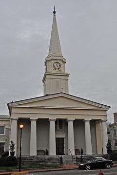
| 11 |
Lexington Presbyterian Church |
|
000000001979-05-24-0000May 24, 1979
(#79003282) |
Main and Nelson Sts.
37°47′02″N 79°26′35″W / 37.783889°N 79.443056°W / 37.783889; -79.443056 (Lexington Presbyterian Church) |
|
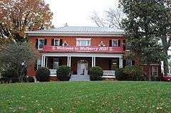
| 12 |
Mulberry Hill |
|
000000001982-09-09-0000September 9, 1982
(#82004671) |
Liberty Hall Rd.
37°47′N 79°27′W / 37.79°N 79.45°W / 37.79; -79.45 (Mulberry Hill) |
|
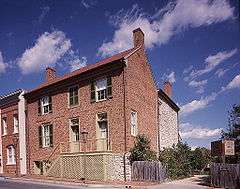
| 13 |
Reid-White-Philbin House |
|
000000002000-08-02-0000August 2, 2000
(#00000889) |
208 W. Nelson St.
37°47′08″N 79°26′45″W / 37.785556°N 79.445833°W / 37.785556; -79.445833 (Reid-White-Philbin House) |
|
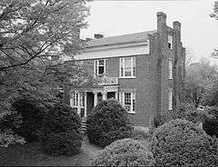
| 14 |
Stono |
|
000000001975-04-01-0000April 1, 1975
(#75002112) |
At the junction of U.S. Routes 11 and 11 Alt.
37°47′25″N 79°25′50″W / 37.790278°N 79.430556°W / 37.790278; -79.430556 (Stono) |
|
| 15 |
Virginia Military Institute Historic District |
|
000000001974-05-30-0000May 30, 1974
(#74002219) |
Virginia Military Institute campus
37°47′24″N 79°26′09″W / 37.79°N 79.435833°W / 37.79; -79.435833 (Virginia Military Institute Historic District) |
|
| 16 |
Washington and Lee University Historic District |
|
000000001971-11-11-0000November 11, 1971
(#71001047) |
Washington and Lee University campus
37°47′16″N 79°26′32″W / 37.787778°N 79.442222°W / 37.787778; -79.442222 (Washington and Lee University Historic District) |
|
See also
References
- ↑ The latitude and longitude information provided in this table was derived originally from the National Register Information System, which has been found to be fairly accurate for about 99% of listings. For about 1% of NRIS original coordinates, experience has shown that one or both coordinates are typos or otherwise extremely far off; some corrections may have been made. A more subtle problem causes many locations to be off by up to 150 yards, depending on location in the country: most NRIS coordinates were derived from tracing out latitude and longitudes off of USGS topographical quadrant maps created under the North American Datum of 1927, which differs from the current, highly accurate WGS84 GPS system used by most on-line maps. Chicago is about right, but NRIS longitudes in Washington are higher by about 4.5 seconds, and are lower by about 2.0 seconds in Maine. Latitudes differ by about 1.0 second in Florida. Some locations in this table may have been corrected to current GPS standards.
- ↑ "National Register of Historic Places: Weekly List Actions". National Park Service, United States Department of the Interior. Retrieved on December 2, 2016.
- ↑ Numbers represent an ordering by significant words. Various colorings, defined here, differentiate National Historic Landmarks and historic districts from other NRHP buildings, structures, sites or objects.
- ↑ National Park Service (2008-04-24). "National Register Information System". National Register of Historic Places. National Park Service.
- ↑ The eight-digit number below each date is the number assigned to each location in the National Register Information System database, which can be viewed by clicking the number.
|
|---|
|
Lists
by county | | |
|---|
|
Lists
by city | |
|---|
|
| Other lists | |
|---|
|
|
.jpg)