| [3] |
Name on the Register[4] |
Image |
Date listed[5] |
Location |
City or town |
Description |
|---|
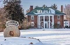
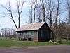
| 1 |
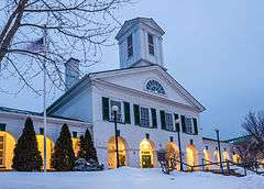
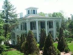
Aventine Hall |
|
000000001970-02-26-0000February 26, 1970
(#70000820) |
143 S. Court St.
38°39′49″N 78°27′53″W / 38.663611°N 78.464722°W / 38.663611; -78.464722 (Aventine Hall) |
Luray |
|
| 2 |
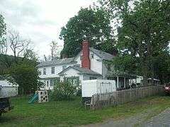
John Beaver House |
Upload image |
000000001979-06-22-0000June 22, 1979
(#79003065) |
N of Stanley on VA 615
38°37′48″N 78°33′47″W / 38.63°N 78.563056°W / 38.63; -78.563056 (John Beaver House) |
Salem |
|
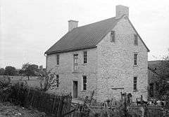
| 3 |
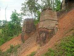
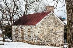
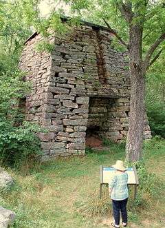
Catherine Furnace |
|
000000001974-01-21-0000January 21, 1974
(#74002141) |
2 mi. W of Newport in George Washington National Forest
38°33′28″N 78°38′09″W / 38.557778°N 78.635833°W / 38.557778; -78.635833 (Catherine Furnace) |
Newport |
|
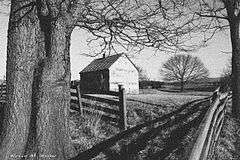
| 4 |
Fort Egypt |
|
000000001979-06-18-0000June 18, 1979
(#79003064) |
NW of Hamburg
38°39′44″N 78°31′47″W / 38.662222°N 78.529722°W / 38.662222; -78.529722 (Fort Egypt) |
Hamburg |
|
| 5 |
Fort Philip Long |
|
000000001973-04-11-0000April 11, 1973
(#73002048) |
Off VA 616 on Shenandoah River
38°36′20″N 78°33′44″W / 38.605556°N 78.562222°W / 38.605556; -78.562222 (Fort Philip Long) |
Stanley |
|
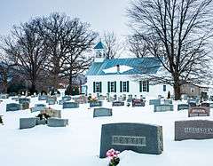
| 6 |
Graves Chapel and Cemetery |
|
000000002008-05-29-0000May 29, 2008
(#08000481) |
457 Chapel Rd.
38°34′35″N 78°29′09″W / 38.576275°N 78.485908°W / 38.576275; -78.485908 (Graves Chapel and Cemetery) |
Stanley |
|
| 7 |
Heiston-Strickler House |
Upload image |
000000001978-11-16-0000November 16, 1978
(#78003037) |
NW of Luray off VA 75
38°42′00″N 78°29′49″W / 38.7°N 78.496944°W / 38.7; -78.496944 (Heiston-Strickler House) |
Luray |
|
| 8 |
Jeremey's Run Site |
Upload image |
000000001985-12-13-0000December 13, 1985
(#85003175) |
Address Restricted
|
Luray |
|
| 9 |
Kanawha |
|
000000001999-08-05-0000August 5, 1999
(#99000968) |
4 Jamison Rd.
38°39′42″N 78°27′36″W / 38.661667°N 78.46°W / 38.661667; -78.46 (Kanawha) |
Luray |
|
| 10 |
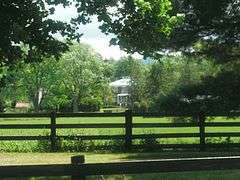
Locust Grove |
|
000000002015-12-08-0000December 8, 2015
(#15000879) |
6601 Ida Rd.
38°34′27″N 78°27′35″W / 38.574167°N 78.459731°W / 38.574167; -78.459731 (Locust Grove) |
Stanley |
|
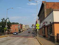
| 11 |
Luray Downtown Historic District |
|
000000002003-05-22-0000May 22, 2003
(#03000438) |
Roughly E. Main St., W. Main St., S. Court St., and s. Broad St.
38°40′11″N 78°27′53″W / 38.669722°N 78.464722°W / 38.669722; -78.464722 (Luray Downtown Historic District) |
Luray |
|
| 12 |
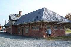
Luray Norfolk and Western Passenger Station |
|
000000002000-01-27-0000January 27, 2000
(#99001718) |
Jct. Campbell St. and Norfolk Southern Railway
38°39′50″N 78°27′38″W / 38.663889°N 78.460556°W / 38.663889; -78.460556 (Luray Norfolk and Western Passenger Station) |
Luray |
|
| 13 |
Massanutton Heights |
|
000000001976-07-30-0000July 30, 1976
(#76002117) |
W of Luray on U.S. 211
38°38′15″N 78°34′08″W / 38.6375°N 78.568889°W / 38.6375; -78.568889 (Massanutton Heights) |
Luray |
|
| 14 |
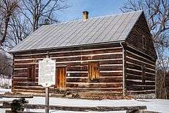
Mauck's Meetinghouse |
|
000000001976-06-18-0000June 18, 1976
(#76002116) |
Off U.S. 211
38°39′30″N 78°30′45″W / 38.658333°N 78.5125°W / 38.658333; -78.5125 (Mauck's Meetinghouse) |
Hamburg |
|
| 15 |
Milford Battlefield |
|
000000002004-08-11-0000August 11, 2004
(#04000854) |
VA 340 and VA 665
38°48′22″N 78°20′33″W / 38.806111°N 78.3425°W / 38.806111; -78.3425 (Milford Battlefield) |
Overall |
|
| 16 |
Mount Calvary Lutheran Church |
Upload image |
000000002008-06-03-0000June 3, 2008
(#98001068) |
279 Somers Rd.
38°37′45″N 78°25′33″W / 38.629067°N 78.425706°W / 38.629067; -78.425706 (Mount Calvary Lutheran Church) |
Luray |
Address taken from Registration Form posted at the Virginia Department of Historic Resources website[6]
|
| 17 |
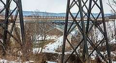
Page County Bridge No. 1990 |
|
000000002008-05-15-0000May 15, 2008
(#08000423) |
US 340
38°48′22″N 78°20′56″W / 38.806064°N 78.348936°W / 38.806064; -78.348936 (Page County Bridge No. 1990) |
Overall |
|
| 18 |
Page County Courthouse |
|
000000001973-06-25-0000June 25, 1973
(#73002047) |
116 S. Court St.
38°39′51″N 78°27′55″W / 38.664167°N 78.465278°W / 38.664167; -78.465278 (Page County Courthouse) |
Luray |
|
| 19 |
Abram and Sallie Printz Farm |
|
000000001999-08-12-0000August 12, 1999
(#99001006) |
597 Rosedale Ln.
38°37′21″N 78°24′24″W / 38.6225°N 78.406667°W / 38.6225; -78.406667 (Abram and Sallie Printz Farm) |
Luray |
|
| 20 |
Redwell-Isabella Furnace Historic District |
|
000000002005-07-27-0000July 27, 2005
(#05000762) |
Bet. VA 652 and Hawksbill Creek on N side of Luray
38°40′50″N 78°27′28″W / 38.680556°N 78.457778°W / 38.680556; -78.457778 (Redwell-Isabella Furnace Historic District) |
Luray |
|
| 21 |
Ruffner House |
|
000000002002-01-24-0000January 24, 2002
(#01001515) |
440 Ruffner House Ln.
38°40′14″N 78°27′18″W / 38.670556°N 78.455°W / 38.670556; -78.455 (Ruffner House) |
Luray |
|
| 22 |
Shenandoah Historic District |
|
000000002004-05-27-0000May 27, 2004
(#04000554) |
Parts of First,Second,Third,Fourth,Fifth,Sixth,Seventh,Eight Denver,Long,H,Sts, Central,Maryland, Penn, and Virg. Aves.
38°29′19″N 78°37′27″W / 38.488611°N 78.624167°W / 38.488611; -78.624167 (Shenandoah Historic District) |
Shenandoah |
|
| 23 |
Shenandoah Land and Improvement Company Office |
Upload image |
000000001978-07-14-0000July 14, 1978
(#78003038) |
201 Maryland Ave.
38°29′02″N 78°37′23″W / 38.483889°N 78.623056°W / 38.483889; -78.623056 (Shenandoah Land and Improvement Company Office) |
Shenandoah |
|
| 24 |
Skyline Drive Historic District |
|
000000001997-04-28-0000April 28, 1997
(#97000375) |
Shenandoah National Park, from the northern entrance station at Front Royal to the southern entrance station at Rockfish Gap; also within Shenandoah National Park, the areas known as Headquarters, Big Meadows, Dickey Ridge, Simmons Gap, and Piney River; also within Shenandoah National Park, the Skyland, Lewis Mountain, and Big Meadows
38°32′54″N 78°27′38″W / 38.548333°N 78.460556°W / 38.548333; -78.460556 (Skyline Drive Historic District) |
Luray |
Second and third sets of boundaries represent boundary increases of 000000001997-09-19-0000September 19, 1997 and 000000002003-12-05-0000December 5, 2003; designated a National Historic Landmark on 000000002008-10-06-0000October 6, 2008
|
| 25 |
Isaac Spitler House |
Upload image |
000000001997-05-23-0000May 23, 1997
(#97000486) |
2948 Oak Forest Ln.
38°37′42″N 78°30′20″W / 38.628333°N 78.505556°W / 38.628333; -78.505556 (Isaac Spitler House) |
Luray |
|
| 26 |
Stover House |
|
000000001978-05-22-0000May 22, 1978
(#78003189) |
N of Luray off VA 660
38°43′32″N 78°27′28″W / 38.725556°N 78.457778°W / 38.725556; -78.457778 (Stover House) |
Luray |
|
| 27 |
Strickley-Louderback House |
Upload image |
000000002000-11-22-0000November 22, 2000
(#00001441) |
1001 Old Farm Rd.
38°32′04″N 78°34′51″W / 38.534444°N 78.580833°W / 38.534444; -78.580833 (Strickley-Louderback House) |
Shenandoah |
|
| 28 |
Wall Brook Farm |
Upload image |
000000002002-11-22-0000November 22, 2002
(#02001375) |
967 Longs Rd.
38°37′52″N 78°32′43″W / 38.631111°N 78.545278°W / 38.631111; -78.545278 (Wall Brook Farm) |
Luray |
|
| 29 |
Welfley-Shuler House |
Upload image |
000000001999-12-22-0000December 22, 1999
(#99001604) |
449 Shipyard Rd.
38°30′03″N 78°38′03″W / 38.500833°N 78.634167°W / 38.500833; -78.634167 (Welfley-Shuler House) |
Shenandoah |
|
| 30 |
The White House |
|
000000002013-12-24-0000December 24, 2013
(#13000992) |
1917 Kauffmans Mill Rd.
38°38′52″N 78°32′04″W / 38.647713°N 78.534372°W / 38.647713; -78.534372 (The White House) |
Luray |
|
.jpg)