National Register of Historic Places listings in Charlotte County, Virginia
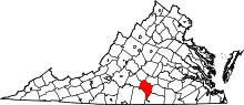
Location of Charlotte County in Virginia
This is a list of the National Register of Historic Places listings in Charlotte County, Virginia.
This is intended to be a complete list of the properties and districts on the National Register of Historic Places in Charlotte County, Virginia, United States. The locations of National Register properties and districts for which the latitude and longitude coordinates are included below, may be seen in a Google map.[1]
There are 19 properties and districts listed on the National Register in the county.
- This National Park Service list is complete through NPS recent listings posted November 25, 2016.[2]
Current listings
| [3] |
Name on the Register[4] |
Image |
Date listed[5] |
Location |
City or town |
Description |
|---|
| 1 |
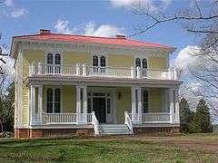
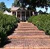
Annefield |
|
000000002009-11-12-0000November 12, 2009
(#09000920) |
3200 Sunny Side Rd.
36°55′41″N 78°34′18″W / 36.928006°N 78.571639°W / 36.928006; -78.571639 (Annefield) |
Saxe |
|
| 2 |
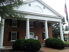
Charlotte County Courthouse |
|
000000001980-05-07-0000May 7, 1980
(#80004178) |
VA 40 and VA 47
37°03′20″N 78°38′16″W / 37.055556°N 78.637778°W / 37.055556; -78.637778 (Charlotte County Courthouse) |
Charlotte Court House |
|
| 3 |
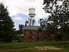
Charlotte Court House Historic District |
|
000000001995-02-08-0000February 8, 1995
(#95000023) |
VA 40 between VA 645 and VA 47
37°03′26″N 78°38′39″W / 37.057222°N 78.644167°W / 37.057222; -78.644167 (Charlotte Court House Historic District) |
Charlotte Court House |
|
| 4 |
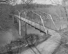
Clarkton Bridge |
|
000000002007-01-26-0000January 26, 2007
(#06000747) |
Clarkton Bridge Rd. over the Staunton River
36°58′40″N 78°53′49″W / 36.977778°N 78.896944°W / 36.977778; -78.896944 (Clarkton Bridge) |
Nathalie |
Extends into Halifax County
|
| 5 |
Four Locust Farm |
|
000000002009-12-03-0000December 3, 2009
(#09001053) |
U.S. Route 15
37°03′30″N 78°28′47″W / 37.058267°N 78.479611°W / 37.058267; -78.479611 (Four Locust Farm) |
Keysville |
|
| 6 |
Gravel Hill |
Upload image |
000000002001-02-16-0000February 16, 2001
(#01000150) |
3990 Fearstown Rd.
37°02′11″N 78°44′41″W / 37.036389°N 78.744722°W / 37.036389; -78.744722 (Gravel Hill) |
Charlotte Court House |
|
| 7 |
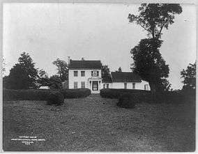
Greenfield |
Upload image |
000000001973-04-02-0000April 2, 1973
(#73002000) |
E of Charlotte Court House on VA 656
37°04′06″N 78°34′56″W / 37.068333°N 78.582222°W / 37.068333; -78.582222 (Greenfield) |
Charlotte Court House |
|
| 8 |
Keysville Railroad Station |
|
000000002008-11-12-0000November 12, 2008
(#08001050) |
Railroad Ave.
37°02′23″N 78°29′06″W / 37.039722°N 78.485000°W / 37.039722; -78.485000 (Keysville Railroad Station) |
Keysville |
|
| 9 |
Maple Roads |
Upload image |
000000002002-09-14-0000September 14, 2002
(#02000999) |
1325 Richardson Rd.
37°03′48″N 78°31′19″W / 37.063333°N 78.521944°W / 37.063333; -78.521944 (Maple Roads) |
Keysville |
|
| 10 |
Mulberry Hill |
Upload image |
000000001973-03-20-0000March 20, 1973
(#73002001) |
N of Randolph on VA 641
36°54′29″N 78°41′49″W / 36.908056°N 78.696944°W / 36.908056; -78.696944 (Mulberry Hill) |
Randolph |
|
| 11 |
Red Hill |
|
000000001978-02-14-0000February 14, 1978
(#78003012) |
SE of Brookneal on SR 677
37°01′52″N 78°53′44″W / 37.031111°N 78.895556°W / 37.031111; -78.895556 (Red Hill) |
Brookneal |
|
| 12 |
Roanoke Plantation |
Upload image |
000000001973-04-11-0000April 11, 1973
(#73002002) |
W of Saxe off VA 746
36°54′45″N 78°42′50″W / 36.9125°N 78.713889°W / 36.9125; -78.713889 (Roanoke Plantation) |
Saxe |
|
| 13 |
Salem School |
Upload image |
000000001998-10-30-0000October 30, 1998
(#98001309) |
Jct. of Rtes. 608 and 632
36°46′10″N 78°38′14″W / 36.769444°N 78.637222°W / 36.769444; -78.637222 (Salem School) |
Red Oak |
|
| 14 |
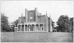
Staunton Hill |
|
000000001969-10-01-0000October 1, 1969
(#69000229) |
SW of jct. of Rtes. 619 and 693
37°00′27″N 78°51′59″W / 37.0075°N 78.866389°W / 37.0075; -78.866389 (Staunton Hill) |
Brookneal |
|
| 15 |
Toombs Tobacco Farm |
Upload image |
000000002000-01-28-0000January 28, 2000
(#00000027) |
1125 Tates Mill Rd.
36°47′04″N 78°35′36″W / 36.784444°N 78.593333°W / 36.784444; -78.593333 (Toombs Tobacco Farm) |
Red Oak |
|
| 16 |
Wade Archeological Site (44CH0062) |
Upload image |
000000002003-10-23-0000October 23, 2003
(#03001194) |
1035 Fort Hill Trail
36°53′13″N 78°42′17″W / 36.886944°N 78.704722°W / 36.886944; -78.704722 (Wade Archeological Site (44CH0062)) |
Randolph |
|
| 17 |
Watkins House |
Upload image |
000000002004-05-27-0000May 27, 2004
(#04000549) |
3115 Briery Rd.
37°04′20″N 78°30′25″W / 37.072222°N 78.506944°W / 37.072222; -78.506944 (Watkins House) |
Keysville |
|
| 18 |
Westview |
Upload image |
000000002000-02-04-0000February 4, 2000
(#00000067) |
1672 Terrell Rd.
37°01′37″N 78°51′53″W / 37.026944°N 78.864722°W / 37.026944; -78.864722 (Westview) |
Brookneal |
|
| 19 |
Woodfork |
Upload image |
000000002002-01-24-0000January 24, 2002
(#01001509) |
3704 Woodfork Rd.
37°06′05″N 78°39′56″W / 37.101389°N 78.665556°W / 37.101389; -78.665556 (Woodfork) |
Charlotte Court House |
|
See also
References
- ↑ The latitude and longitude information provided in this table was derived originally from the National Register Information System, which has been found to be fairly accurate for about 99% of listings. For about 1% of NRIS original coordinates, experience has shown that one or both coordinates are typos or otherwise extremely far off; some corrections may have been made. A more subtle problem causes many locations to be off by up to 150 yards, depending on location in the country: most NRIS coordinates were derived from tracing out latitude and longitudes off of USGS topographical quadrant maps created under the North American Datum of 1927, which differs from the current, highly accurate WGS84 GPS system used by most on-line maps. Chicago is about right, but NRIS longitudes in Washington are higher by about 4.5 seconds, and are lower by about 2.0 seconds in Maine. Latitudes differ by about 1.0 second in Florida. Some locations in this table may have been corrected to current GPS standards.
- ↑ "National Register of Historic Places: Weekly List Actions". National Park Service, United States Department of the Interior. Retrieved on November 25, 2016.
- ↑ Numbers represent an ordering by significant words. Various colorings, defined here, differentiate National Historic Landmarks and historic districts from other NRHP buildings, structures, sites or objects.
- ↑ National Park Service (2008-04-24). "National Register Information System". National Register of Historic Places. National Park Service.
- ↑ The eight-digit number below each date is the number assigned to each location in the National Register Information System database, which can be viewed by clicking the number.
|
|---|
|
Lists
by county | | |
|---|
|
Lists
by city | |
|---|
|
| Other lists | |
|---|
|
|