Exton, Pennsylvania
| Exton | |
| Census-designated place | |
 | |
| Country | United States |
|---|---|
| State | Pennsylvania |
| County | Chester |
| Township | West Whiteland |
| Elevation | 312 ft (95.1 m) |
| Coordinates | 40°01′59″N 75°37′40″W / 40.03306°N 75.62778°WCoordinates: 40°01′59″N 75°37′40″W / 40.03306°N 75.62778°W |
| Area | 3.2 sq mi (8.3 km2) |
| - land | 3.2 sq mi (8 km2) |
| - water | 0.0 sq mi (0 km2), 0% |
| Population | 4,842 (2010) |
| Density | 1,513.1/sq mi (584.2/km2) |
| Timezone | EST (UTC-5) |
| - summer (DST) | EDT (UTC-4) |
| ZIP codes | 19341, 19353 |
| Area code | 610 and 484 |
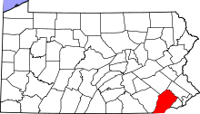
 Location in Chester County and the state of Pennsylvania. | |
.svg.png) Location of Pennsylvania in the United States | |
Exton is a census-designated place (CDP) in West Whiteland Township, Chester County, Pennsylvania, United States. Its population was 4,842 at the 2010 census. The Exton Square Mall and Main Street at Exton are both located within Exton along with several other shopping centers, making Exton the major shopping district in Chester County.
History
Exton lies at the intersection of U.S. Route 30 (formerly the Lancaster Road, and later the Lincoln Highway) and Pennsylvania Route 100 (Pottstown Pike). Beginning in the late 18th century, the Lancaster Road became a major transportation route between Philadelphia and the west, while what is now Route 100 was a regional north-south route to Pottstown. A theory exists that Exton was named as the "X" on the map, denoting this intersection, though more likely the village was named after one of the several Extons in the United Kingdom.
In the late 1940s, Exton became home to the Newcomen Society of the United States. The campus of the learned society was built overlooking farmland on Newcomen Road, and featured offices, a printing shop, library and museum, guest houses, a chapel and a belltower with a carillon. The Newcomen Society (since dissolved) sold the property in the late 1990s, but its campus remains an Exton landmark serving as the headquarters of another business.
Geography
According to the United States Census Bureau, the CDP has a total area of 3.2 square miles (8.3 km2), all of it land.
Demographics
As of the census[1] of 2000, there were 4,267 people, 2,053 households, and 1,096 families residing in the CDP. The population density was 1,341.6 people per square mile (518.1/km²). There were 2,128 housing units at an average density of 669.1/sq mi (258.4/km²). The racial makeup of the CDP was 88.07% White, 4.05% African American, 0.14% Native American, 6.05% Asian, 0.02% Pacific Islander, 0.54% from other races, and 1.12% from two or more races. Hispanic or Latino of any race were 1.87% of the population.
| Historical population | |||
|---|---|---|---|
| Census | Pop. | %± | |
| 1930 | 928 | — | |
| 1940 | 1,078 | 16.2% | |
| 1950 | 1,573 | 45.9% | |
| 1960 | 4,412 | 180.5% | |
| 1970 | 7,149 | 62.0% | |
| 1980 | 9,581 | 34.0% | |
| 1990 | 12,403 | 29.5% | |
| 2000 | 16,499 | 33.0% | |
| 2010 | 18,274 | 10.8% | |
| http://www.dvrpc.org/data/databull/rdb/db82/appedixa.xls. | |||
There were 2,053 households, out of which 20.9% had children under the age of 18 living with them, 45.4% were married couples living together, 5.8% had a female householder with no husband present, and 46.6% were non-families. 37.5% of all households were made up of individuals, and 7.9% had someone living alone who was 65 years of age or older. The average household size was 2.05 and the average family size was 2.75.
In the CDP the population was spread out, with 17.9% under the age of 18, 5.9% from 18 to 24, 43.3% from 25 to 44, 20.6% from 45 to 64, and 12.3% who were 65 years of age or older. The median age was 35 years. For every 100 females there were 92.6 males. For every 100 females age 18 and over, there were 90.8 males.
The median income for a household in the CDP was $68,240, and the median income for a family was $81,499. Males had a median income of $65,789 versus $42,778 for females. The per capita income for the CDP was $38,589. About 1.5% of families and 2.9% of the population were below the poverty line, including 1.1% of those under age 18 and 10.1% of those age 65 or over.
Climate
According to the Köppen Climate Classification system, Exton has a humid subtropical climate, abbreviated "Cfa" on climate maps.[2]
| Climate data for Exton, Pennsylvania | |||||||||||||
|---|---|---|---|---|---|---|---|---|---|---|---|---|---|
| Month | Jan | Feb | Mar | Apr | May | Jun | Jul | Aug | Sep | Oct | Nov | Dec | Year |
| Average high °C (°F) | 11 (51) |
16 (60) |
17 (62) |
22 (71) |
24 (75) |
30 (86) |
33 (91) |
32 (89) |
26 (78) |
21 (69) |
16 (61) |
15 (59) |
22 (71) |
| Average low °C (°F) | 9 (48) |
9 (48) |
3 (38) |
4 (39) |
9 (49) |
20 (68) |
17 (63) |
16 (61) |
12 (54) |
6 (42) |
1 (33) |
−4 (24) |
11 (51) |
| Average precipitation mm (inches) | 91 (3.6) |
84 (3.3) |
97 (3.8) |
94 (3.7) |
99 (3.9) |
114 (4.5) |
112 (4.4) |
114 (4.5) |
94 (3.7) |
84 (3.3) |
84 (3.3) |
97 (3.8) |
1,163 (45.8) |
| Source: Weatherbase [3] | |||||||||||||
Economy

Exton currently has an unemployment rate of 3.80% with a job growth rate of 1.44%. The future job growth is predicted to be 39.10% over the next ten years.[4] The opening of the Exton Square Mall led to rapid growth in West Whiteland Township, with the population increasing from 7,900 in 1973 to over 16,000 by 2000. Since the opening, many shopping centers and office parks have been built in the township. Following the opening of the mall, the West Whiteland Township Police Department was created to patrol the township as the demand from the mall would be too much for the Pennsylvania State Police to handle.[5] When the Exton Square Mall first opened, several stores in downtown West Chester closed.[6] In 2011, the Exton Square Mall saw sales per square foot of $332.[7]
Education
Schools
Exton is served by two public school districts, Downingtown Area School District and West Chester Area School District. Downingtown Area School District's Downingtown High School East Campus and Lionville Middle School, as well as West Chester School District's Exton Elementary, are located in Exton. Other schools in Exton are the Catholic parish school Saints Philip and James and the Church Farm School. Troy University has a learning site in Exton. Exton is home to the offices of 21st Century Cyber Charter School, a statewide cyber school that is known for being the only cyber school to make Pennsylvania's AYP (Adequate Yearly Progress) benchmark 5 years in a row.[8]
Both Widener University and the Delaware County Community College operate in Exton in the Whiteland Business Park.
Library

The Exton Library, the main library of the Chester County Library System is accessible from the mall. The building was dedicated to honor Congressman Paul Dague in 1971.[9] In 1982, the library in Exton received a National Association of Counties Award for its Library Literacy Program, the first in the U.S. state of Pennsylvania handling 30,000 illiterates and 15,000 non-English speaking residents.[10]
Infrastructure

Roads
Exton is generally well served by a network of highways. The location is at the confluence of U.S. Route 202, U.S. Route 30, and PA 100, connecting traffic from Philadelphia, Lancaster, and Wilmington.
Transit
Exton is well served by the SEPTA Regional Rail at the Whitford and Exton train stations and the Exton Transportation Center located inside the Exton Square Mall complex.
The Exton Transportation Center is a SEPTA and Krapf bus transport bus terminal located on the eastern side of the Exton Square Mall. The station serves as a hub for transfers between SEPTA Routes 92 and 204 with service to the King of Prussia Mall, Paoli and Eagleview and Krapf Transit Route A to Downingtown and Coatesville.[11]
Rail service at the train station is provided by Amtrak's Keystone Service and Pennsylvanian line, as well as SEPTA's Paoli/Thorndale Line. The station is located close to the former Whiteland station served by the former Pennsylvania Railroad.
Health care
In 2012, the Main Line Health at Exton Square opened a 32,000 square foot facility with radiology, physical rehabilitation, occupational health, and other lab services in the areas of cancer treatment, family health, and cardiology.[12] According to the mall directory, the facility occupies the first floor of the complex situated between Macy's and Boscov's.[13] The design of the facility is similar to buildings where physician practices are grouped together.[14]
Notable people
- Atlanta Falcons quarterback Matt Ryan
- Actor Kerr Smith
Gallery
 Main Street at Commerce Drive
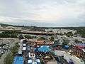 Exton Carnival 2014 at the Exton Square Mall
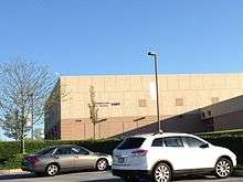
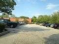 Delaware County Community College, Exton Center
 Northbound PA 100 shield past the interchange with U.S. Route 30
 Exton Transportation Center located beneath the garage near the library
- Exton train station
 Main Line Health Exton Square
References
- ↑ "American FactFinder". United States Census Bureau. Retrieved 2008-01-31.
- ↑ Climate Summary for Exton, Pennsylvania
- ↑ "Weatherbase.com". Weatherbase. 2013. Retrieved on October 24, 2013.
- ↑ "Exton, Pennsylvania".
- ↑ "The West Whiteland Township Police Department History". West Whiteland Township. Retrieved March 12, 2012.
- ↑ Whyte, William H. and Paco Underhill (1988). City: Rediscovering the Center. Doubleday. p. 337. Retrieved March 12, 2012.
- ↑ "Supplemental Financial and Operating Information". PREIT. December 31, 2011. Retrieved March 9, 2012.
- ↑ 21st Century Cyber School | PSSA Scores Retrieved 2010-04-22.
- ↑ Chester County - Page 37.
- ↑ Public Libraries and Nontraditional Clienteles: The Politics of ... - Page 88.
- ↑ "Rail Stations and Transportation Centers".
- ↑ "Main Line Health Center at Exton Square".
- ↑ "Exton Square Mall".
- ↑ "New Main Line Health Center at Exton Square opens<".
External links
| Wikimedia Commons has media related to Exton, Pennsylvania. |
-
 Exton travel guide from Wikivoyage
 - West Whiteland Township, PA
- Chester County Library
 |
|
| ||
| |
|
| ||
| ||||
| | ||||
| |