Dorlan, Pennsylvania
| Dorlan, Pennsylvania | |
| Populated place | |
| Country | United States |
|---|---|
| State | Pennsylvania |
| County | Chester |
| Township | East Brandywine |
| Elevation | 285 ft (86.9 m) |
| Coordinates | 40°2′51″N 75°42′59″W / 40.04750°N 75.71639°WCoordinates: 40°2′51″N 75°42′59″W / 40.04750°N 75.71639°W |
| Timezone | EST (UTC-5) |
| - summer (DST) | EDT (UTC-4) |
| ZIP code | 19335 |
| Area code | 610, 484 |
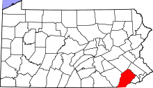
 Location of Dorlan in Pennsylvania
| |
 Location of Pennsylvania in the United States
| |
Dorlan is a populated place in Chester County, Pennsylvania, United States, along Pennsylvania Route 282 north of Downingtown and just south of Marsh Creek State Park. The place is referenced as an end point for the Struble Trail at Dorlan Mill Road.[1]
References
This article is issued from Wikipedia - version of the 4/22/2015. The text is available under the Creative Commons Attribution/Share Alike but additional terms may apply for the media files.