Parkesburg, Pennsylvania
| Parkesburg | |
|---|---|
| Borough | |
|
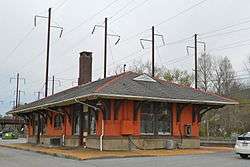
Amtrak station | |
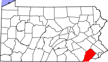
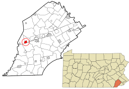 Location in Chester County and the state of Pennsylvania. | |
| Coordinates: 39°57′33″N 75°55′14″W / 39.95917°N 75.92056°WCoordinates: 39°57′33″N 75°55′14″W / 39.95917°N 75.92056°W | |
| Country | United States |
| State | Pennsylvania |
| County | Chester |
| Government | |
| • Mayor | John P. Hagan, II |
| Area | |
| • Total | 1.2 sq mi (3 km2) |
| • Land | 1.2 sq mi (3 km2) |
| • Water | 0 sq mi (0 km2) |
| Elevation | 528 ft (161 m) |
| Population (2010) | |
| • Total | 3,593 |
| • Density | 3,000/sq mi (1,200/km2) |
| Time zone | EST (UTC-5) |
| • Summer (DST) | EDT (UTC-4) |
| ZIP Code | 19365 |
| Area code(s) | 610 Exchange: 857 |
| Website | www.parkesburg.org |
Parkesburg is a borough in Chester County, Pennsylvania, United States. The population was 3,593 at the 2010 census. The ZIP code is 19365.
History
Parkesburg was first known as the Fountain Inn, a tavern built ca. 1734. The inn ceased operation as a tavern around 1836 and became Parkesburg's first post office. In 1872, the Pennsylvania legislature authorized the formation of Parkesburg Borough (from Sadsbury Township). The town was named after noted politician John G. Parke. Today, the Fountain Inn is a private residence.
The Parkesburg National Bank and Parkesburg School are listed on the National Register of Historic Places.[1]
Geography
Parkesburg is located at 39°57′33″N 75°55′14″W / 39.95917°N 75.92056°W (39.959066, -75.920447).[2]
According to the United States Census Bureau, the borough has a total area of 1.2 square miles (3.1 km2), all of it land.
Demographics
| Historical population | |||
|---|---|---|---|
| Census | Pop. | %± | |
| 1870 | 1,151 | — | |
| 1880 | 1,502 | 30.5% | |
| 1890 | 1,514 | 0.8% | |
| 1900 | 1,788 | 18.1% | |
| 1910 | 2,522 | 41.1% | |
| 1920 | 2,543 | 0.8% | |
| 1930 | 2,288 | −10.0% | |
| 1940 | 2,288 | 0.0% | |
| 1950 | 2,611 | 14.1% | |
| 1960 | 2,759 | 5.7% | |
| 1970 | 2,701 | −2.1% | |
| 1980 | 2,578 | −4.6% | |
| 1990 | 2,981 | 15.6% | |
| 2000 | 3,373 | 13.1% | |
| 2010 | 3,593 | 6.5% | |
| Est. 2015 | 3,687 | [3] | 2.6% |
| Sources:[4][5][6] | |||
At the 2010 census, the borough was 81.1% non-Hispanic White, 9.0% Black or African American, 0.9% Native American, 0.3% Asian, 0.1% Native Hawaiian or other Pacific Islander, and 2.1% were two or more races. 7.5% of the population were of Hispanic or Latino ancestry .
As of the census[5] of 2000, there were 3,373 people, 1,243 households, and 870 families residing in the borough. The population density was 2,706.8 people per square mile (1,041.9/km²). There were 1,321 housing units at an average density of 1,060.1 per square mile (408.0/km²). The racial makeup of the borough was 90.93% White, 6.88% African American, 0.15% Native American, 0.15% Asian, 0.03% Pacific Islander, 1.13% from other races, and 0.74% from two or more races. Hispanic or Latino of any race were 3.77% of the population.
There were 1,243 households, out of which 38.5% had children under the age of 18 living with them, 54.9% were married couples living together, 10.5% had a female householder with no husband present, and 30.0% were non-families. 26.4% of all households were made up of individuals, and 13.9% had someone living alone who was 65 years of age or older. The average household size was 2.70 and the average family size was 3.29.
In the borough the population was spread out, with 29.7% under the age of 18, 7.7% from 18 to 24, 31.8% from 25 to 44, 17.5% from 45 to 64, and 13.4% who were 65 years of age or older. The median age was 35 years. For every 100 females there were 93.0 males. For every 100 females age 18 and over, there were 87.9 males.
The median income for a household in the borough was $44,934, and the median income for a family was $55,726. Males had a median income of $38,482 versus $28,262 for females. The per capita income for the borough was $19,080. About 4.6% of families and 7.5% of the population were below the poverty line, including 11.0% of those under age 18 and 8.6% of those age 65 or over.
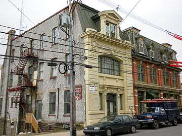 Parkesburg National Bank building
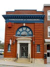 Farmers Bank of Parkesburg
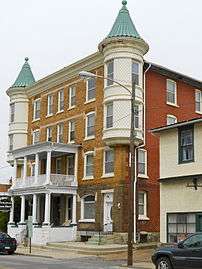 Parkesburg Arms Hotel
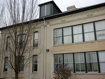 Parkesburg school
See also
References
- ↑ National Park Service (2010-07-09). "National Register Information System". National Register of Historic Places. National Park Service.
- ↑ "US Gazetteer files: 2010, 2000, and 1990". United States Census Bureau. 2011-02-12. Retrieved 2011-04-23.
- ↑ "Annual Estimates of the Resident Population for Incorporated Places: April 1, 2010 to July 1, 2015". Retrieved July 2, 2016.
- ↑ "Census of Population and Housing". U.S. Census Bureau. Archived from the original on May 11, 2015. Retrieved 11 December 2013.
- 1 2 "American FactFinder". United States Census Bureau. Archived from the original on September 11, 2013. Retrieved 2008-01-31.
- ↑ "Incorporated Places and Minor Civil Divisions Datasets: Subcounty Resident Population Estimates: April 1, 2010 to July 1, 2012". Population Estimates. U.S. Census Bureau. Archived from the original on June 17, 2013. Retrieved 11 December 2013.
External links
| Wikimedia Commons has media related to Parkesburg, Pennsylvania. |