Valley Township, Chester County, Pennsylvania
| Valley Township | |
|---|---|
| Township | |
|
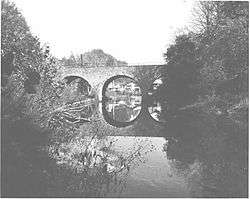
County Bridge No. 101 | |
 Location in Chester County and the state of Pennsylvania. | |
| Coordinates: 39°58′48″N 75°51′09″W / 39.98000°N 75.85250°WCoordinates: 39°58′48″N 75°51′09″W / 39.98000°N 75.85250°W | |
| Country | United States |
| State | Pennsylvania |
| County | Chester |
| Area | |
| • Total | 6.0 sq mi (16 km2) |
| • Land | 6.0 sq mi (16 km2) |
| • Water | 0.0 sq mi (0 km2) |
| Elevation | 640 ft (200 m) |
| Population (2010) | |
| • Total | 6,794 |
| • Density | 1,100/sq mi (440/km2) |
| Time zone | EST (UTC-5) |
| • Summer (DST) | EDT (UTC-4) |
| Area code(s) | 610 |
| Website | http://www.valleytownship.org |
Valley Township is a township in Chester County, Pennsylvania, United States. The population was 6,794 at the 2010 census.
History
County Bridge No. 101 and Hopewell Farm are listed on the National Register of Historic Places.[1]
Geography
According to the United States Census Bureau, the township has a total area of 6.0 square miles (16 km2), of which 0.17% is water.
Demographics
At the 2010 census, the township was 64.3% non-Hispanic White, 23.8% Black or African American, 0.2% Native American, 1.5% Asian, and 3.8% were two or more races. 7.5% of the population were of Hispanic or Latino ancestry .
As of the census[2] of 2000, there were 5,116 people, 1,874 households, and 1,362 families residing in the township. The population density was 857.1 people per square mile (330.9/km²). There were 1,974 housing units at an average density of 330.7/sq mi (127.7/km²). The racial makeup of the township was 75.10% White, 12.30% African American, 0.90% Native American, 3.60% Asian, 5.50% from other races, and 2.40% from two or more races. Hispanic or Latino of any race were 12.50% of the population.
There were 1,874 households, out of which 35.6% had children under the age of 18 living with them, 55.0% were married couples living together, 12.0% had a female householder with no husband present, and 27.3% were non-families. 22.3% of all households were made up of individuals, and 7.4% had someone living alone who was 65 years of age or older. The average household size was 2.66 and the average family size was 3.11.
| Historical population | |||
|---|---|---|---|
| Census | Pop. | %± | |
| 1930 | 2,735 | — | |
| 1940 | 2,663 | −2.6% | |
| 1950 | 3,148 | 18.2% | |
| 1960 | 3,101 | −1.5% | |
| 1970 | 3,791 | 22.3% | |
| 1980 | 3,598 | −5.1% | |
| 1990 | 4,007 | 11.4% | |
| 2000 | 5,116 | 27.7% | |
| 2010 | 6,794 | 32.8% | |
| http://www.dvrpc.org/data/databull/rdb/db82/appedixa.xls. | |||
In the township the population was spread out, with 26.5% under the age of 18, 6.2% from 18 to 24, 34.2% from 25 to 44, 20.8% from 45 to 64, and 12.3% who were 65 years of age or older. The median age was 36 years. For every 100 females there were 95.0 males. For every 100 females age 18 and over, there were 93.1 males.
The median income for a household in the township was $50,933, and the median income for a family was $58,712. Males had a median income of $37,451 versus $33,385 for females. The per capita income for the township was $20,648. About 3.5% of families and 5.2% of the population were below the poverty line, including 5.1% of those under age 18 and 4.2% of those age 65 or over.
Transportation
A general aviation airport, Chester County G. O. Carlson Airport, which allows private and corporate aircraft to easily access the town, is located in Valley Township. The airport is located about 2 miles (3 km) west of the center of the nearest major town, Coatesville.
References
- ↑ National Park Service (2010-07-09). "National Register Information System". National Register of Historic Places. National Park Service.
- ↑ "American FactFinder". United States Census Bureau. Retrieved 2008-01-31.