Franklin Township, Chester County, Pennsylvania
| Franklin Township | |
| Township | |
 House in Kemblesville | |
| Country | United States |
|---|---|
| State | Pennsylvania |
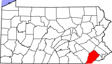
| County | Chester |
| Elevation | 302 ft (92.0 m) |
| Coordinates | 39°46′14″N 75°49′31″W / 39.77056°N 75.82528°WCoordinates: 39°46′14″N 75°49′31″W / 39.77056°N 75.82528°W |
| Area | 13.2 sq mi (34.2 km2) |
| - land | 13.2 sq mi (34 km2) |
| - water | 0.0 sq mi (0 km2), 0% |
| Population | 4,352 (2010) |
| Density | 329.7/sq mi (127.3/km2) |
| Timezone | EST (UTC-5) |
| - summer (DST) | EDT (UTC-4) |
| Area code | 610 |
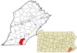 Location in Chester County and the state of Pennsylvania. | |
.svg.png) Location of Pennsylvania in the United States | |
| Website: http://www.franklintownship.us | |
Franklin Township is a township in Chester County, Pennsylvania, United States. The population was 4,352 at the 2010 census.
Geography
According to the United States Census Bureau, the township has a total area of 13.2 square miles (34 km2), all of it land.
The mailing addresses for the township include Landenberg, Lincoln University, and Kemblesville. The township abuts Maryland on its southern border, near the Fair Hill equestrian trails and grounds.
History
The southernmost part of the township was originally disputed territory between Pennsylvania and Maryland, resolved eventually by the Mason–Dixon line. The southernmost section of the township formed the northern section of New Munster, a large settlement tract established by Maryland and named after the southern province of Munster in Ireland.[1] New Munster acted as an early genesis point and catalyst for large Scotch-Irish settlement and expansion into Chester County and points west in Pennsylvania.[1][2][3] The Wooleston Grist Mill, also known as Tweed's Mill or Mackey's Mill, formed part of the New Munster tract and settlement.[4][5]
Part of the township was in the London Tract, land owned by the London Company from a land grant by William Penn in 1699.[6]
Demographics
| Historical population | |||
|---|---|---|---|
| Census | Pop. | %± | |
| 1930 | 620 | — | |
| 1940 | 655 | 5.6% | |
| 1950 | 666 | 1.7% | |
| 1960 | 817 | 22.7% | |
| 1970 | 1,043 | 27.7% | |
| 1980 | 1,920 | 84.1% | |
| 1990 | 2,779 | 44.7% | |
| 2000 | 3,850 | 38.5% | |
| 2010 | 4,352 | 13.0% | |
| www.dvrpc.org/data/databull/rdb/db82/appedixa.xls | |||
At the 2010 census, the township was 92.3% non-Hispanic White, 1.9% Black or African American, 0.1% Native American, 1.1% Asian, and 1.6% were two or more races. 6.4% of the population were of Hispanic or Latino ancestry.[7]
As of the census[8] of 2000, there were 3,850 people, 1,210 households, and 1,038 families residing in the township. The population density was 290.7 people per square mile (112.2/km2). There were 1,237 housing units at an average density of 93.4/sq mi (36.0/km2). The racial makeup of the township was 96.73% White, 1.12% African American, 0.18% Native American, 0.75% Asian, 0.49% from other races, and 0.73% from two or more races. Hispanic or Latino of any race were 1.27% of the population.
There were 1,210 households, out of which 53.1% had children under the age of 18 living with them, 77.6% were married couples living together, 5.6% had a female householder with no husband present, and 14.2% were non-families. 10.1% of all households were made up of individuals, and 2.6% had someone living alone who was 65 years of age or older. The average household size was 3.18 and the average family size was 3.45.
In the township the population was spread out, with 34.3% under the age of 18, 5.4% from 18 to 24, 31.0% from 25 to 44, 24.4% from 45 to 64, and 5.0% who were 65 years of age or older. The median age was 36 years. For every 100 females there were 99.2 males. For every 100 females age 18 and over, there were 96.8 males.
The median income for a household in the township was $81,085, and the median income for a family was $89,718. Males had a median income of $55,208 versus $36,250 for females. The per capita income for the township was $28,057. About 0.6% of families and 1.7% of the population were below the poverty line, including 0.8% of those under age 18 and 2.4% of those age 65 or over.
References
- 1 2 Johnston, G. (2009). History of Cecil County, Maryland. Genealogical Publishing Company. p. 135. ISBN 9780806379883. Retrieved 2014-12-06.
- ↑ "Pennsylvania: Scotch-Irish Centre". libraryireland.com. Retrieved 2014-12-06.
- ↑ Ford, H.J. (1915). The Scotch-Irish in America. Princeton University Press. p. 263. Retrieved 2014-12-06.
- ↑ "Mill List". millpictures.com. Retrieved 2014-12-06.
- ↑ Johnston, G. (2009). History of Cecil County, Maryland. Genealogical Publishing Company. p. 134. ISBN 9780806379883. Retrieved 2014-12-06.
- ↑
- ↑ "Census 2010: Pennsylvania". Usatoday.Com. Retrieved 2015-09-07.
- ↑ "American FactFinder". United States Census Bureau. Retrieved 2008-01-31.