Honey Brook, Pennsylvania
| Honey Brook Borough | |
| Borough | |
 Corner of US 322 and Rt 10 | |
| Country | United States |
|---|---|
| State | Pennsylvania |
| County | Chester |
| Elevation | 738 ft (224.9 m) |
| Coordinates | 40°05′39″N 75°54′35″W / 40.09417°N 75.90972°WCoordinates: 40°05′39″N 75°54′35″W / 40.09417°N 75.90972°W |
| Area | 0.5 sq mi (1.3 km2) |
| - land | 0.5 sq mi (1 km2) |
| - water | 0.0 sq mi (0 km2), 0% |
| Population | 1,713 (2010) |
| Density | 3,426.0/sq mi (1,322.8/km2) |
| Incorporated | 1891 |
| Mayor | Chris Mulhall |
| Timezone | EST (UTC-5) |
| - summer (DST) | EDT (UTC-4) |
| ZIP Code | 19344 |
| Area code | 610 and 484 |
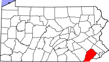
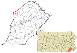 Location in Chester County and the state of Pennsylvania. | |
.svg.png) Location of Pennsylvania in the United States | |
| Website: http://www.honeybrookborough.net | |
Honey Brook is a borough located in Chester County, Pennsylvania, United States. The population of the borough was 1,713 at the 2010 census. The borough is surrounded by Honey Brook Township, and both are referred to locally collectively as Honey Brook.
History
Honey Brook Township was divided from Nantmeal Township in 1789. A schoolmaster and land developer named Stinson bought a plot of land along Horseshoe Pike in 1815. He had it surveyed and held a lottery to sell the lots for the town he called Waynesborough in honor of the Revolutionary War general, Mad Anthony Wayne. The residents changed the name to Honey Brook in 1884. Honey Brook is an incorrect English translation of the Welsh Nantmel, a village in Radnorshire, now part of Powys. The name 'Nantmel' actually means 'Mael's valley', Mael being a tenth-century prince. Honey Brook was incorporated as a borough in 1891.
The year 1884 brought more changes to the village and township. The railroad from Philadelphia-Downingtown-Lancaster was completed and ran along the south side of Horseshoe Pike. The railroad caused a problem for the village: there was another Waynesburg in western Pennsylvania. The freight was being routed to the wrong stations. Hence, the name was changed from Waynesburg to Honey Brook.
As the town grew, a petition was circulated in 1891 for the town to be incorporated into a borough. Almost every homeowner signed. With the incorporation as a borough, the main problems to overcome were: street lighting, sidewalks, and several years later, water.
The borough accepted public water in September 1896. Electric streetlights were installed after much discussion in 1915. Before that, gas lamps were used to light the streets. Over the years, boardwalks were replaced by bricks, then by concrete sidewalks. There are still two brick sidewalks in the borough. Horseshoe Pike, formerly Main Street, has the only fully paved sidewalks in the borough.
When the borough was incorporated, the census was around 600. As of the census in 2000, the population has doubled.
The oldest organization in Honey Brook Borough is the United Methodist Church. The longest continuous business is W.L. White’s & Sons.
Geography
Honey Brook is located at 40°5′39″N 75°54′35″W / 40.09417°N 75.90972°W (40.094260, -75.909799).[1]
According to the United States Census Bureau, the borough has a total area of 0.5 square miles (1.3 km2), all of it land. The borough lies on a ridge between the headwaters of the east and west branches of the Brandywine Creek.
Demographics
| Historical population | |||
|---|---|---|---|
| Census | Pop. | %± | |
| 1880 | 470 | — | |
| 1890 | 514 | 9.4% | |
| 1900 | 609 | 18.5% | |
| 1910 | 581 | −4.6% | |
| 1920 | 585 | 0.7% | |
| 1930 | 654 | 11.8% | |
| 1940 | 766 | 17.1% | |
| 1950 | 864 | 12.8% | |
| 1960 | 1,023 | 18.4% | |
| 1970 | 1,115 | 9.0% | |
| 1980 | 1,164 | 4.4% | |
| 1990 | 1,184 | 1.7% | |
| 2000 | 1,287 | 8.7% | |
| 2010 | 1,713 | 33.1% | |
| Est. 2015 | 1,758 | [2] | 2.6% |
| Sources:[3][4][5] | |||
At the 2010 census, the borough was 93.1% non-Hispanic White, 1.1% Black or African American, 0.2% Asian, 0.1% Native Hawaiian or other Pacific Islander, and 3.2% were two or more races. 3.5% of the population were of Hispanic or Latino ancestry .
As of the census[4] of 2000, there were 1,287 people, 474 households, and 337 families residing in the borough. The population density was 2,616.7 people per square mile (1,014.1/km²). There were 500 housing units at an average density of 1,016.6 per square mile (394.0/km²). The racial makeup of the borough was 97.1% White, 0.2% African American.
There were 474 households, out of which 41.4% had children under the age of 18 living with them, 56.8% were married couples living together, 11.2% had a female householder with no husband present, and 28.7% were non-families. 23.0% of all households were made up of individuals, and 14.3% had someone living alone who was 65 years of age or older. The average household size was 2.71 and the average family size was 3.22.
In the borough the population was spread out, with 29.6% under the age of 18, 8.6% from 18 to 24, 33.5% from 25 to 44, 15.8% from 45 to 64, and 12.5% who were 65 years of age or older. The median age was 33 years. For every 100 females there were 91.2 males. For every 100 females age 18 and over, there were 83.0 males.
The median income for a household in the borough was $46,319, and the median income for a family was $56,417. Males had a median income of $37,857 versus $28,636 for females. The per capita income for the borough was $19,205. About 6.2% of families and 7.4% of the population were below the poverty line, including 8.4% of those under age 18 and 2.5% of those age 65 or over.
Honey Brook is part of the Twin Valley School District.
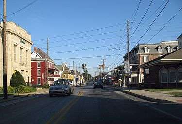 US 322 near State Route 10
 Presbyterian church
Notable people
- John Castle (1879–1929), Major League Baseball outfielder, minor league and college baseball manager
- Mat Madiro (b. 1991), metal band drummer
- Tom Patton (b. 1935), Major League Baseball catcher
- James Russell "Jim" Spotts (1909–1964), Major League Baseball catcher
- John C. Wenger (1910–1995), Mennonite theologian and professor
References
- ↑ "US Gazetteer files: 2010, 2000, and 1990". United States Census Bureau. 2011-02-12. Retrieved 2011-04-23.
- ↑ "Annual Estimates of the Resident Population for Incorporated Places: April 1, 2010 to July 1, 2015". Retrieved July 2, 2016.
- ↑ "Census of Population and Housing". U.S. Census Bureau. Retrieved 11 December 2013.
- 1 2 "American FactFinder". United States Census Bureau. Retrieved 2008-01-31.
- ↑ "Incorporated Places and Minor Civil Divisions Datasets: Subcounty Resident Population Estimates: April 1, 2010 to July 1, 2012". Population Estimates. U.S. Census Bureau. Retrieved 11 December 2013.
External links
| Wikimedia Commons has media related to Honey Brook, Pennsylvania. |