La Grange, Kentucky
| La Grange, Kentucky | |
|---|---|
| City | |
|
Downtown La Grange | |
 Location of La Grange, Kentucky | |
| Coordinates: 38°24′24″N 85°22′46″W / 38.40667°N 85.37944°WCoordinates: 38°24′24″N 85°22′46″W / 38.40667°N 85.37944°W | |
| Country | United States |
| State | Kentucky |
| County | Oldham |
| Incorporated | January 23, 1840 |
| Named for | Lafayette's French estate |
| Government | |
| • Type | Mayor-Council |
| • Mayor | Paul "Joe" Davenport |
| Area | |
| • Total | 7.14 sq mi (18.50 km2) |
| • Land | 7.06 sq mi (18.29 km2) |
| • Water | 0.08 sq mi (0.22 km2) |
| Elevation | 863 ft (263 m) |
| Population (2010) | |
| • Total | 8,082 |
| • Density | 1,131.4/sq mi (436.8/km2) |
| Time zone | Eastern (EST) (UTC-5) |
| • Summer (DST) | EDT (UTC-4) |
| ZIP codes | 40031–40032 |
| Area code(s) | 502 |
| FIPS code | 21-43480 |
| GNIS feature ID | 0495884 |
| Website |
www |
.JPG)
La Grange is a home rule-class city[1] in Oldham County, Kentucky, in the United States. The population was 8,082 at the time of the 2010 U.S. census. It is the seat of its county.[2]
History
La Grange was founded in 1827 when the Oldham county seat was relocated from Westport at the suggestion of Maj. William Berry Taylor. The new town was named for Château de la Grange-Bléneau, the French country estate of Gilbert du Motier, the American Revolutionary hero better known as the Marquis de Lafayette, who had visited the area in 1824.[3] For unknown reasons, the county seat returned to Westport from 1828–1838 before settling at La Grange. The city was formally incorporated by the state legislature on January 23, 1840.[4]
The La Grange Little League team participated in the 2011 Little League World Series.
Railroad

An unusual feature of La Grange is the CSX Transportation mainline on Main Street. The only other American city to have a street running mainline track is Oakland, California.
Commerce
The La Grange historic district contains numerous small businesses such as shops, eateries, and art galleries.
Discover Downtown La Grange is a non-profit organization dedicated to promoting business, history, and community in the city.[5]
La Grange hosts a Farmers and Artisan Market, a Kentucky Proud Market, where locally-made items are sold. The market is open from mid-May through late October.[6]
Correctional facilities
The Kentucky Department of Corrections maintains four correctional facilities in La Grange. Construction began on the Kentucky State Reformatory, the largest prison in the state, in 1937, with the prison opening in 1939. Roederer Correctional Complex, which houses the Assessment and Classification Center where male inmates not sentenced to death enter the state prison system, was built in 1976. The Luther Luckett Correctional Complex and Kentucky Correctional Psychiatric Center, both built in the same facility but technically two separate prisons, opened in 1983. Approximately 4,000 inmates of various security levels are housed at these institutions.
Geography
La Grange is located at 38°24′24″N 85°22′46″W / 38.40667°N 85.37944°W (38.406612, -85.379382).[7]
According to the United States Census Bureau, the city has a total area of 7.14 square miles (18.5 km2), of which 7.06 square miles (18.3 km2) is land and 0.84 square miles (2.2 km2) (1.17%) is water.
Climate
The climate in this area is characterized by hot, humid summers and generally mild to cool winters. According to the Köppen Climate Classification system, La Grange has a humid subtropical climate, abbreviated "Cfa" on climate maps.[8]
Demographics
| Historical population | |||
|---|---|---|---|
| Census | Pop. | %± | |
| 1840 | 233 | — | |
| 1870 | 612 | — | |
| 1880 | 490 | −19.9% | |
| 1890 | 670 | 36.7% | |
| 1900 | 646 | −3.6% | |
| 1910 | 1,152 | 78.3% | |
| 1920 | 1,060 | −8.0% | |
| 1930 | 1,121 | 5.8% | |
| 1940 | 1,334 | 19.0% | |
| 1950 | 1,558 | 16.8% | |
| 1960 | 2,168 | 39.2% | |
| 1970 | 1,713 | −21.0% | |
| 1980 | 2,971 | 73.4% | |
| 1990 | 3,853 | 29.7% | |
| 2000 | 5,676 | 47.3% | |
| 2010 | 8,082 | 42.4% | |
| Est. 2015 | 8,619 | [9] | 6.6% |
As of the census of 2010,[11] there were 8,082 people, 2,964 households, and 2,087 families residing in the city. The population density was 1131.4 people per square mile (436.8/km²). There were 3,189 housing units at an average density of 446.4 per square mile (172.4/km²). The racial makeup of the city was 87.3% White (83.5% non-Hispanic), 4.7% African American, 0.27% Native American, 0.62% Asian, 0.16% Pacific Islander, 4.6% from other races, and 2.3% from two or more races. Hispanics or Latinos of any race were 8.9% of the population.
There were 2,964 households out of which 43.1% had children under the age of 18 living with them, 49.9% were married couples living together, 15.5% had a single female householder, 5.1% had a single male householder, and 29.6% were non-families. 25.3% of all households were made up of individuals and 11.5% had someone living alone who was 65 years of age or older. The average household size was 2.65 and the average family size was 3.17.
The age distribution was 29.8% under 18, 7.2% from 18 to 24, 30.4% from 25 to 44, 20.4% from 45 to 64, and 11.7% who were 65 or older. The median age was 33.8 years. For every 100 females there were 92.7 males. For every 100 females age 18 and over, there were 86.6 males.
Full economic data for Kentucky locations from the 2010 Census has not yet been released. As of the 2010 Census, the median income for a household in the city was $46,422, and the median income for a family was $52,821. Full-time male workers had a median income of $48,511 versus $31,180 for females. The per capita income for the city was $20,921. As of the 2000 Census, about 9.1% of families and 10.8% of the population were below the poverty line, including 14.8% of those under age 18 and 7.5% of those age 65 or over.
Notable people
- Tom Blankenship (aka Two Tone Tommy), bassist for My Morning Jacket
- William J. Crowe, former Chairman of the Joint Chiefs of Staff
- Roland Isaacs, former NASCAR driver
- Robert Mallory, U.S. Representative from Kentucky
References
- ↑ "Summary and Reference Guide to House Bill 331 City Classification Reform" (PDF). Kentucky League of Cities. Retrieved December 30, 2014.
- ↑ "Find a County". National Association of Counties. Retrieved 2011-06-07.
- ↑ Rennick, Robert M. (1988). "Place Names". Kentucky Place Names. Lexington, Kentucky: The University Press of Kentucky. ISBN 0-8131-0179-4. Accessed 16 May 2010.
- ↑ Commonwealth of Kentucky. Office of the Secretary of State. Land Office. "La Grange, Kentucky". Accessed 1 Aug 2013.
- ↑ "LaGrange Crossroads Main Street - Kentucky". LaGrange Crossroads Main Street - Kentucky.
- ↑ http://discoverlagrange.org/special-events/farmers-market-artisans/
- ↑ "US Gazetteer files: 2010, 2000, and 1990". United States Census Bureau. 2011-02-12. Retrieved 2011-04-23.
- ↑ "Lagrange, Kentucky Köppen Climate Classification (Weatherbase)". Weatherbase.
- ↑ "Annual Estimates of the Resident Population for Incorporated Places: April 1, 2010 to July 1, 2015". Retrieved July 2, 2016.
- ↑ "Census of Population and Housing". Census.gov. Retrieved June 4, 2015.
- ↑ "American FactFinder". United States Census Bureau. Retrieved 2011-05-14.
External links
| Wikimedia Commons has media related to La Grange, Kentucky. |
- Official website
- Discover Downtown La Grange
- Downtown Rail video 1
- Downtown Rail video 2
- "La Grange: As a Crossroad, Area Won Designation as County Seat, Pulled in Train Business" — Article by Angela Struck of The Courier-Journal
Municipalities and communities of Oldham County, Kentucky, United States | ||
|---|---|---|
| Cities | 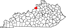 | |
| CDPs |
| |
| Unincorporated communities | ||
| Footnotes | ‡This populated place also has portions in an adjacent county or counties | |