Eddyville, Kentucky
| Eddyville, Kentucky | |
|---|---|
| City | |
|
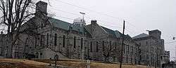
Kentucky State Penitentiary | |
 Location in Lyon County and the state of Kentucky. | |
| Coordinates: 37°4′50″N 88°4′10″W / 37.08056°N 88.06944°WCoordinates: 37°4′50″N 88°4′10″W / 37.08056°N 88.06944°W | |
| Country | United States |
| State | Kentucky |
| County | Lyon |
| Area | |
| • Total | 7.8 sq mi (20.1 km2) |
| • Land | 6.7 sq mi (17.3 km2) |
| • Water | 1.1 sq mi (2.8 km2) |
| Elevation | 509 ft (155 m) |
| Population (2010) | |
| • Total | 2,554 |
| • Density | 351.2/sq mi (135.6/km2) |
| Time zone | Central (CST) (UTC-6) |
| • Summer (DST) | CDT (UTC-5) |
| ZIP code | 42038 |
| Area code(s) | 270 & 364 |
| FIPS code | 21-23824 |
| GNIS feature ID | 0491553 |
Eddyville is a home rule-class city[1] in and the county seat of Lyon County, Kentucky, United States.[2] The population was 2,554 at the 2010 census, up from 2,350 in 2000. The Kentucky State Penitentiary is located at Eddyville.
History
Eddyville, the seat of Lyon County, was settled around 1798 and named for the eddies in the nearby Cumberland River.[3][4] It became the seat of Livingston County when it was formed in 1799; then the seat of Caldwell County upon its formation in 1809; and finally the seat of Lyon County upon its establishment in 1854. Thus, it holds the distinction of being the only city in Kentucky to have served as the county seat of three separate counties. The Eddyville post office opened in 1801.
Throughout Kentucky, Eddyville is best known as a metonym for the Kentucky State Penitentiary, although the prison itself is actually 3 miles (4.8 km) south of the present town on the shore of Lake Barkley in Old Eddyville on KY 730. Taking six years to build (1884–1890), the massive stone prison structure towers over Lake Barkley and is sometimes called "The Castle on the Cumberland". Its electric chair has had a long history of use, dating to the period before 1936 when executions were still publicly conducted in Kentucky for some crimes (e.g., rape as in the case of Rainey Bethea) while electrocutions at Eddyville were strictly reserved for others (e.g., murder). Executions are still held at the prison, although there have only been three since 1976 and only one since 1999. The primary method has been changed to lethal injection.
Following the completion of Kentucky Dam in the 1940s, rumors began that a dam would be built on the lower Cumberland. This meant relocating Eddyville and Kuttawa. By the mid-1950s, the people's fears were confirmed. The U.S. Army Corps of Engineers began surveying for the construction of Barkley Dam. The entire population of Eddyville was in a turmoil with decisions to be made. This ordeal caused many angry feelings among some of the residents, which lasted a lifetime.
It was about this time that Lee S. Jones entered the picture. Jones was a native of Lyon County who had attended law school and settled in Louisville, where he had gained a reputation as one of the best "tax lawyers" and also had accumulated enough money to be considered quite wealthy. Jones had purchased farms in the Fairview community (which is now the site of Eddyville). He came to the Eddyville City Council and presented his plan: each person owning land in the towns (Eddyville and Kuttawa) to be flooded would receive a free lot in the new Eddyville site. This also applied to businesses.
Eddyville residents accepted his offer and on August 13, 1959, the official plat for the new town was filed with the county court clerk. The plat included 254 residential lots, 46 business lots, 28 acres (110,000 m2) for construction of a school and campus, city park, courthouse, health office, water works, and location of streets.
August 28, 1959, was designated as "Dedication and Free Deed Day" at the new site. A large group of people gathered for the event which was held in a field (in front of where the post office is now located). Mr. Jones handed the first deed to Boyce and Lillian Yates, then presented approximately 60 more residential lots. The first house to be built in the new town was the home of Mr. and Mrs. J. I. Moore. The first business to be built was the Kentucky Utilities office. During the time of building, Eddyville was "booming" and, with the impoundment of Lake Barkley in the 1960s, tourists began making their way into the area for the abundance of fish and boating. The influx of tourists did not happen as rapidly as most people had envisioned and hoped. Although campgrounds and marinas were springing up around the lake, the city was struggling.
December 1988 brought the ground breaking for the West Kentucky Outlet Mall. Three brothers, Bob, Darrell and Ben Jent purchased a tract of land in the city limits of Eddyville and started construction of a mall, which opened the following fall with ten stores. Within a short time the mall would boast a total of nearly 50 stores. The opening of the mall brought a surge of progress to Eddyville, and all types of businesses began to move into the city. For the first time in the town's history, people could choose their favorite restaurant, motel, clothing store or other places to shop—all without leaving town. It has been said the mall did more for the progress of Eddyville than any other endeavor since the establishment of the town in 1799, with the possible exception of the building of the Kentucky State Penitentiary. The town was listed as the second fastest growing area in Kentucky in 1997 based on tourism.
The mall has since suffered severe economic troubles, and few stores are currently left.
Notable natives and residents
- Matthew Lyon - U.S. Representative
- John Long Routt — Governor of Colorado
- Chittenden Lyon — U.S. Representative
- Willis Benson Machen - Confederate States of America Congressman, United States Senator
- Hylan B. Lyon - Confederate Brigadier General
Geography
Eddyville is located at 37°4′50″N 88°4′10″W / 37.08056°N 88.06944°W (37.080671, -88.069479).[5]
According to the United States Census Bureau, the city has a total area of 7.8 square miles (20 km2), of which 6.7 square miles (17 km2) is land and 1.1 square miles (2.8 km2) (13.68%) is water.
Demographics
| Historical population | |||
|---|---|---|---|
| Census | Pop. | %± | |
| 1800 | 69 | — | |
| 1840 | 167 | — | |
| 1860 | 599 | — | |
| 1870 | 386 | −35.6% | |
| 1880 | 390 | 1.0% | |
| 1890 | 680 | 74.4% | |
| 1900 | 1,210 | 77.9% | |
| 1910 | 1,442 | 19.2% | |
| 1920 | 1,182 | −18.0% | |
| 1930 | 1,990 | 68.4% | |
| 1940 | 2,407 | 21.0% | |
| 1950 | 1,840 | −23.6% | |
| 1960 | 1,858 | 1.0% | |
| 1970 | 1,981 | 6.6% | |
| 1980 | 1,949 | −1.6% | |
| 1990 | 1,889 | −3.1% | |
| 2000 | 2,350 | 24.4% | |
| 2010 | 2,554 | 8.7% | |
| Est. 2015 | 2,577 | [6] | 0.9% |
As of the census[8] of 2000, there were 2,350 people, 733 households, and 452 families residing in the city. The population density was 351.2 people per square mile (135.6/km²). There were 882 housing units at an average density of 131.8 per square mile (50.9/km²). The racial makeup of the city was 85.96% White, 12.72% African American, 0.26% Native American, 0.13% Asian, 0.30% from other races, and 0.64% from two or more races. Hispanic or Latino of any race were 0.98% of the population.
There were 733 households out of which 24.4% had children under the age of 18 living with them, 48.8% were married couples living together, 10.9% had a female householder with no husband present, and 38.2% were non-families. 36.3% of all households were made up of individuals and 17.5% had someone living alone who was 65 years of age or older. The average household size was 2.10 and the average family size was 2.71.
In the city the population was spread out with 13.3% under the age of 18, 9.8% from 18 to 24, 40.5% from 25 to 44, 22.7% from 45 to 64, and 13.6% who were 65 years of age or older. The median age was 38 years. For every 100 females there were 182.8 males. For every 100 females age 18 and over, there were 197.4 males.
The median income for a household in the city was $28,472, and the median income for a family was $44,000. Males had a median income of $37,778 versus $21,845 for females. The per capita income for the city was $14,591. About 11.9% of families and 14.0% of the population were below the poverty line, including 15.2% of those under age 18 and 16.2% of those age 65 or over.
References
- ↑ "Summary and Reference Guide to House Bill 331 City Classification Reform" (PDF). Kentucky League of Cities. Retrieved December 30, 2014.
- ↑ "Find a County". National Association of Counties. Retrieved 2011-06-07.
- ↑ Rennick, Robert M. (1987). Kentucky Place Names. University Press of Kentucky. p. 89. Retrieved 2013-04-28.
- ↑ Gannett, Henry (1905). The Origin of Certain Place Names in the United States. Govt. Print. Off. p. 114.
- ↑ "US Gazetteer files: 2010, 2000, and 1990". United States Census Bureau. 2011-02-12. Retrieved 2011-04-23.
- ↑ "Annual Estimates of the Resident Population for Incorporated Places: April 1, 2010 to July 1, 2015". Retrieved July 2, 2016.
- ↑ "Census of Population and Housing". Census.gov. Retrieved June 4, 2015.
- ↑ "American FactFinder". United States Census Bureau. Retrieved 2008-01-31.
External links
Municipalities and communities of Lyon County, Kentucky, United States | ||
|---|---|---|
| Cities | 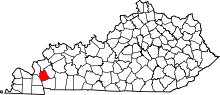 | |
| Unincorporated communities |
| |