Campbellsville, Kentucky
| Campbellsville, Kentucky | ||
|---|---|---|
| City | ||
|
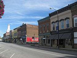
Downtown Campbellsville | ||
| ||
 Location of Campbellsville, Kentucky | ||
| Coordinates: 37°20′45″N 85°20′44″W / 37.34583°N 85.34556°WCoordinates: 37°20′45″N 85°20′44″W / 37.34583°N 85.34556°W | ||
| Country | United States | |
| State | Kentucky | |
| County | Taylor | |
| Area | ||
| • Total | 6.1 sq mi (15.7 km2) | |
| • Land | 6.0 sq mi (15.4 km2) | |
| • Water | 0.1 sq mi (0.2 km2) | |
| Elevation | 814 ft (248 m) | |
| Population (2012) | ||
| • Total | 10,759 | |
| • Density | 1,820.1/sq mi (679.9/km2) | |
| Time zone | Eastern (EST) (UTC-5) | |
| • Summer (DST) | EDT (UTC-4) | |
| ZIP codes | 42718-42719 | |
| Area code(s) | 270 & 364 | |
| FIPS code | 21-12160 | |
| GNIS feature ID | 0488742 | |
| Website | www.campbellsville.us | |

Campbellsville is in and the county seat of Taylor County, Kentucky, United States.[1] The population within city limits was 10,604 at the 2010 U.S. census. It is the site of Campbellsville University, a private institution. On the border is Green River Lake, established for flood control and now the center of a popular park.
Campbellsville is twinned with Buncrana in County Donegal, Republic of Ireland.
History
The city was founded in 1817 and laid out by Andrew Campbell, who had moved there from Augusta County, Virginia. Campbell owned a gristmill and a tavern and began selling lots in Campbellsville in 1814. Campbellsville was designated by the state legislature as the county seat in 1848 after Taylor County was separated from Green County. The city agreed to sell the public square to the county for one dollar so that a courthouse could be built here.
The first courthouse was burned by Confederate cavalry in 1864 because the Union Army was using it for barracks. After the war, a replacement courthouse was built on the same site. A third courthouse in a modern design was built in 1965 on a property adjoining the "old courthouse". A portion of the old courthouse still stands near the current (3rd) courthouse.
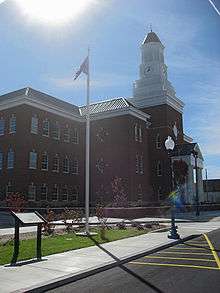
Construction began in 2008 on a new Justice Center because of the demand for a more modern courthouse. in addition, the city built an "official" county jail to avoid the cost of transporting and housing prisoners in neighboring Lebanon in Marion County.
Historic sites
Campbellsville has several historic sites as listed under Taylor County in the National Register of Historic Places listings in Kentucky. The Campbellsville Historic Commercial District includes several blocks of Main Street. The most notable structure in this district is Merchant Tower (formally Merchants Hotel) which has Romanesque architecture. It has been listed individually on the National Register of Historical Places since 1980.
Just north of Campbellsville is the Spurlington Tunnel, once used by local railroads, but which is no longer in service. It is about 1,900 feet long. Approximately one-third of the way in, a shaft leads to the top, where it once vented smoke from steam locomotives.
Downtown
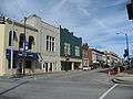
Downtown Campbellsville includes a Main Street and a designated historic district. The 100 and 200 blocks of Main Street are lined with century-old brick, stone, and iron buildings with Italianate architecture facades. Since 2008, Campbellsville has been redevelopig its downtown area with the help of a Main Street Manager, highlighting its historic design, improving pedestrian amenities and marketing this district. Campbellsville is known regionally for its Fourth Of July celebration.
-

Main Street South
-
Main Street North
-

Main Street Overhead
-

Fourth of July
Education
Campbellsville is home to a private university, Campbellsville University, founded in 1906 as an academy, and affiliated with the Kentucky Baptist Convention until 2014.
Campbellsville has two public schools Taylor County High School and Campbellsville High School.
Industry
In the 20th century, Campbellsville was a regional center of industry (agriculture, lumber, textiles, milling, automotive, distribution, oil and gas, light manufacturing, education, health care, and tourism).
In the 21st century, the local university, health care system, and ubiquitous access to the internet attract students and professionals.
For decades, employment in the area was dominated by a large textile plant, formerly Union Underwear and now Fruit of the Loom. It closed in 1998 along with (shortly thereafter) the Indiana-based Batesville Casket Company.[2] Amazon.com established a "regional fulfillment center" here, providing some jobs. Ten other businesses either located or relocated to Taylor County over the next several years.
Parker-Kalon Company, a division of Black and Decker Corporation, is located here as well. It has produced threaded and non-threaded fasteners for the automotive, appliance, metal building construction, and electronic industries since the late 1960s.
The area is home to wood milling companies that produce interior trim products (Cox Interior, Wholesale Hardwoods).
An expanding health care industry serves the region of 110,000 people. Taylor Regional Hospital is one of the largest employers. In 2008, TRH served 86,100 patients.[3]
In 1969, there was a booming oil business that was shut down due to environmental concerns of excess salt water disposal. In 2008, attempts were being made to revitalize oil reserves estimated at 200,000,000 barrels (32,000,000 m3) Original Oil-In-Place (OOIP).
Campbellsville Industries (CI), "The Steeple People (tm)," is the oldest and largest steeple and tower manufacturer in the United States.[4] CI has more than 15,000 installations located throughout the United States and Canada. CI claims the record for the world's largest prefabricated church steeple at 229' at the First Baptist Church in Huntsville, Alabama.[5]
Tourism is also part of the local economy due to the proximity of Green River Lake and Green River Lake State Park.
Campbellsville is also home to the last Druther's (a.k.a. Burger Queen) restaurant in existence.
Media
- The local twice-weekly newspaper, Central Kentucky News-Journal,[6] has been published since 1910.
- WVLC 99.9 FM - local country music-formatted radio station licensed to Mannsville
Geography
Campbellsville is located at 37°20′45″N 85°20′44″W / 37.34583°N 85.34556°W (37.345951, -85.345444).[7]
According to the United States Census Bureau, the city has a total area of 6.1 square miles (16 km2), of which 6.0 square miles (16 km2) is land and 0.1 square miles (0.26 km2) (1.65%) is water.
US 68, KY 55, KY 210, and KY 70 pass through Campbellsville.
Demographics
| Historical population | |||
|---|---|---|---|
| Census | Pop. | %± | |
| 1860 | 446 | — | |
| 1870 | 512 | 14.8% | |
| 1880 | 775 | 51.4% | |
| 1890 | 1,018 | 31.4% | |
| 1900 | 1,341 | 31.7% | |
| 1910 | 1,206 | −10.1% | |
| 1920 | 1,535 | 27.3% | |
| 1930 | 1,923 | 25.3% | |
| 1940 | 2,488 | 29.4% | |
| 1950 | 3,477 | 39.8% | |
| 1960 | 6,966 | 100.3% | |
| 1970 | 7,598 | 9.1% | |
| 1980 | 8,715 | 14.7% | |
| 1990 | 9,577 | 9.9% | |
| 2000 | 10,498 | 9.6% | |
| 2010 | 9,108 | −13.2% | |
| Est. 2015 | 11,237 | [8] | 23.4% |
As of the census[10] of 2010, there were 9.018 people, 3,764 households, and 2,160 families residing in the city. The population density was 1,760.9 people per square mile (680.1/km²). There were 4,114 housing units at an average density of 817.9 per square mile (315.9/km²). The racial makeup of the city was 89.11% White, 8.74% African American, 0.14% Native American, 0.30% Asian, 0.04% Pacific Islander, 0.61% from other races, and 1.06% from two or more races. Hispanic or Latino of any race were 1.17% of the population.
There were 4,114 households out of which 27.5% had children under the age of 18 living with them, 44.5% were married couples living together, 16.0% had a female householder with no husband present, and 36.5% were non-families. 33.4% of all households were made up of individuals and 16.5% had someone living alone who was 65 years of age or older. The average household size was 2.22 and the average family size was 2.80.
In the city the population was spread out with 21.8% under the age of 18, 14.0% from 18 to 24, 23.9% from 25 to 44, 21.8% from 45 to 64, and 18.5% who were 65 years of age or older. The median age was 38 years. For every 100 females there were 83.4 males. For every 100 females age 18 and over, there were 78.2 males.
The median income for a household in the city was $22,922, and the median income for a family was $30,643. Males had a median income of $26,672 versus $19,736 for females. The per capita income for the city was $15,996. About 18.7% of families and 21.6% of the population were below the poverty line, including 37.6% of those under age 18 and 17.5% of those age 65 or over.
Notable people
- Ray H. Altman, former state representative
- Sandra Blanton, former member of the Indiana House of Representatives; reared in Campbellsville
- John "Bam" Carney, current state representative
- Nancy Cox, 1990 Miss Kentucky; Lexington television reporter; born and reared in Campbellsville
- Ricky Lee Cox, former state representative
- Zack Cox, former Arkansas Razorback baseball player, Current professional baseball player
- Damon R. Eubank, American historian
- Fuller Harding (1915-2010), Campbellsville attorney who served in 1942 as a state representative for Taylor County
- Clem Haskins, former college and professional basketball player and college basketball coach at University of Minnesota
- J. B. Holmes, professional golfer
- Robert L. Miller (1927-2011), mayor of Campbellsville from 1966 to 1998
- Russ Mobley, state representative from 2001 to 2009
- Doug Moseley, former state senator; retired United Methodist pastor
- Paul E. Osborne, former mayor of Campbellsville
- Herman Rattliff (1926-2014), state representative from 1968 to 1986
- Forest Shely (1924-2010), physician who served fifty-six years on the Campbellsville University board of trustees
- Betty Jane Gorin-Smith, American historian and historic preservationist
- Gilbert R. Tredway, American historian; former Campbellsville University professor
- Kenneth W. Winters, former president of Campbellsville University; former member of the Kentucky State Senate
- Max Wise, Republican member of the Kentucky Senate
Climate
The climate in this area is characterized by hot, humid summers and generally mild to cool winters. According to the Köppen Climate Classification system, Campbellsville has a humid subtropical climate, abbreviated "Cfa" on climate maps.[11]
References
- ↑ "Find a County". National Association of Counties. Archived from the original on 2011-05-31. Retrieved 2011-06-07.
- ↑ "Company News; Fruit of Loom to Cut 800 Jobs in Another Plant Closing". New York Times. 1998-04-16.
- ↑ TRH 2008 Annual Report
- ↑ "Home". Cvilleindustries.com. Retrieved April 9, 2013.
- ↑ "Home". Cvilleindustries.com. Retrieved April 9, 2013.
- ↑ "CKNJ.com". CKNJ.com. Retrieved April 9, 2013.
- ↑ "US Gazetteer files: 2010, 2000, and 1990". United States Census Bureau. 2011-02-12. Retrieved 2011-04-23.
- ↑ "Annual Estimates of the Resident Population for Incorporated Places: April 1, 2010 to July 1, 2015". Retrieved July 2, 2016.
- ↑ "Census of Population and Housing". Census.gov. Archived from the original on May 11, 2015. Retrieved June 4, 2015.
- ↑ "American FactFinder". United States Census Bureau. Archived from the original on 2013-09-11. Retrieved 2008-01-31.
- ↑ Climate Summary for Campbellsville, Kentucky
External links
| Wikivoyage has a travel guide for Campbellsville, Kentucky. |
- http://www.campbellsville.com - A portal website by a private company.
- http://www.downtowncampbellsville.com - Merchant's website.
- http://www.merchanttower.com - Registered historic place. Official site.
- http://www.campbellsvillechamber.com - Chamber of Commerce
- http://www.teamtaylorcounty.com/ - Economic Development Authority
- http://www.campbellsvilleky.com/ - Tourism Commission
- http://parks.ky.gov/findparks/recparks/gr/ - Kentucky State Parks
Municipalities and communities of Taylor County, Kentucky, United States | ||
|---|---|---|
| City | 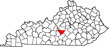 | |
| Unincorporated communities | ||