Andé
This article is about the place in France. For the place in Ivory Coast, see Andé, Ivory Coast. For the food, see Egg (food).
| Andé | ||
|---|---|---|
|
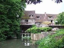
Mill | ||
| ||
 Andé | ||
|
Location within Normandy region  Andé | ||
| Coordinates: 49°13′59″N 1°14′36″E / 49.2331°N 1.2433°ECoordinates: 49°13′59″N 1°14′36″E / 49.2331°N 1.2433°E | ||
| Country | France | |
| Region | Normandy | |
| Department | Eure | |
| Arrondissement | Les Andelys | |
| Canton | Louviers-Nord | |
| Intercommunality | Seine-Eure | |
| Government | ||
| • Mayor (2008–2014) | Jean-Marc Moglia | |
| Area1 | 5.31 km2 (2.05 sq mi) | |
| Population (2008)2 | 1,057 | |
| • Density | 200/km2 (520/sq mi) | |
| Time zone | CET (UTC+1) | |
| • Summer (DST) | CEST (UTC+2) | |
| INSEE/Postal code | 27015 / 27430 | |
| Elevation |
7–48 m (23–157 ft) (avg. 45 m or 148 ft) | |
|
1 French Land Register data, which excludes lakes, ponds, glaciers > 1 km² (0.386 sq mi or 247 acres) and river estuaries. 2 Population without double counting: residents of multiple communes (e.g., students and military personnel) only counted once. | ||

Andé is a commune in the Eure department and Haute-Normandie region of France.
Population
| Historical population | ||
|---|---|---|
| Year | Pop. | ±% |
| 1793 | 378 | — |
| 1800 | 364 | −3.7% |
| 1806 | 367 | +0.8% |
| 1821 | 418 | +13.9% |
| 1831 | 435 | +4.1% |
| 1836 | 434 | −0.2% |
| 1841 | 434 | +0.0% |
| 1846 | 445 | +2.5% |
| 1851 | 431 | −3.1% |
| 1856 | 418 | −3.0% |
| 1861 | 420 | +0.5% |
| 1866 | 445 | +6.0% |
| 1872 | 435 | −2.2% |
| 1876 | 442 | +1.6% |
| 1881 | 421 | −4.8% |
| 1886 | 416 | −1.2% |
| 1891 | 404 | −2.9% |
| 1896 | 412 | +2.0% |
| 1901 | 391 | −5.1% |
| 1906 | 406 | +3.8% |
| 1911 | 410 | +1.0% |
| 1921 | 410 | +0.0% |
| 1926 | 387 | −5.6% |
| 1931 | 392 | +1.3% |
| 1936 | 367 | −6.4% |
| 1946 | 344 | −6.3% |
| 1954 | 320 | −7.0% |
| 1962 | 335 | +4.7% |
| 1968 | 405 | +20.9% |
| 1975 | 599 | +47.9% |
| 1982 | 667 | +11.4% |
| 1990 | 966 | +44.8% |
| 1999 | 996 | +3.1% |
| 2008 | 1,057 | +6.1% |
See also
References
| Wikimedia Commons has media related to Andé. |
This article is issued from Wikipedia - version of the 12/3/2015. The text is available under the Creative Commons Attribution/Share Alike but additional terms may apply for the media files.